Environmental Fluid Mechanics ( IF 1.7 ) Pub Date : 2022-05-31 , DOI: 10.1007/s10652-022-09874-1 Michio Sanjou , Kyohei Kato , Wataru Aizawa , Takaaki Okamoto
|
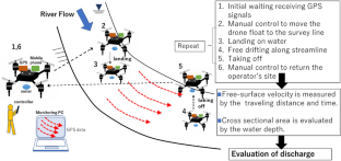
The present study develops a safety survey system for measuring natural river discharge. Monitoring of rivers is very important for river environment conservation and flood prevention. The new system is a drone-type float with a Global Positioning System (GPS) receiver, which can safely and quickly monitor a river. This float flies to the target point on a free surface according to the operator’s control. After which, it runs freely downstream, detecting the time-series of self-position with a centimeter-order accuracy using the real-time kinetic GPS method. It also measures the local water depth using an ultrasonic sensor during the drifting downstream. The same works are repeatedly conducted on all survey lines to evaluate the discharge through a target cross-section. The data correction formula considering the wind effects is introduced to improve the measurement accuracy. We performed field tests in natural rivers and obtained reliable results for practical application. The present system can evaluate the discharge in a 250 m width large-scale river without using an observation bridge or a rubber boat.
中文翻译:
用于河流表面流速测量的无人机式浮标的研制
本研究开发了一种用于测量自然河流流量的安全调查系统。河流监测对于河流环境保护和防汛十分重要。新系统是一种带有全球定位系统(GPS)接收器的无人机式浮标,可以安全快速地监测河流。该浮子根据操作员的控制飞到自由表面上的目标点。之后,它在下游自由运行,使用实时动态GPS方法以厘米级精度检测自身位置的时间序列。它还在下游漂流期间使用超声波传感器测量当地水深。在所有测量线上重复进行相同的工作,以评估通过目标横截面的排放。引入考虑风效应的数据修正公式,提高测量精度。我们在天然河流中进行了现场测试,并获得了可用于实际应用的可靠结果。本系统可以在不使用观景桥或橡皮艇的情况下评估250 m宽的大型河流的流量。


 京公网安备 11010802027423号