当前位置:
X-MOL 学术
›
Gondwana Res.
›
论文详情
Our official English website, www.x-mol.net, welcomes your
feedback! (Note: you will need to create a separate account there.)
Lithospheric thinning under the Araripe Basin (NE Brazil) from a long-period magnetotelluric survey: Constraints for tectonic inversion
Gondwana Research ( IF 7.2 ) Pub Date : 2019-04-01 , DOI: 10.1016/j.gr.2018.11.013 Xavier Garcia , Jordi Julià , Ana M. Nemocón , Maik Neukirch
Gondwana Research ( IF 7.2 ) Pub Date : 2019-04-01 , DOI: 10.1016/j.gr.2018.11.013 Xavier Garcia , Jordi Julià , Ana M. Nemocón , Maik Neukirch

|
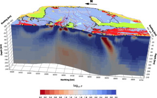
Abstract The lithospheric architecture of the western Borborema Province and northern Sao Francisco craton of NE Brazil has been investigated through analysis of long-period magnetotelluric data acquired along a 700 km long survey, using 12 instruments. The survey samples several tectonic terrains in the Province and penetrates into the adjacent Sao Francisco craton after crossing the Araripe Basin, an aborted rift basin filled with Mesozoic sediments that peak at ∼1000 m above mean sea level. High conductivities are observed at shallow depths under the main Precambrian shear zones that pervade the Province – consistent with tectonic reactivation – and as a small patch embedded within the high resistivities that characterize the Sao Francisco craton. High conductivities (∼25 Ωm) are also observed below 120 km depth between the Patos and Pernambuco lineaments – right under the Araripe Basin – flanked by resistive (>120 Ωm) material immediately to the north and south. This deep, highly conductive body is found consistent with the presence of melt and aqueous fluids, and is interpreted as shallow asthenospheric mantle bounded by thicker lithosphere. We propose that extensional stresses in the Mesozoic stretched and thinned the lithosphere under the Araripe Basin, causing passive upwelling of asthenospheric material and lateral flow of the overlying lithosphere, and resulting in thickening of the lithosphere under the flanks and uplift of the Araripe Basin. We also hypothesize that thermal weakening of the lithospheric mantle – perhaps sustained by channeling of asthenospheric flows under the basin – would have caused regional stresses to concentrate in the brittle upper crust and contribute to basin inversion. We thus propose that a combination of localized horizontal stresses and vertical buoyancy from underlying asthenospheric material are ultimately responsible for the actual topography of the Araripe Basin.
中文翻译:

来自长期大地电磁测量的阿拉里佩盆地(巴西东北部)下的岩石圈减薄:构造反转的约束
摘要 通过使用 12 台仪器对沿 700 公里长的调查所获得的长周期大地电磁数据进行分析,研究了博博雷马省西部和巴西东北部圣弗朗西斯科克拉通北部的岩石圈结构。该调查对该省的几个构造地形进行了采样,并在穿越阿拉里佩盆地后渗透到邻近的圣弗朗西斯科克拉通,这是一个充满中生代沉积物的流产裂谷盆地,其峰值位于平均海平面以上约 1000 米。在遍布该省的主要前寒武纪剪切带下的浅层观察到高电导率 - 与构造再激活一致 - 并且作为嵌入圣弗朗西斯科克拉通的高电阻率特征的小块。在 Patos 和 Pernambuco 沿线之间的 120 公里深度以下也观察到高电导率(~25 Ωm)——就在 Araripe 盆地下方——两侧是电阻(>120 Ωm)材料,紧邻北部和南部。这个深的、高导电性的物体被发现与熔体和含水流体的存在一致,并被解释为以较厚的岩石圈为界的浅软流圈地幔。我们认为,中生代的伸展应力使阿拉里佩盆地下方的岩石圈拉长变薄,导致软流圈物质被动上涌和上覆岩石圈侧向流动,导致阿拉里佩盆地侧翼下方岩石圈增厚和隆升。我们还假设岩石圈地幔的热弱化——可能是由盆地下软流圈流动的通道所维持的——会导致区域应力集中在脆性上地壳并导致盆地反转。因此,我们提出,局部水平应力和来自底层软流圈材料的垂直浮力的组合最终决定了阿拉里佩盆地的实际地形。
更新日期:2019-04-01
中文翻译:

来自长期大地电磁测量的阿拉里佩盆地(巴西东北部)下的岩石圈减薄:构造反转的约束
摘要 通过使用 12 台仪器对沿 700 公里长的调查所获得的长周期大地电磁数据进行分析,研究了博博雷马省西部和巴西东北部圣弗朗西斯科克拉通北部的岩石圈结构。该调查对该省的几个构造地形进行了采样,并在穿越阿拉里佩盆地后渗透到邻近的圣弗朗西斯科克拉通,这是一个充满中生代沉积物的流产裂谷盆地,其峰值位于平均海平面以上约 1000 米。在遍布该省的主要前寒武纪剪切带下的浅层观察到高电导率 - 与构造再激活一致 - 并且作为嵌入圣弗朗西斯科克拉通的高电阻率特征的小块。在 Patos 和 Pernambuco 沿线之间的 120 公里深度以下也观察到高电导率(~25 Ωm)——就在 Araripe 盆地下方——两侧是电阻(>120 Ωm)材料,紧邻北部和南部。这个深的、高导电性的物体被发现与熔体和含水流体的存在一致,并被解释为以较厚的岩石圈为界的浅软流圈地幔。我们认为,中生代的伸展应力使阿拉里佩盆地下方的岩石圈拉长变薄,导致软流圈物质被动上涌和上覆岩石圈侧向流动,导致阿拉里佩盆地侧翼下方岩石圈增厚和隆升。我们还假设岩石圈地幔的热弱化——可能是由盆地下软流圈流动的通道所维持的——会导致区域应力集中在脆性上地壳并导致盆地反转。因此,我们提出,局部水平应力和来自底层软流圈材料的垂直浮力的组合最终决定了阿拉里佩盆地的实际地形。


 京公网安备 11010802027423号