当前位置:
X-MOL 学术
›
Int. J. Parasitol.
›
论文详情
Our official English website, www.x-mol.net, welcomes your
feedback! (Note: you will need to create a separate account there.)
Prediction of hookworm prevalence in southern India using environmental parameters derived from Landsat 8 remotely sensed data.
International Journal for Parasitology ( IF 3.7 ) Pub Date : 2019-11-20 , DOI: 10.1016/j.ijpara.2019.10.001 Alexandra V Kulinkina 1 , Rajiv Sarkar 2 , Venkata R Mohan 3 , Yvonne Walz 4 , Saravanakumar P Kaliappan 2 , Sitara S R Ajjampur 2 , Honorine Ward 5 , Elena N Naumova 6 , Gagandeep Kang 2
International Journal for Parasitology ( IF 3.7 ) Pub Date : 2019-11-20 , DOI: 10.1016/j.ijpara.2019.10.001 Alexandra V Kulinkina 1 , Rajiv Sarkar 2 , Venkata R Mohan 3 , Yvonne Walz 4 , Saravanakumar P Kaliappan 2 , Sitara S R Ajjampur 2 , Honorine Ward 5 , Elena N Naumova 6 , Gagandeep Kang 2
Affiliation
|
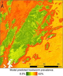
Soil-transmitted helminth infections propagate poverty and slow economic growth in low-income countries. As with many other neglected tropical diseases, environmental conditions are important determinants of soil-transmitted helminth transmission. Hence, remotely sensed data are commonly utilised in spatial risk models intended to inform control strategies. In the present study, we build upon the existing modelling approaches by utilising fine spatial resolution Landsat 8 remotely sensed data in combination with topographic variables to predict hookworm prevalence in a hilly tribal area in southern India. Hookworm prevalence data collected from two field surveys were used in a random forest model to investigate the predictive capacity of 15 environmental variables derived from two remotely sensed images acquired during dry and rainy seasons. A variable buffer radius (100-1000 m) was applied to the point-prevalence locations in order to integrate environmental conditions around the village centroids into the modelling approach and understand where transmission is more likely. Elevation and slope were the most important variables in the models, with lower elevation and higher slope correlating with higher transmission risk. A modified normalised difference water index was among other recurring important variables, likely responsible for some seasonal differences in model performance. The 300 m buffer distance produced the best model performance in this setting, with another spike at 700 m, and a marked drop-off in R2 values at 1000 m. In addition to assessing a large number of environmental correlates with hookworm transmission, the study contributes to the development of standardised methods of spatial linkage of continuous environmental data with point-based disease prevalence measures for the purpose of spatially explicit risk profiling.
中文翻译:

使用来自 Landsat 8 遥感数据的环境参数预测印度南部的钩虫流行率。
土壤传播的蠕虫感染会在低收入国家传播贫困并减缓经济增长。与许多其他被忽视的热带病一样,环境条件是土壤传播的蠕虫传播的重要决定因素。因此,遥感数据通常用于空间风险模型,旨在为控制策略提供信息。在本研究中,我们在现有建模方法的基础上,利用精细的空间分辨率 Landsat 8 遥感数据结合地形变量来预测印度南部丘陵部落地区的钩虫流行率。从两次实地调查中收集的钩虫流行数据用于随机森林模型,以研究从旱季和雨季获取的两幅遥感图像中得出的 15 个环境变量的预测能力。将可变缓冲区半径(100-1000 m)应用于点流行位置,以便将村庄质心周围的环境条件整合到建模方法中,并了解哪里更有可能传播。海拔和坡度是模型中最重要的变量,较低的海拔和较高的坡度与较高的传播风险相关。修改后的归一化差异水指数是其他反复出现的重要变量之一,可能导致模型性能出现一些季节性差异。300 m 缓冲距离在此设置中产生了最佳模型性能,在 700 m 处有另一个峰值,在 1000 m 处 R2 值明显下降。除了评估大量与钩虫传播相关的环境因素外,
更新日期:2019-11-20
中文翻译:
使用来自 Landsat 8 遥感数据的环境参数预测印度南部的钩虫流行率。
土壤传播的蠕虫感染会在低收入国家传播贫困并减缓经济增长。与许多其他被忽视的热带病一样,环境条件是土壤传播的蠕虫传播的重要决定因素。因此,遥感数据通常用于空间风险模型,旨在为控制策略提供信息。在本研究中,我们在现有建模方法的基础上,利用精细的空间分辨率 Landsat 8 遥感数据结合地形变量来预测印度南部丘陵部落地区的钩虫流行率。从两次实地调查中收集的钩虫流行数据用于随机森林模型,以研究从旱季和雨季获取的两幅遥感图像中得出的 15 个环境变量的预测能力。将可变缓冲区半径(100-1000 m)应用于点流行位置,以便将村庄质心周围的环境条件整合到建模方法中,并了解哪里更有可能传播。海拔和坡度是模型中最重要的变量,较低的海拔和较高的坡度与较高的传播风险相关。修改后的归一化差异水指数是其他反复出现的重要变量之一,可能导致模型性能出现一些季节性差异。300 m 缓冲距离在此设置中产生了最佳模型性能,在 700 m 处有另一个峰值,在 1000 m 处 R2 值明显下降。除了评估大量与钩虫传播相关的环境因素外,


 京公网安备 11010802027423号