Nature Astronomy ( IF 12.9 ) Pub Date : 2019-11-18 , DOI: 10.1038/s41550-019-0917-6 R M C Lopes 1 , M J Malaska 1 , A M Schoenfeld 2 , A Solomonidou 3 , S P D Birch 4 , M Florence 1 , A G Hayes 4 , D A Williams 5 , J Radebaugh 6 , T Verlander 7 , E P Turtle 8 , A Le Gall 9 , S Wall 1
|
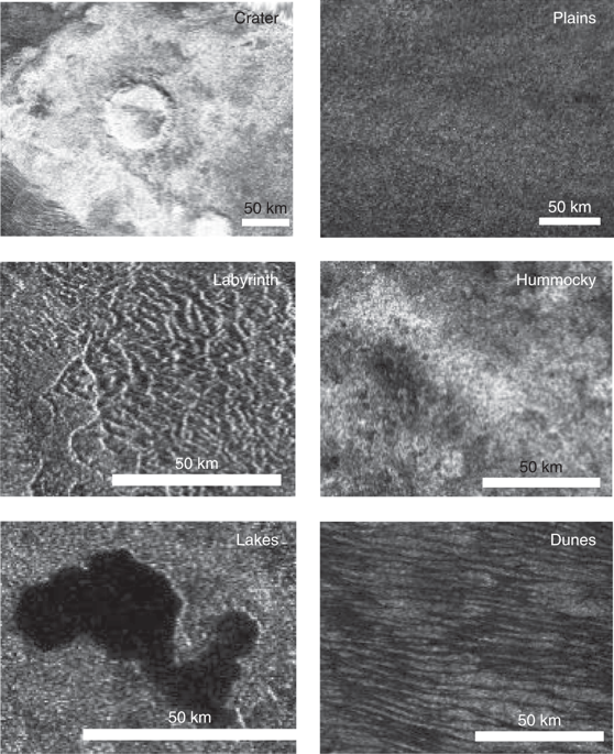
Titan has an active methane-based hydrologic cycle1 that has shaped a complex geologic landscape2, making its surface one of most geologically diverse in the Solar System. Despite the differences in materials, temperatures and gravity fields between Earth and Titan, many of their surface features are similar and can be interpreted as products of the same geologic processes3. However, Titan’s thick and hazy atmosphere has hindered the identification of its geologic features at visible wavelengths and the study of its surface composition4. Here we identify and map the major geological units on Titan’s surface using radar and infrared data from the Cassini orbiter spacecraft. Correlations between datasets enabled us to produce a global map even where datasets were incomplete. The spatial and superposition relations between major geological units reveals the likely temporal evolution of the landscape and providesinsight into the interacting processes driving its evolution. We extract the relative dating of the various geological units by observing their spatial superposition in order to get information on the temporal evolution of the landscape. The dunes and lakes are relatively young, whereas the hummocky or mountainous terrains are the oldest on Titan. Our results also show that Titan’s surface is dominated by sedimentary or depositional processes with a clear latitudinal variation, with dunes at the equator, plains at mid-latitudes and labyrinth terrains and lakes at the poles.
中文翻译:
土星“月亮巨人”的全球地貌图。
泰坦有一个活跃的基于甲烷的水文循环1,它形成了一个复杂的地质景观2,使其表面是太阳系中地质上变化最多的表面之一。尽管地球与土卫六之间在材料,温度和重力场方面存在差异,但它们的许多表面特征是相似的,可以解释为同一地质过程的产物3。但是,土卫六浓厚而朦胧的大气层阻碍了在可见光波长下对其地质特征的识别以及对它的表面成分的研究4。。在这里,我们使用来自卡西尼号轨道飞船的雷达和红外数据,识别并绘制了土卫六表面的主要地质单位并绘制了地图。数据集之间的相关性使我们能够生成全局地图,即使数据集不完整也是如此。主要地质单元之间的空间和叠加关系揭示了景观的可能时间演变,并提供了驱动其演化的相互作用过程的见识。我们通过观察它们的空间叠加来提取各个地质单位的相对年代,以便获得有关景观时间演变的信息。沙丘和湖泊相对较年轻,而山丘或丘陵地形是土卫六上最古老的地形。


 京公网安备 11010802027423号