当前位置:
X-MOL 学术
›
Remote Sens. Ecol. Conserv.
›
论文详情
Our official English website, www.x-mol.net, welcomes your feedback! (Note: you will need to create a separate account there.)
Tracking landscape scale vegetation change in the arid zone by integrating ground, drone and satellite data
Remote Sensing in Ecology and Conservation ( IF 5.5 ) Pub Date : 2023-12-07 , DOI: 10.1002/rse2.375 Roxane J. Francis 1 , Richard T. Kingsford 1 , Katherine Moseby 1, 2 , John Read 2 , Reece Pedler 1 , Adrian Fisher 1 , Justin McCann 3 , Rebecca West 1
Remote Sensing in Ecology and Conservation ( IF 5.5 ) Pub Date : 2023-12-07 , DOI: 10.1002/rse2.375 Roxane J. Francis 1 , Richard T. Kingsford 1 , Katherine Moseby 1, 2 , John Read 2 , Reece Pedler 1 , Adrian Fisher 1 , Justin McCann 3 , Rebecca West 1
Affiliation
|
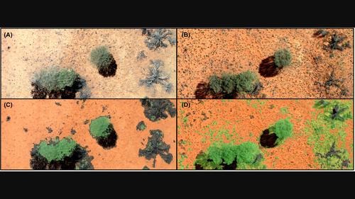
A combined multiscale approach using ground, drone and satellite surveys can provide accurate landscape scale spatial mapping and monitoring. We used field observations with drone collected imagery covering 70 ha annually for a 5-year period to estimate changes in living and dead vegetation of four widespread and abundant arid zone woody shrub species. Random forest classifiers delivered high accuracy (> 95%) using object-based detection methods, with fast repeatable and transferrable processing using Google Earth Engine. Our classifiers performed well in both dominant arid zone landscape types: dune and swale, and at extremes of dry and wet years with minimal alterations. This highlighted the flexibility of the approach, potentially delivering insights into changes in highly variable environments. We also linked this classified drone vegetation to available temporally and spatially explicit Landsat satellite imagery, training a new, more accurate fractional vegetation cover model, allowing for accurate tracking of vegetation responses at large scales in the arid zone. Our method promises considerable opportunity to track vegetation dynamics including responses to management interventions, at large geographic scales, extending inference well beyond ground surveys.
中文翻译:

通过整合地面、无人机和卫星数据跟踪干旱区景观尺度植被变化
使用地面、无人机和卫星调查的组合多尺度方法可以提供准确的景观尺度空间测绘和监测。我们利用无人机在 5 年内每年收集的 70 公顷图像进行实地观测,估计四种分布广泛且丰富的干旱区木本灌木物种的活植被和死植被的变化。随机森林分类器使用基于对象的检测方法提供高精度 (> 95%),并使用 Google Earth Engine 进行快速可重复和可传输处理。我们的分类器在两种主要干旱地区景观类型:沙丘和洼地,以及在极端干燥和潮湿年份中表现良好,变化最小。这凸显了该方法的灵活性,有可能提供对高度可变环境中变化的洞察。我们还将这种分类的无人机植被与可用的时间和空间明确的 Landsat 卫星图像联系起来,训练一个新的、更准确的植被覆盖率模型,从而能够准确跟踪干旱地区大范围的植被响应。我们的方法提供了相当多的机会来跟踪植被动态,包括在大地理范围内对管理干预措施的反应,将推断扩展到地面调查之外。
更新日期:2023-12-10
中文翻译:
通过整合地面、无人机和卫星数据跟踪干旱区景观尺度植被变化
使用地面、无人机和卫星调查的组合多尺度方法可以提供准确的景观尺度空间测绘和监测。我们利用无人机在 5 年内每年收集的 70 公顷图像进行实地观测,估计四种分布广泛且丰富的干旱区木本灌木物种的活植被和死植被的变化。随机森林分类器使用基于对象的检测方法提供高精度 (> 95%),并使用 Google Earth Engine 进行快速可重复和可传输处理。我们的分类器在两种主要干旱地区景观类型:沙丘和洼地,以及在极端干燥和潮湿年份中表现良好,变化最小。这凸显了该方法的灵活性,有可能提供对高度可变环境中变化的洞察。我们还将这种分类的无人机植被与可用的时间和空间明确的 Landsat 卫星图像联系起来,训练一个新的、更准确的植被覆盖率模型,从而能够准确跟踪干旱地区大范围的植被响应。我们的方法提供了相当多的机会来跟踪植被动态,包括在大地理范围内对管理干预措施的反应,将推断扩展到地面调查之外。


 京公网安备 11010802027423号