当前位置:
X-MOL 学术
›
Remote Sens. Ecol. Conserv.
›
论文详情
Our official English website, www.x-mol.net, welcomes your feedback! (Note: you will need to create a separate account there.)
Grassland-use intensity maps for Switzerland based on satellite time series: Challenges and opportunities for ecological applications
Remote Sensing in Ecology and Conservation ( IF 5.5 ) Pub Date : 2023-10-27 , DOI: 10.1002/rse2.372 Dominique Weber 1 , Marcel Schwieder 2, 3 , Lukas Ritter 1 , Tiziana Koch 1, 4 , Achilleas Psomas 1 , Nica Huber 1 , Christian Ginzler 1 , Steffen Boch 1
Remote Sensing in Ecology and Conservation ( IF 5.5 ) Pub Date : 2023-10-27 , DOI: 10.1002/rse2.372 Dominique Weber 1 , Marcel Schwieder 2, 3 , Lukas Ritter 1 , Tiziana Koch 1, 4 , Achilleas Psomas 1 , Nica Huber 1 , Christian Ginzler 1 , Steffen Boch 1
Affiliation
|
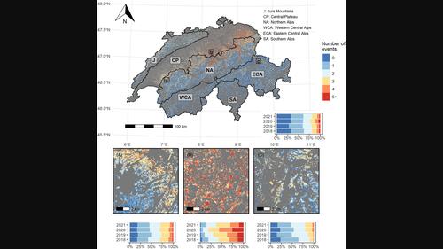
Land-use intensification in grassland ecosystems (i.e. increased mowing frequency, intensified grazing) has a strong negative effect on biodiversity and ecosystem services. However, accurate information on grassland-use intensity is difficult to acquire and restricted to the local or regional level. Recent studies have shown that mowing events can be mapped for large areas using satellite image time series. The transferability of such approaches, especially to mountain areas, has been little explored, however, and the relevance for ecological applications in biodiversity and conservation has hardly been investigated. Here, we used a rule-based algorithm to produce annual maps for 2018–2021 of grassland-management events, that is, mowing and/or grazing, for Switzerland using Sentinel-2 and Landsat 8 satellite data. We assessed the detection of management events based on independent reference data, which we acquired from daily time series of publicly available webcams that are widely distributed across Switzerland. We further examined the relationships between the generated grassland-use intensity measures and plant species richness and ecological indicator values derived from a nationwide field survey. The webcam-based verification for 2020 and 2021 revealed that most detected management events were actual mowing/grazing events (≥78%), but that a substantial number of events were not detected (up to 57%), particularly grazing events at higher elevations. We found lower plant species richness and higher mean ecological indicator values for nutrients and mowing tolerance with more frequent management events and those starting earlier in the year. A large proportion of the variance was explained by our use-intensity measures. Our findings therefore highlight that remotely assessed management events can characterise land-use intensity at fine spatial and temporal resolutions across broad scales and can explain plant biodiversity patterns in grasslands.
中文翻译:

基于卫星时间序列的瑞士草原利用强度图:生态应用的挑战和机遇
草原生态系统的土地利用集约化(即增加割草频率、强化放牧)对生物多样性和生态系统服务产生强烈的负面影响。然而,关于草地利用强度的准确信息很难获得,并且仅限于地方或区域层面。最近的研究表明,可以使用卫星图像时间序列来绘制大面积的割草事件图。然而,这些方法的可转移性,特别是在山区的可转移性,却很少被探索,而且在生物多样性和保护方面的生态应用的相关性也几乎没有被研究。在这里,我们使用基于规则的算法,利用 Sentinel-2 和 Landsat 8 卫星数据,制作了瑞士 2018 年至 2021 年草地管理事件(即割草和/或放牧)的年度地图。我们根据独立参考数据评估了管理事件的检测,这些数据是从广泛分布在瑞士各地的公开网络摄像头的每日时间序列中获取的。我们进一步研究了全国实地调查所产生的草地利用强度指标与植物物种丰富度和生态指标值之间的关系。2020 年和 2021 年基于网络摄像头的验证显示,大多数检测到的管理事件是实际割草/放牧事件(≥78%),但大量事件未检测到(高达 57%),特别是高海拔地区的放牧事件。我们发现,由于更频繁的管理活动以及今年早些时候开始的管理活动,植物物种丰富度较低,养分和割草耐受性的平均生态指标值较高。很大一部分方差是通过我们的使用强度测量来解释的。因此,我们的研究结果强调,远程评估的管理事件可以在广泛的尺度上以精细的空间和时间分辨率表征土地利用强度,并可以解释草原的植物生物多样性模式。
更新日期:2023-10-31
中文翻译:
基于卫星时间序列的瑞士草原利用强度图:生态应用的挑战和机遇
草原生态系统的土地利用集约化(即增加割草频率、强化放牧)对生物多样性和生态系统服务产生强烈的负面影响。然而,关于草地利用强度的准确信息很难获得,并且仅限于地方或区域层面。最近的研究表明,可以使用卫星图像时间序列来绘制大面积的割草事件图。然而,这些方法的可转移性,特别是在山区的可转移性,却很少被探索,而且在生物多样性和保护方面的生态应用的相关性也几乎没有被研究。在这里,我们使用基于规则的算法,利用 Sentinel-2 和 Landsat 8 卫星数据,制作了瑞士 2018 年至 2021 年草地管理事件(即割草和/或放牧)的年度地图。我们根据独立参考数据评估了管理事件的检测,这些数据是从广泛分布在瑞士各地的公开网络摄像头的每日时间序列中获取的。我们进一步研究了全国实地调查所产生的草地利用强度指标与植物物种丰富度和生态指标值之间的关系。2020 年和 2021 年基于网络摄像头的验证显示,大多数检测到的管理事件是实际割草/放牧事件(≥78%),但大量事件未检测到(高达 57%),特别是高海拔地区的放牧事件。我们发现,由于更频繁的管理活动以及今年早些时候开始的管理活动,植物物种丰富度较低,养分和割草耐受性的平均生态指标值较高。很大一部分方差是通过我们的使用强度测量来解释的。因此,我们的研究结果强调,远程评估的管理事件可以在广泛的尺度上以精细的空间和时间分辨率表征土地利用强度,并可以解释草原的植物生物多样性模式。


 京公网安备 11010802027423号