当前位置:
X-MOL 学术
›
Remote Sens. Ecol. Conserv.
›
论文详情
Our official English website, www.x-mol.net, welcomes your feedback! (Note: you will need to create a separate account there.)
Gray whale detection in satellite imagery using deep learning
Remote Sensing in Ecology and Conservation ( IF 5.5 ) Pub Date : 2023-06-22 , DOI: 10.1002/rse2.352 Katherine M. Green 1, 2 , Mala K. Virdee 2 , Hannah C. Cubaynes 1 , Angelica I. Aviles‐Rivero 3 , Peter T. Fretwell 1 , Patrick C. Gray 4 , David W. Johnston 4 , Carola‐Bibiane Schönlieb 3 , Leigh G. Torres 5 , Jennifer A. Jackson 1
Remote Sensing in Ecology and Conservation ( IF 5.5 ) Pub Date : 2023-06-22 , DOI: 10.1002/rse2.352 Katherine M. Green 1, 2 , Mala K. Virdee 2 , Hannah C. Cubaynes 1 , Angelica I. Aviles‐Rivero 3 , Peter T. Fretwell 1 , Patrick C. Gray 4 , David W. Johnston 4 , Carola‐Bibiane Schönlieb 3 , Leigh G. Torres 5 , Jennifer A. Jackson 1
Affiliation
|
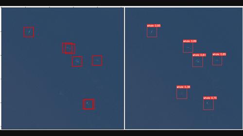
The combination of very high resolution (VHR) satellite remote sensing imagery and deep learning via convolutional neural networks provides opportunities to improve global whale population surveys through increasing efficiency and spatial coverage. Many whale species are recovering from commercial whaling and face multiple anthropogenic threats. Regular, accurate population surveys are therefore of high importance for conservation efforts. In this study, a state-of-the-art object detection model (YOLOv5) was trained to detect gray whales (Eschrichtius robustus) in VHR satellite images, using training data derived from satellite images spanning different sea states in a key breeding habitat, as well as aerial imagery collected by unoccupied aircraft systems. Varying combinations of aerial and satellite imagery were incorporated into the training set. Mean average precision, whale precision, and recall ranged from 0.823 to 0.922, 0.800 to 0.939, and 0.843 to 0.889, respectively, across eight experiments. The results imply that including aerial imagery in the training data did not substantially impact model performance, and therefore, expansion of representative satellite datasets should be prioritized. The accuracy of the results on real-world data, along with short training times, indicates the potential of using this method to automate whale detection for population surveys.
中文翻译:

使用深度学习在卫星图像中检测灰鲸
极高分辨率 (VHR) 卫星遥感图像与卷积神经网络深度学习相结合,为通过提高效率和空间覆盖范围来改进全球鲸鱼种群调查提供了机会。许多鲸鱼物种正在从商业捕鲸中恢复,并面临多种人为威胁。因此,定期、准确的人口调查对于保护工作非常重要。在这项研究中,使用从关键繁殖栖息地跨越不同海况的卫星图像获得的训练数据,训练了最先进的目标检测模型(YOLOv5)来检测VHR 卫星图像中的灰鲸(EschrichtiusRobustus) ,以及由无人居住的飞机系统收集的航空图像。航空和卫星图像的不同组合被纳入训练集中。在八项实验中,平均精确度、鲸鱼精确度和召回率分别为 0.823 至 0.922、0.800 至 0.939 和 0.843 至 0.889。结果表明,在训练数据中包含航空图像不会对模型性能产生重大影响,因此,应优先考虑扩展代表性卫星数据集。现实世界数据结果的准确性以及较短的训练时间表明使用这种方法自动检测鲸鱼以进行种群调查的潜力。
更新日期:2023-06-22
中文翻译:
使用深度学习在卫星图像中检测灰鲸
极高分辨率 (VHR) 卫星遥感图像与卷积神经网络深度学习相结合,为通过提高效率和空间覆盖范围来改进全球鲸鱼种群调查提供了机会。许多鲸鱼物种正在从商业捕鲸中恢复,并面临多种人为威胁。因此,定期、准确的人口调查对于保护工作非常重要。在这项研究中,使用从关键繁殖栖息地跨越不同海况的卫星图像获得的训练数据,训练了最先进的目标检测模型(YOLOv5)来检测VHR 卫星图像中的灰鲸(EschrichtiusRobustus) ,以及由无人居住的飞机系统收集的航空图像。航空和卫星图像的不同组合被纳入训练集中。在八项实验中,平均精确度、鲸鱼精确度和召回率分别为 0.823 至 0.922、0.800 至 0.939 和 0.843 至 0.889。结果表明,在训练数据中包含航空图像不会对模型性能产生重大影响,因此,应优先考虑扩展代表性卫星数据集。现实世界数据结果的准确性以及较短的训练时间表明使用这种方法自动检测鲸鱼以进行种群调查的潜力。


 京公网安备 11010802027423号