当前位置:
X-MOL 学术
›
Remote Sens. Ecol. Conserv.
›
论文详情
Our official English website, www.x-mol.net, welcomes your feedback! (Note: you will need to create a separate account there.)
Accurate delineation of individual tree crowns in tropical forests from aerial RGB imagery using Mask R-CNN
Remote Sensing in Ecology and Conservation ( IF 5.5 ) Pub Date : 2023-05-13 , DOI: 10.1002/rse2.332 James G. C. Ball 1, 2, 3 , Sebastian H. M. Hickman 4, 5 , Tobias D. Jackson 1, 2 , Xian Jing Koay 2 , James Hirst 6 , William Jay 7 , Matthew Archer 8 , Mélaine Aubry‐Kientz 9 , Grégoire Vincent 3 , David A. Coomes 1, 2
Remote Sensing in Ecology and Conservation ( IF 5.5 ) Pub Date : 2023-05-13 , DOI: 10.1002/rse2.332 James G. C. Ball 1, 2, 3 , Sebastian H. M. Hickman 4, 5 , Tobias D. Jackson 1, 2 , Xian Jing Koay 2 , James Hirst 6 , William Jay 7 , Matthew Archer 8 , Mélaine Aubry‐Kientz 9 , Grégoire Vincent 3 , David A. Coomes 1, 2
Affiliation
|
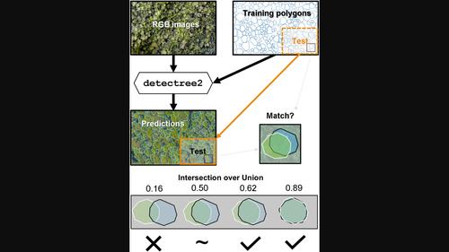
Tropical forests are a major component of the global carbon cycle and home to two-thirds of terrestrial species. Upper-canopy trees store the majority of forest carbon and can be vulnerable to drought events and storms. Monitoring their growth and mortality is essential to understanding forest resilience to climate change, but in the context of forest carbon storage, large trees are underrepresented in traditional field surveys, so estimates are poorly constrained. Aerial photographs provide spectral and textural information to discriminate between tree crowns in diverse, complex tropical canopies, potentially opening the door to landscape monitoring of large trees. Here we describe a new deep convolutional neural network method, Detectree2, which builds on the Mask R-CNN computer vision framework to recognize the irregular edges of individual tree crowns from airborne RGB imagery. We trained and evaluated this model with 3797 manually delineated tree crowns at three sites in Malaysian Borneo and one site in French Guiana. As an example application, we combined the delineations with repeat lidar surveys (taken between 3 and 6 years apart) of the four sites to estimate the growth and mortality of upper-canopy trees. Detectree2 delineated 65 000 upper-canopy trees across 14 km2 of aerial images. The skill of the automatic method in delineating unseen test trees was good (F1 score = 0.64) and for the tallest category of trees was excellent (F1 score = 0.74). As predicted from previous field studies, we found that growth rate declined with tree height and tall trees had higher mortality rates than intermediate-size trees. Our approach demonstrates that deep learning methods can automatically segment trees in widely accessible RGB imagery. This tool (provided as an open-source Python package) has many potential applications in forest ecology and conservation, from estimating carbon stocks to monitoring forest phenology and restoration.
中文翻译:

使用 Mask R-CNN 从航空 RGB 图像准确描绘热带森林中的单个树冠
热带森林是全球碳循环的主要组成部分,也是三分之二陆地物种的家园。树冠上部的树木储存了大部分森林碳,很容易受到干旱和风暴的影响。监测它们的生长和死亡率对于了解森林对气候变化的适应能力至关重要,但在森林碳储存的背景下,大型树木在传统的实地调查中代表性不足,因此估计值受到很大限制。航空照片提供光谱和纹理信息,以区分不同、复杂的热带树冠中的树冠,这可能为大型树木的景观监测打开大门。在这里,我们描述了一种新的深度卷积神经网络方法Detectree2,它建立在 Mask R-CNN 计算机视觉框架的基础上,可以从机载 RGB 图像中识别单个树冠的不规则边缘。我们使用马来西亚婆罗洲三个地点和法属圭亚那一个地点的 3797 个手动描绘的树冠来训练和评估该模型。作为示例应用,我们将四个地点的轮廓与重复激光雷达调查(相隔 3 到 6 年)结合起来,以估计树冠上部树木的生长和死亡率。Detectree2在 14 km 2的航拍图像中描绘了 65 000 棵上层树冠树木。自动方法在描绘未见过的测试树木方面的技能很好(F 1得分 = 0.64),并且对于最高类别的树木也非常出色(F 1得分 = 0.74)。正如之前的实地研究预测的那样,我们发现生长率随着树高的增加而下降,高大的树木比中等大小的树木死亡率更高。我们的方法表明深度学习方法可以在广泛访问的 RGB 图像中自动分割树木。该工具(作为开源 Python 包提供)在森林生态和保护方面具有许多潜在应用,从估计碳储量到监测森林物候和恢复。
更新日期:2023-05-13
中文翻译:
使用 Mask R-CNN 从航空 RGB 图像准确描绘热带森林中的单个树冠
热带森林是全球碳循环的主要组成部分,也是三分之二陆地物种的家园。树冠上部的树木储存了大部分森林碳,很容易受到干旱和风暴的影响。监测它们的生长和死亡率对于了解森林对气候变化的适应能力至关重要,但在森林碳储存的背景下,大型树木在传统的实地调查中代表性不足,因此估计值受到很大限制。航空照片提供光谱和纹理信息,以区分不同、复杂的热带树冠中的树冠,这可能为大型树木的景观监测打开大门。在这里,我们描述了一种新的深度卷积神经网络方法Detectree2,它建立在 Mask R-CNN 计算机视觉框架的基础上,可以从机载 RGB 图像中识别单个树冠的不规则边缘。我们使用马来西亚婆罗洲三个地点和法属圭亚那一个地点的 3797 个手动描绘的树冠来训练和评估该模型。作为示例应用,我们将四个地点的轮廓与重复激光雷达调查(相隔 3 到 6 年)结合起来,以估计树冠上部树木的生长和死亡率。Detectree2在 14 km 2的航拍图像中描绘了 65 000 棵上层树冠树木。自动方法在描绘未见过的测试树木方面的技能很好(F 1得分 = 0.64),并且对于最高类别的树木也非常出色(F 1得分 = 0.74)。正如之前的实地研究预测的那样,我们发现生长率随着树高的增加而下降,高大的树木比中等大小的树木死亡率更高。我们的方法表明深度学习方法可以在广泛访问的 RGB 图像中自动分割树木。该工具(作为开源 Python 包提供)在森林生态和保护方面具有许多潜在应用,从估计碳储量到监测森林物候和恢复。


 京公网安备 11010802027423号