当前位置:
X-MOL 学术
›
Remote Sens. Ecol. Conserv.
›
论文详情
Our official English website, www.x-mol.net, welcomes your feedback! (Note: you will need to create a separate account there.)
Characterizing aboveground biomass and tree cover of regrowing forests in Brazil using multi-source remote sensing data
Remote Sensing in Ecology and Conservation ( IF 5.5 ) Pub Date : 2023-04-27 , DOI: 10.1002/rse2.328 Na Chen 1 , Nandin‐Erdene Tsendbazar 1 , Daniela Requena Suarez 1 , Jan Verbesselt 1 , Martin Herold 1, 2
Remote Sensing in Ecology and Conservation ( IF 5.5 ) Pub Date : 2023-04-27 , DOI: 10.1002/rse2.328 Na Chen 1 , Nandin‐Erdene Tsendbazar 1 , Daniela Requena Suarez 1 , Jan Verbesselt 1 , Martin Herold 1, 2
Affiliation
|
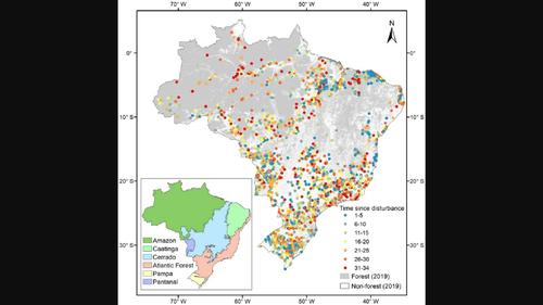
Characterization of regrowing forests is vital for understanding forest dynamics to assess the impacts on carbon stocks and to support sustainable forest management. Although remote sensing is a key tool for understanding and monitoring forest dynamics, the use of exclusively remotely sensed data to explore the effects of different variables on regrowing forests across all biomes in Brazil has rarely been investigated. Here, we analyzed how environmental and human factors affect regrowing forests. Based on Brazil's secondary forest age map, 3060 locations disturbed between 1984 and 2018 were sampled, interpreted and analyzed in different biomes. We interpreted the time since disturbance for the sampled pixels in Google Earth Engine. Elevation, slope, climatic water deficit (CWD), the total Nitrogen of soil, cation exchange capacity (CEC) of soil, surrounding tree cover, distance to roads, distance to settlements and fire frequency were analyzed in their importance for predicting aboveground biomass (AGB) and tree cover derived from global forest aboveground biomass map and tree cover map, respectively. Results show that time since disturbance interpreted from satellite time series is the most important predictor for characterizing AGB and tree cover of regrowing forests. AGB increased with increasing time since disturbance, surrounding tree cover, soil total N, slope, distance to roads, distance to settlements and decreased with larger fire frequency, CWD and CEC of soil. Tree cover increased with larger time since disturbance, soil total N, surrounding tree cover, distance to roads, distance to settlements, slope and decreased with increasing elevation and CWD. These results emphasize the importance of remotely sensing products as key opportunities to improve the characterization of forest regrowth and to reduce data gaps and uncertainties related to forest carbon sink estimation. Our results provide a better understanding of regional forest dynamics, toward developing and assessing effective forest-related restoration and climatic mitigation strategies.
中文翻译:

使用多源遥感数据表征巴西再生森林的地上生物量和树木覆盖率
再生森林的特征对于了解森林动态、评估对碳储量的影响和支持可持续森林管理至关重要。尽管遥感是了解和监测森林动态的关键工具,但很少研究使用专门的遥感数据来探索不同变量对巴西所有生物群落森林再生的影响。在这里,我们分析了环境和人为因素如何影响森林再生。根据巴西的次生林年龄图,对 1984 年至 2018 年间不同生物群落的 3060 个受到干扰的地点进行了采样、解释和分析。我们解释了 Google Earth Engine 中采样像素受到干扰后的时间。海拔、坡度、气候缺水量 (CWD)、土壤总氮、分析了土壤的阳离子交换能力(CEC)、周围的树木覆盖、到道路的距离、到定居点的距离和火灾频率对于根据全球森林地上生物量图和树木覆盖图预测地上生物量(AGB)和树木覆盖的重要性,分别。结果表明,从卫星时间序列解释的干扰以来的时间是表征再生森林的 AGB 和树木覆盖率的最重要的预测因子。AGB随着扰动后时间、周围树木覆盖度、土壤全氮、坡度、到道路的距离、到居民点的距离的增加而增加,随着火灾频率、土壤CWD和CEC的增加而减少。树木覆盖率随着扰动后时间的延长而增加,土壤总氮、周围树木覆盖率、到道路的距离、到定居点的距离、坡度并随着海拔和 CWD 的增加而减小。这些结果强调了遥感产品作为改善森林再生特征和减少与森林碳汇估算相关的数据差距和不确定性的关键机会的重要性。我们的研究结果使人们更好地了解区域森林动态,从而制定和评估有效的森林相关恢复和气候缓解战略。
更新日期:2023-04-27
中文翻译:
使用多源遥感数据表征巴西再生森林的地上生物量和树木覆盖率
再生森林的特征对于了解森林动态、评估对碳储量的影响和支持可持续森林管理至关重要。尽管遥感是了解和监测森林动态的关键工具,但很少研究使用专门的遥感数据来探索不同变量对巴西所有生物群落森林再生的影响。在这里,我们分析了环境和人为因素如何影响森林再生。根据巴西的次生林年龄图,对 1984 年至 2018 年间不同生物群落的 3060 个受到干扰的地点进行了采样、解释和分析。我们解释了 Google Earth Engine 中采样像素受到干扰后的时间。海拔、坡度、气候缺水量 (CWD)、土壤总氮、分析了土壤的阳离子交换能力(CEC)、周围的树木覆盖、到道路的距离、到定居点的距离和火灾频率对于根据全球森林地上生物量图和树木覆盖图预测地上生物量(AGB)和树木覆盖的重要性,分别。结果表明,从卫星时间序列解释的干扰以来的时间是表征再生森林的 AGB 和树木覆盖率的最重要的预测因子。AGB随着扰动后时间、周围树木覆盖度、土壤全氮、坡度、到道路的距离、到居民点的距离的增加而增加,随着火灾频率、土壤CWD和CEC的增加而减少。树木覆盖率随着扰动后时间的延长而增加,土壤总氮、周围树木覆盖率、到道路的距离、到定居点的距离、坡度并随着海拔和 CWD 的增加而减小。这些结果强调了遥感产品作为改善森林再生特征和减少与森林碳汇估算相关的数据差距和不确定性的关键机会的重要性。我们的研究结果使人们更好地了解区域森林动态,从而制定和评估有效的森林相关恢复和气候缓解战略。


 京公网安备 11010802027423号