当前位置:
X-MOL 学术
›
Remote Sens. Ecol. Conserv.
›
论文详情
Our official English website, www.x-mol.net, welcomes your feedback! (Note: you will need to create a separate account there.)
Combining unmanned aerial vehicles and satellite imagery to quantify areal extent of intertidal brown canopy-forming macroalgae
Remote Sensing in Ecology and Conservation ( IF 5.5 ) Pub Date : 2023-03-10 , DOI: 10.1002/rse2.327 Pippa H. Lewis 1, 2 , Benjamin P. Roberts 2 , Pippa J. Moore 2, 3 , Samuel Pike 4 , Anthony Scarth 4 , Katie Medcalf 4 , Iain Cameron 4
Remote Sensing in Ecology and Conservation ( IF 5.5 ) Pub Date : 2023-03-10 , DOI: 10.1002/rse2.327 Pippa H. Lewis 1, 2 , Benjamin P. Roberts 2 , Pippa J. Moore 2, 3 , Samuel Pike 4 , Anthony Scarth 4 , Katie Medcalf 4 , Iain Cameron 4
Affiliation
|
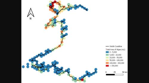
Brown macroalgae habitats provide a range of ecosystem services, offering coastal protection, supporting and increasing biodiversity, and more recently have been recognized for their potential role as blue carbon habitats. Consequently, accurate areal estimates of these habitats are vitally important. Satellite imagery is often utilized for areal estimates of vegetated habitats due to their ability to capture vast areas but are disadvantaged by their lower resolution. In contrast, imagery collected by unmanned aerial vehicles (UAV) provide high-resolution datasets but are unable to cover the necessary spatial scale required for calculating areal estimates at regional, national or international scales. This study successfully and accurately corrects the outputs from low-resolution Sentinel 2 imagery to the standard of high-resolution UAV imagery by using a novel brown algae index and a simple regression model to provide accurate spatial estimates. This model was applied to rocky shores across Wales, UK to predict a spatial extent of 6.2 km2 for three fucoid macroalgae species; Ascophyllum nodosum, Fucus vesiculosus and F. serratus. The regression model was validated in two ways. First, the data used to create the regression model was split to train and test (50:50) the model, with a root mean square error of ~8%–14%. Secondly, spatial estimates of fucoids in independent aerial imagery were assessed using aerial photography interpretation and compared to that of the regression model (7% difference). The carbon standing stock of fucoids calculated from the spatial estimate (6.2 km2) was found to be significantly lower than that of other marine carbon stores, indicating that fucoids do not significantly contribute as a blue carbon habitat based on biomass alone. This study produces a robust and accurate remote sensing technique to estimate spatial extent of macroalgae at large spatial scales, with possible worldwide applicability.
中文翻译:

结合无人机和卫星图像来量化潮间带棕色树冠形成大型藻类的面积范围
褐藻栖息地提供一系列生态系统服务,提供海岸保护,支持和增加生物多样性,最近还因其作为蓝碳栖息地的潜在作用而得到认可。因此,对这些栖息地的准确面积估计至关重要。卫星图像通常用于对植被栖息地进行面积估计,因为它们能够捕获大片区域,但因其分辨率较低而处于不利地位。相比之下,无人机(UAV)收集的图像提供高分辨率数据集,但无法覆盖计算区域、国家或国际尺度的面积估计所需的必要空间尺度。这项研究通过使用新型褐藻指数和简单的回归模型来提供准确的空间估计,成功准确地将低分辨率 Sentinel 2 图像的输出校正为高分辨率无人机图像的标准。该模型应用于英国威尔士的岩石海岸,预测空间范围为 6.2 公里2对于三种岩藻类大型藻类物种;泡叶藻、墨角藻和锯齿藻。回归模型通过两种方式进行验证。首先,将用于创建回归模型的数据进行分割以训练和测试 (50:50) 模型,均方根误差约为 8%–14%。其次,使用航空摄影解释评估独立航空图像中岩藻类的空间估计,并与回归模型的空间估计进行比较(7% 的差异)。根据空间估计计算出的岩藻类碳储量(6.2 km 2)被发现显着低于其他海洋碳储存,表明岩藻类物质作为仅基于生物量的蓝碳栖息地并没有显着贡献。这项研究产生了一种强大而准确的遥感技术,可以在大空间尺度上估计大型藻类的空间范围,并可能在全球范围内适用。
更新日期:2023-03-10
中文翻译:
结合无人机和卫星图像来量化潮间带棕色树冠形成大型藻类的面积范围
褐藻栖息地提供一系列生态系统服务,提供海岸保护,支持和增加生物多样性,最近还因其作为蓝碳栖息地的潜在作用而得到认可。因此,对这些栖息地的准确面积估计至关重要。卫星图像通常用于对植被栖息地进行面积估计,因为它们能够捕获大片区域,但因其分辨率较低而处于不利地位。相比之下,无人机(UAV)收集的图像提供高分辨率数据集,但无法覆盖计算区域、国家或国际尺度的面积估计所需的必要空间尺度。这项研究通过使用新型褐藻指数和简单的回归模型来提供准确的空间估计,成功准确地将低分辨率 Sentinel 2 图像的输出校正为高分辨率无人机图像的标准。该模型应用于英国威尔士的岩石海岸,预测空间范围为 6.2 公里2对于三种岩藻类大型藻类物种;泡叶藻、墨角藻和锯齿藻。回归模型通过两种方式进行验证。首先,将用于创建回归模型的数据进行分割以训练和测试 (50:50) 模型,均方根误差约为 8%–14%。其次,使用航空摄影解释评估独立航空图像中岩藻类的空间估计,并与回归模型的空间估计进行比较(7% 的差异)。根据空间估计计算出的岩藻类碳储量(6.2 km 2)被发现显着低于其他海洋碳储存,表明岩藻类物质作为仅基于生物量的蓝碳栖息地并没有显着贡献。这项研究产生了一种强大而准确的遥感技术,可以在大空间尺度上估计大型藻类的空间范围,并可能在全球范围内适用。


 京公网安备 11010802027423号