Precision Agriculture ( IF 5.4 ) Pub Date : 2023-02-27 , DOI: 10.1007/s11119-023-09993-9 Jacopo Furlanetto 1 , Nicola Dal Ferro 2 , Matteo Longo 2 , Luigi Sartori 1 , Riccardo Polese 2 , Daniele Caceffo 3 , Lorenzo Nicoli 3 , Francesco Morari 2
|
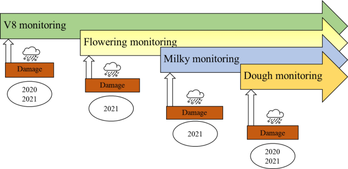
Extreme events such as hailstorms are a cause for concern in agriculture, leading to both economic and food supply losses. Traditional damage estimation techniques have recently been called into question since damages have rarely been quantified at the large-field scale. Damage-estimation methods used by field inspectors are complex and sometimes subjective and hardly account for damage spatial variability. In this work, a normalized difference vegetation index (NDVI)-based parametric method was applied using both unmanned aerial vehicles (UAV) and Sentinel-2 sensors to estimate the leaf area index (LAI) of maize (Zea mays L.) resulting from simulated hail damage. These methods were then compared to the LAI values generated from the Sentinel-2 Biophysical Processor. A two-year experiment (2020–2021) was conducted during the maize cropping season, with hail events simulated during a range of maize developmental stages (the 8th-leaf, flowering, milky and dough stages) using a 0–40% defoliation gradient of damage intensities performed with the aid of specifically designed prototype machines. The results showed that both sensors were able to accurately estimate LAI in a nonstandard damaged canopy while requiring only the calibration of the extinction coefficient \(k(\vartheta )\) in the case of parametric estimations. In this case, the calibration was performed using 2020 data, providing \(k(\vartheta )\) values of 0.59 for Sentinel-2 and 0.37 for the UAV sensor. The validation was performed on 2021 data, and showed that the UAV sensor had the best accuracy (R2 of 0.86, root-mean-square error (RMSE) of 0.71). The \(k(\vartheta )\) value proved to be sensor-specific, accounting for the NDVI retrieval differences likely caused by the different spatial operational scales of the two sensors. NDVI proved effective in parametrically estimating maize LAI under damaged canopy conditions at different defoliation degrees. The parametric method matched the Sentinel-2 biophysical process-generated LAI well, leading to less underestimations and more accurate LAI retrieval.
中文翻译:
使用 Sentinel-2 和无人机图像在玉米 (Zea mays L.) 冰雹落叶后通过遥感 NDVI 估算 LAI
冰雹等极端事件引起农业关注,导致经济和粮食供应损失。传统的损伤估计技术最近受到了质疑,因为损伤很少在大范围内进行量化。现场检查员使用的损坏估计方法很复杂,有时还很主观,并且很难考虑损坏的空间变化。在这项工作中,采用基于归一化植被指数 (NDVI) 的参数化方法,使用无人机 (UAV) 和 Sentinel-2 传感器来估计玉米 (Zea mays L.) 的叶面积指数 ( LAI )模拟冰雹灾害。然后将这些方法与 Sentinel-2 生物物理处理器生成的 LAI 值进行比较。在玉米种植季节进行了一项为期两年的实验(2020-2021),使用 0-40% 的落叶梯度模拟了一系列玉米发育阶段(第 8 叶、开花、乳化和面团阶段)的冰雹事件。借助专门设计的原型机进行的损坏强度。结果表明,两个传感器都能够准确估计非标准受损冠层中的 LAI,而在参数估计的情况下仅需要校准消光系数\(k(\vartheta )\) 。在这种情况下,使用 2020 年的数据进行校准,为 Sentinel-2 提供k(\vartheta )\)值为 0.59,为无人机传感器提供 0.37。对2021年的数据进行验证,结果表明无人机传感器具有最佳精度(R 2为0.86,均方根误差(RMSE)为0.71)。\ (k(\vartheta )\)值被证明是特定于传感器的,解释了可能由两个传感器的不同空间操作尺度引起的 NDVI 检索差异。事实证明,NDVI 在不同落叶程度受损冠层条件下参数化估算玉米 LAI 是有效的。参数化方法与 Sentinel-2 生物物理过程生成的 LAI 很好地匹配,从而减少了低估并提高了 LAI 检索的准确度。


 京公网安备 11010802027423号