Scientific Data ( IF 6.9 ) Pub Date : 2023-02-20 , DOI: 10.1038/s41597-023-02000-w Qin Ma , Jian Lin , Yang Ju , Wenkai Li , Lu Liang , Qinghua Guo
|
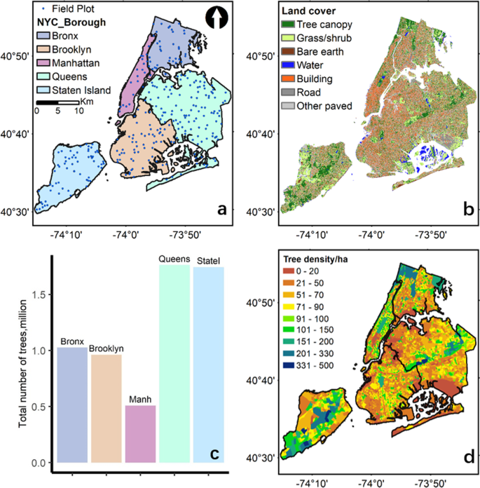
Individual tree structure mapping in cities is important for urban environmental studies. Despite mapping products for tree canopy cover and biomass are reported at multiple spatial scales using various approaches, spatially explicit mapping of individual trees and their three-dimensional structure is sparse. Here we produced an individual tree dataset including tree locations, height, crown area, crown volume, and biomass over the entire New York City, USA for 6,005,690 trees. Individual trees were detected and mapped from remotely sensed datasets along with their height and crown size information. Tree biomass in 296 field plots was measured and modelled using i-Tree Eco. Wall-to-wall tree biomass was mapped using relationships between field measurements and remotely sensed datasets and downscaled to individual trees. Validation using field-plot measurements indicated that our mapping products overestimated tree number, mean tree height and maximum tree height by 11.1%, 8.6%, and 5.3%, respectively. These overestimations were mainly due to the spatial and temporal mis-match between field measurements and remote sensing observations and uncertainties in tree segmentation algorithms. This dataset enables the evaluation of urban forest ecosystem services including regulating urban heat and promoting urban health, which can provide valuable insights for urban forest management and policy making.
中文翻译:
为美国纽约市绘制超过 600 万棵树的个体结构图
城市中的个体树结构图对于城市环境研究很重要。尽管使用各种方法在多个空间尺度上报告了树冠覆盖和生物量的绘图产品,但单个树木及其三维结构的空间显式绘图很少。在这里,我们为 6,005,690 棵树生成了一个单独的树木数据集,包括整个美国纽约市的树木位置、高度、树冠面积、树冠体积和生物量。从遥感数据集中检测并绘制了单棵树及其高度和树冠大小信息。使用 i-Tree Eco 测量并模拟了 296 个田间地块中的树木生物量。使用现场测量和遥感数据集之间的关系绘制墙到墙的树木生物量,并缩小到单个树木。使用现场图测量进行的验证表明,我们的制图产品高估了树数、平均树高和最大树高,分别高估了 11.1%、8.6% 和 5.3%。这些高估主要是由于实地测量和遥感观测之间的空间和时间不匹配以及树木分割算法中的不确定性。该数据集可以评估城市森林生态系统服务,包括调节城市热量和促进城市健康,这可以为城市森林管理和政策制定提供有价值的见解。这些高估主要是由于实地测量和遥感观测之间的空间和时间不匹配以及树木分割算法中的不确定性。该数据集可以评估城市森林生态系统服务,包括调节城市热量和促进城市健康,这可以为城市森林管理和政策制定提供有价值的见解。这些高估主要是由于实地测量和遥感观测之间的空间和时间不匹配以及树木分割算法中的不确定性。该数据集可以评估城市森林生态系统服务,包括调节城市热量和促进城市健康,这可以为城市森林管理和政策制定提供有价值的见解。


 京公网安备 11010802027423号