Precision Agriculture ( IF 5.4 ) Pub Date : 2023-02-08 , DOI: 10.1007/s11119-023-09989-5 Ladan Heydari , Hossein Bayat , Annamaria Castrignanò
|
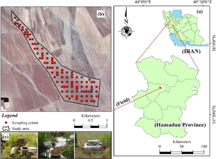
Assessing and modelling within-field variability of crop and soil at different scales is a pre-requisite for effective management in Precision Agriculture. Actually, site-specific agronomic management cannot disregard knowledge of the associated scale(s) of the phenomena occurring in the soil and plant that a farmer wishes to control. A partition of the field into management zones has then to be scale-dependent because it may vary as a result of scaling. The objective of this study was to construct a scale-dependent model of spatial soil-crop relationships by using a multivariate geostatistical approach for producing field partition at the relevant scales. Some soil attributes and confined compression function parameters, photosynthetic parameters and wheat yields were determined at 100 locations on a regular grid (150 m × 150 m) covering the whole field area (200 ha). A nested linear model of coregionalization was estimated and a Factorial cokriging analysis was performed to model the multivariate correlation structure and calculate regionalized factors at three different scales. The retained regionalized factors were: the first factor at 545 m scale, showing greater spatial correlation with yield parameters; the second factor at the same scale, more correlated with plant photosynthetic parameter and mechanical properties of soil; the first longer-scale factor, which might be interpreted as an inverse indicator of soil compaction. It was more related to variables clay and bulk density that can be assumed stationary at a scale extending beyond the actual size of the field. Each of these three factors produced a different partition of the field, each of which could be used for different purposes and to manage distinct agronomic operations. The results showed the complexity of the soil-crop interactions due to the influence of distinct sources of variation working on several spatial scales. The multi-scale delineation of the field in homogeneous zones emphasises the need not to neglect the scale associated with agronomic operations, in order to increase the effectiveness of site-specific management.
中文翻译:
基于精准农业的作物-土壤关系的尺度相关地质统计模型
对不同规模的作物和土壤的田间变异性进行评估和建模是精准农业有效管理的先决条件。实际上,特定地点的农艺管理不能忽视对农民希望控制的土壤和植物中发生的现象的相关规模的了解。将油田划分为管理区域必须依赖于规模,因为它可能会因规模而变化。本研究的目的是通过使用多变量地质统计方法在相关尺度上生成田地分区,构建空间土壤-作物关系的尺度依赖模型。一些土属性和受限压缩函数参数,在覆盖整个田地面积(200 公顷)的规则网格(150 米×150 米)上的 100 个位置确定了光合参数和小麦产量。估计了共区域化的嵌套线性模型,并进行了析因协同克里金分析,以对多变量相关结构进行建模,并计算三个不同尺度的区域化因子。保留的区域化因子为:第一个因子在 545 m 尺度上,与产量参数表现出更大的空间相关性;第二个因子在同尺度下,与植物光合参数和土壤力学性质的相关性更高;第一个较长尺度的因子,可以解释为土壤压实的逆向指标。它更多地与变量粘土和体积密度有关,这些变量可以假设在超出油田实际大小的范围内保持静止。这三个因素中的每一个都产生了不同的田地划分,每一个都可以用于不同的目的和管理不同的农艺操作。结果表明,由于在多个空间尺度上工作的不同变异源的影响,土壤与作物相互作用的复杂性。同质区田地的多尺度划定强调不能忽视与农艺操作相关的尺度,以提高特定地点管理的有效性。结果表明,由于在多个空间尺度上工作的不同变异源的影响,土壤与作物相互作用的复杂性。同质区田地的多尺度划定强调不能忽视与农艺操作相关的尺度,以提高特定地点管理的有效性。结果表明,由于在多个空间尺度上工作的不同变异源的影响,土壤与作物相互作用的复杂性。同质区田地的多尺度划定强调不能忽视与农艺操作相关的尺度,以提高特定地点管理的有效性。


 京公网安备 11010802027423号