Precision Agriculture ( IF 5.4 ) Pub Date : 2022-12-29 , DOI: 10.1007/s11119-022-09982-4 Gal Rozenberg , José Luiz C. S. Dias , Wesley M. Anderson , Brent A. Sellers , Raoul K. Boughton , Matheus B. Piccolo , Lior Blank
|
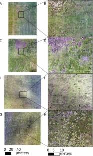
Grasses within the Sporobolus genus have been classified as problematic weeds of pastures in many countries. In Florida, giant smutgrass is the most common and troublesome weedy Sporobolus grass. The use of unmanned aerial vehicles (UAVs) for mapping, combined with site-specific weed control has the potential to optimize giant smutgrass management and decrease the use of herbicides. In this research, RGB ortho-mosaics captured from a simple UAV were examined to detect and map giant smutgrass in bahiagrass pastures in Florida. Two sampling dates (May and August) and four flight altitudes (50, 75, 100 and 120 m) were investigated for optimal classification accuracy. Spectral, texture and combined (spectral and texture) analyses served as the basis for supervised (random forest) and unsupervised (k means) classifications. Giant smutgrass cover was successfully mapped and best evaluated by integrating the combined analysis with supervised algorithm, reaching a correlation of 0.91 with the ground truth cover. Flight altitude had a negative relationship with giant smutgrass detection; however, satisfactory results were also obtained from 120 m with an average correlation of 0.76 when using combined supervised classification. Additionally, both sampling dates were found adequate for giant smutgrass mapping. These findings demonstrate that low-cost UAV platforms can successfully be used to generate accurate giant smutgrass infestations maps, allowing for site-specific management in bahiagrass pastures. Results from this work also broaden the general knowledge on the impacts that different settings and parameters (e.g. time of the year, altitude and image-analyses methods) can have on aerial image classification.
中文翻译:
使用低成本无人机绘制巴伊亚草牧场的巨型黑穗草
在许多国家,孢子草属的草已被归类为有问题的牧场杂草。在佛罗里达州,巨型黑穗草是最常见和最麻烦的杂草孢子草属草。使用无人驾驶飞行器 (UAV) 进行测绘,结合特定地点的杂草控制,有可能优化巨型黑穗草管理并减少除草剂的使用。在这项研究中,检查了从简单的无人机捕获的 RGB 正射马赛克,以检测和绘制佛罗里达州巴伊亚草牧场中的巨型黑穗草。研究了两个采样日期(5 月和 8 月)和四个飞行高度(50、75、100 和 120 m)以获得最佳分类精度。光谱、纹理和组合(光谱和纹理)分析作为监督(随机森林)和无监督(k 均值)分类的基础。通过将组合分析与监督算法相结合,成功绘制了巨型黑穗草覆盖物并对其进行了最佳评估,与地面真实覆盖物的相关性达到 0.91。飞行高度与巨型黑穗草检测呈负相关;然而,当使用组合监督分类时,从 120 m 也获得了令人满意的结果,平均相关性为 0.76。此外,发现两个采样日期都适合巨型黑穗草测绘。这些发现表明,低成本的无人机平台可以成功地用于生成准确的巨型黑穗草侵扰地图,从而允许在巴伊亚草牧场进行特定地点的管理。这项工作的结果还拓宽了关于不同设置和参数(例如一年中的时间、高度和图像分析方法)可能对航拍图像分类产生的影响的一般知识。使用联合监督分类时为 76。此外,发现两个采样日期都适合巨型黑穗草测绘。这些发现表明,低成本的无人机平台可以成功地用于生成准确的巨型黑穗草侵扰地图,从而允许在巴伊亚草牧场进行特定地点的管理。这项工作的结果还拓宽了关于不同设置和参数(例如一年中的时间、高度和图像分析方法)可能对航拍图像分类产生的影响的一般知识。使用联合监督分类时为 76。此外,发现两个采样日期都适合巨型黑穗草测绘。这些发现表明,低成本的无人机平台可以成功地用于生成准确的巨型黑穗草侵扰地图,从而允许在巴伊亚草牧场进行特定地点的管理。这项工作的结果还拓宽了关于不同设置和参数(例如一年中的时间、高度和图像分析方法)可能对航拍图像分类产生的影响的一般知识。允许在巴伊亚草牧场进行特定地点的管理。这项工作的结果还拓宽了关于不同设置和参数(例如一年中的时间、高度和图像分析方法)可能对航拍图像分类产生的影响的一般知识。允许在巴伊亚草牧场进行特定地点的管理。这项工作的结果还拓宽了关于不同设置和参数(例如一年中的时间、高度和图像分析方法)可能对航拍图像分类产生的影响的一般知识。


 京公网安备 11010802027423号