Nature ( IF 50.5 ) Pub Date : 2022-11-16 , DOI: 10.1038/s41586-022-05315-7 Jeroen C J Koelemeij 1 , Han Dun 2 , Cherif E V Diouf 2 , Erik F Dierikx 3 , Gerard J M Janssen 2 , Christian C J M Tiberius 2
|
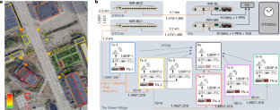
Global navigation satellite systems (GNSS) are widely used for navigation and time distribution1,2,3, features that are indispensable for critical infrastructure such as mobile communication networks, as well as emerging technologies such as automated driving and sustainable energy grids3,4. Although GNSS can provide centimetre-level precision, GNSS receivers are prone to many-metre errors owing to multipath propagation and an obstructed view of the sky, which occur particularly in urban areas where accurate positioning is most needed1,5,6. Moreover, the vulnerabilities of GNSS, combined with the lack of a back-up system, pose a severe risk to GNSS-dependent technologies7. Here we demonstrate a terrestrial positioning system that is independent of GNSS and offers superior performance through a constellation of radio transmitters, connected and time-synchronized at the subnanosecond level through a fibre-optic Ethernet network8. Using optical and wireless transmission schemes similar to those encountered in mobile communication networks, and exploiting spectrally efficient virtual wideband signals, the detrimental effects of multipath propagation are mitigated9, thus enabling robust decimetre-level positioning and subnanosecond timing in a multipath-prone outdoor environment. This work provides a glimpse of a future in which telecommunication networks provide not only connectivity but also GNSS-independent timing and positioning services with unprecedented accuracy and reliability.
中文翻译:
用于分米级地面定位的混合光无线网络
全球导航卫星系统 (GNSS) 广泛用于导航和时间分配1,2,3,这些功能对于移动通信网络等关键基础设施以及自动驾驶和可持续能源网络3,4等新兴技术必不可少. 尽管 GNSS 可以提供厘米级的精度,但由于多径传播和天空视野受阻,GNSS 接收器容易出现数米级的误差,这种情况尤其发生在最需要精确定位的城市地区1,5,6。此外,GNSS 的脆弱性,加上缺乏备份系统,对依赖 GNSS 的技术构成严重风险7. 在这里,我们展示了一个独立于 GNSS 的地面定位系统,并通过无线电发射机星座提供卓越的性能,通过光纤以太网网络8在亚纳秒级连接和时间同步。使用类似于移动通信网络中遇到的光学和无线传输方案,并利用频谱高效的虚拟宽带信号,可以减轻多径传播的不利影响9,从而在多路径多发的室外环境中实现稳健的分米级定位和亚纳秒级定时。这项工作提供了一个未来的一瞥,在这个未来中,电信网络不仅提供连通性,还提供独立于 GNSS 的定时和定位服务,具有前所未有的准确性和可靠性。


 京公网安备 11010802027423号