Climate Dynamics ( IF 3.8 ) Pub Date : 2022-09-19 , DOI: 10.1007/s00382-022-06480-1 Rondrotiana Barimalala , Rachel James , Callum Munday , Chris J. C. Reason
|
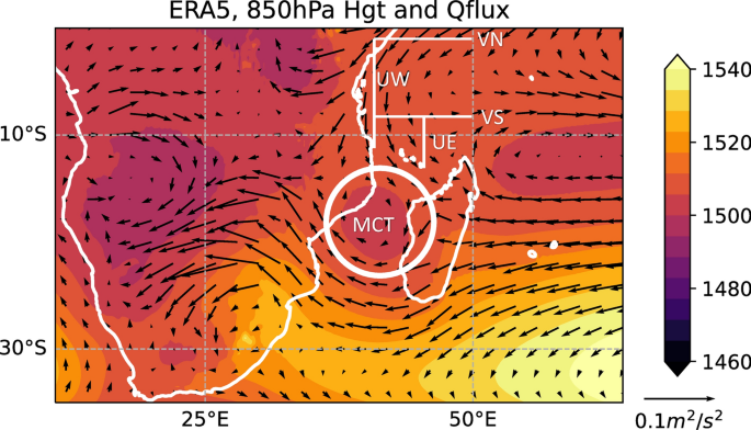
The topography of Madagascar and the strength of the Mozambique Channel Trough (MCT) modulate summer rainfall over southern Africa. A strong MCT hinders the penetration of moisture bearing easterlies from the South Indian Ocean into the mainland, thus reducing rainfall there and vice versa for weak MCT summers. Given the link between the MCT and rainfall, it is important to analyse how climate models represent the trough. Here, output from 20 models within the CMIP6 ensemble of Coupled General Circulation Models (CGCMs) are analyzed to investigate how state-of-the-art CGCMs represent the MCT and its link to southern African rainfall. Overall, the ensemble mean insignificantly underestimates the observed MCT. There is a large spread among the models, with the strength of the MCT significantly correlated with the Froude number based on the mountain height over Madagascar. In models, the vorticity tendency in the MCT area is dominated by the stretching and friction terms, whereas the vertical advection, tilting and residual terms dominate in the ERA5 reanalysis. The link between MCT and rainfall in the southern African subcontinent is missing in the models. Large rainfall biases are depicted over mainland even in models with a very strong MCT. It is found that the impacts of the MCT in the models could be masked by a complex mix of processes such as the strength of the Angola low, moisture fluxes from the Indian and South Atlantic Oceans as well as overestimated convection in the Mozambique Channel area.
中文翻译:
CMIP6 模型中莫桑比克水槽的表示及其与南部非洲降雨的联系
马达加斯加的地形和莫桑比克海峡槽 (MCT) 的强度调节了南部非洲的夏季降雨量。强烈的 MCT 阻碍了从南印度洋向东渗透到大陆的湿气,从而减少了那里的降雨量,反之亦然,对于 MCT 较弱的夏季。鉴于 MCT 和降雨之间的联系,分析气候模型如何代表低谷非常重要。在这里,对 CMIP6 耦合环流模型 (CGCM) 集合中 20 个模型的输出进行分析,以研究最先进的 CGCM 如何代表 MCT 及其与南部非洲降雨的联系。总体而言,整体平均值微不足道地低估了观察到的 MCT。模型之间的分布很大,MCT 的强度与基于马达加斯加山高的弗劳德数显着相关。在模型中,MCT 区域的涡度趋势以拉伸和摩擦项为主,而 ERA5 再分析则以垂直平流、倾斜和残余项为主。模型中缺少 MCT 与南部非洲次大陆降雨之间的联系。即使在具有非常强 MCT 的模型中,也会在大陆上描绘出大的降雨偏差。研究发现,模型中 MCT 的影响可能被复杂的混合过程所掩盖,例如安哥拉低压的强度、来自印度洋和南大西洋的水分通量以及高估莫桑比克海峡地区的对流。MCT区域的涡度趋势以拉伸和摩擦项为主,而ERA5再分析则以垂直平流、倾斜和残余项为主。模型中缺少 MCT 与南部非洲次大陆降雨之间的联系。即使在具有非常强 MCT 的模型中,也会在大陆上描绘出大的降雨偏差。研究发现,模型中 MCT 的影响可能被复杂的混合过程所掩盖,例如安哥拉低压的强度、来自印度洋和南大西洋的水分通量以及高估莫桑比克海峡地区的对流。MCT区域的涡度趋势以拉伸和摩擦项为主,而ERA5再分析则以垂直平流、倾斜和残余项为主。模型中缺少 MCT 与南部非洲次大陆降雨之间的联系。即使在具有非常强 MCT 的模型中,也会在大陆上描绘出大的降雨偏差。研究发现,模型中 MCT 的影响可能被复杂的混合过程所掩盖,例如安哥拉低压的强度、来自印度洋和南大西洋的水分通量以及高估莫桑比克海峡地区的对流。即使在具有非常强 MCT 的模型中,也会在大陆上描绘出大的降雨偏差。研究发现,模型中 MCT 的影响可能被复杂的混合过程所掩盖,例如安哥拉低压的强度、来自印度洋和南大西洋的水分通量以及高估莫桑比克海峡地区的对流。即使在具有非常强 MCT 的模型中,也会在大陆上描绘出大的降雨偏差。研究发现,模型中 MCT 的影响可能被复杂的混合过程所掩盖,例如安哥拉低压的强度、来自印度洋和南大西洋的水分通量以及高估莫桑比克海峡地区的对流。


 京公网安备 11010802027423号