Journal of Geodesy ( IF 3.9 ) Pub Date : 2022-08-13 , DOI: 10.1007/s00190-022-01646-5 Yufeng Hu , Ji Wang , Zhenhong Li , Jianbing Peng
|
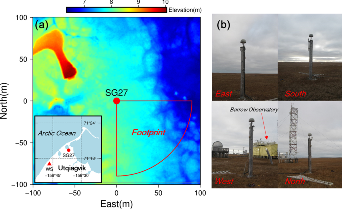
Ground subsidence and uplift caused by the annual thawing and freezing of the active layer are important variables in permafrost studies. Global positioning system interferometric reflectometry (GPS-IR) has been successfully applied to retrieve the continuous ground surface movements in permafrost areas. However, only GPS signals were used in previous studies. In this study, using multiple global navigation satellite system (GNSS) signal-to-noise ratio (SNR) observations recorded by a GNSS station SG27 in Utqiaġvik, Alaska during the period from 2018 to 2021, we applied multiple GNSS-IR (multi-GNSS-IR) technique to the SNR data and obtained the complete and continuous ground surface elevation changes over the permafrost area at a daily interval in snow-free seasons in 2018 and 2019. The GLONASS-IR and Galileo-IR measurements agreed with the GPS-IR measurements at L1 frequency, which are the most consistent measurements among all multi-GNSS measurements, in terms of the overall subsidence trend but clearly showed periodic noises. We proposed a method to reconstruct the GLONASS- and Galileo-IR elevation changes by specifically grouping and fitting them with a composite model. Compared with GPS L1 results, the unbiased root mean square error (RMSE) of the reconstructed Galileo measurements reduced by 50.0% and 42.2% in 2018 and 2019, respectively, while the unbiased RMSE of the reconstructed GLONASS measurements decreased by 41.8% and 25.8% in 2018 and 2019, respectively. Fitting the composite model to the combined multi-GNSS-IR, we obtained seasonal displacements of − 3.27 ± 0.13 cm (R2 = 0.763) and − 10.56 ± 0.10 cm (R2 = 0.912) in 2018 and 2019, respectively. Moreover, we found that the abnormal summer heave was strongly correlated with rain events, implying hydrological effects on the ground surface elevation changes. Our study shows the feasibility of multi-GNSS-IR in permafrost areas for the first time. Multi-GNSS-IR opens up a great opportunity for us to investigate ground surface movements over permafrost areas with multi-source observations, which are important for our robust analysis and quantitative understanding of frozen ground dynamics under climate change.
中文翻译:
多个 GNSS 干涉反射仪揭示多年冻土区地表高程变化
活动层每年的解冻和冻结引起的地面沉降和隆升是多年冻土研究的重要变量。全球定位系统干涉反射计(GPS-IR)已成功应用于反演多年冻土区的连续地表运动。然而,在以前的研究中只使用了 GPS 信号。在本研究中,利用 2018 年至 2021 年期间阿拉斯加乌特恰维克的 GNSS 台站 SG27 记录的多个全球导航卫星系统 (GNSS) 信噪比 (SNR) 观测数据,我们应用了多个 GNSS-IR (multi- GNSS-IR) 技术对 SNR 数据进行了分析,获得了 2018 年和 2019 年无雪季节每日间隔的多年冻土区完整连续的地表高程变化。就整体沉降趋势而言,GLONASS-IR 和 Galileo-IR 测量结果与 L1 频率的 GPS-IR 测量结果一致,这是所有多 GNSS 测量结果中最一致的测量结果,但明显显示出周期性噪声。我们提出了一种方法来重建 GLONASS 和 Galileo-IR 高程变化,具体方法是使用复合模型对它们进行分组和拟合。与 GPS L1 结果相比,2018 年和 2019 年重建的伽利略测量的无偏均方根误差 (RMSE) 分别降低了 50.0% 和 42.2%,而重建的 GLONASS 测量的无偏均方根误差 (RMSE) 分别降低了 41.8% 和 25.8%分别在 2018 年和 2019 年。将复合模型拟合到组合的多 GNSS-IR,我们获得了 - 3.27 ± 0.13 cm 的季节性位移(就整体沉降趋势而言,这是所有多 GNSS 测量中最一致的测量,但明显显示出周期性噪声。我们提出了一种方法来重建 GLONASS 和 Galileo-IR 高程变化,具体方法是使用复合模型对它们进行分组和拟合。与 GPS L1 结果相比,2018 年和 2019 年重建的伽利略测量的无偏均方根误差 (RMSE) 分别降低了 50.0% 和 42.2%,而重建的 GLONASS 测量的无偏均方根误差 (RMSE) 分别降低了 41.8% 和 25.8%分别在 2018 年和 2019 年。将复合模型拟合到组合的多 GNSS-IR,我们获得了 - 3.27 ± 0.13 cm 的季节性位移(就整体沉降趋势而言,这是所有多 GNSS 测量中最一致的测量,但明显显示出周期性噪声。我们提出了一种方法来重建 GLONASS 和 Galileo-IR 高程变化,具体方法是使用复合模型对它们进行分组和拟合。与 GPS L1 结果相比,2018 年和 2019 年重建的伽利略测量的无偏均方根误差 (RMSE) 分别降低了 50.0% 和 42.2%,而重建的 GLONASS 测量的无偏均方根误差 (RMSE) 分别降低了 41.8% 和 25.8%分别在 2018 年和 2019 年。将复合模型拟合到组合的多 GNSS-IR,我们获得了 - 3.27 ± 0.13 cm 的季节性位移(我们提出了一种方法来重建 GLONASS 和 Galileo-IR 高程变化,具体方法是使用复合模型对它们进行分组和拟合。与 GPS L1 结果相比,2018 年和 2019 年重建的伽利略测量的无偏均方根误差 (RMSE) 分别降低了 50.0% 和 42.2%,而重建的 GLONASS 测量的无偏均方根误差 (RMSE) 分别降低了 41.8% 和 25.8%分别在 2018 年和 2019 年。将复合模型拟合到组合的多 GNSS-IR,我们获得了 - 3.27 ± 0.13 cm 的季节性位移(我们提出了一种方法来重建 GLONASS 和 Galileo-IR 高程变化,具体方法是使用复合模型对它们进行分组和拟合。与 GPS L1 结果相比,2018 年和 2019 年重建的伽利略测量的无偏均方根误差 (RMSE) 分别降低了 50.0% 和 42.2%,而重建的 GLONASS 测量的无偏均方根误差 (RMSE) 分别降低了 41.8% 和 25.8%分别在 2018 年和 2019 年。将复合模型拟合到组合的多 GNSS-IR,我们获得了 - 3.27 ± 0.13 cm 的季节性位移(2018 年和 2019 年分别下降了 2%,而 GLONASS 重建测量的无偏 RMSE 在 2018 年和 2019 年分别下降了 41.8% 和 25.8%。将复合模型拟合到组合的多 GNSS-IR,我们获得了 - 3.27 ± 0.13 cm 的季节性位移(2018 年和 2019 年分别下降了 2%,而 GLONASS 重建测量的无偏 RMSE 在 2018 年和 2019 年分别下降了 41.8% 和 25.8%。将复合模型拟合到组合的多 GNSS-IR,我们获得了 - 3.27 ± 0.13 cm 的季节性位移(2018 年和 2019 年分别为R 2 = 0.763) 和 − 10.56 ± 0.10 cm ( R 2 = 0.912)。此外,我们发现异常的夏季隆起与降雨事件密切相关,这意味着水文对地表高程变化的影响。我们的研究首次展示了多 GNSS-IR 在永久冻土区的可行性。Multi-GNSS-IR 为我们提供了一个很好的机会,通过多源观测研究永久冻土区的地表运动,这对于我们对气候变化下冻土动力学的稳健分析和定量理解非常重要。


 京公网安备 11010802027423号