Remote Sensing of Environment ( IF 11.1 ) Pub Date : 2022-08-09 , DOI: 10.1016/j.rse.2022.113202 Zhongyang Hu , Peter Kuipers Munneke , Stef Lhermitte , Mariel Dirscherl , Chaonan Ji , Michiel van den Broeke
|
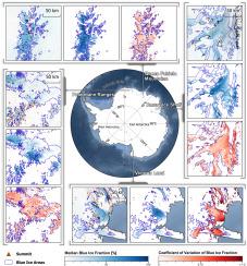
Antarctic blue ice areas are exposed due to erosion and sublimation of snow. At the same time, surface melt can form surface types that are spectrally similar to blue ice, especially at low elevations. These are termed melt-induced blue ice areas. Both types of blue ice are sensitive indicators of climate change. Satellite remote sensing is a powerful technique to retrieve the spatial extent of blue ice areas and their variation in time. Yet, existing satellite-derived blue ice area products are either mono-temporal for the entire Antarctic ice sheet, or multi-temporal for a limited area. Here, we present FABIAN, a product of blue ice fraction over Antarctica, derived from the moderate resolution imaging spectroradiometer (MODIS) archive covering the period 2000–2021. A spectral mixture analysis (SMA) in Google Earth Engine, based on a careful selection of endmember spectra, accurately reconstructs the reflectance observed by MODIS in blue ice areas. Based on a validation with contemporaneous Sentinel-2 images, FABIAN has a root mean square error in blue ice fraction of approximately 10% ∼ 20% in wind-induced blue ice areas, and 20% ∼ 30% in melt-induced blue ice areas across six selected test sites in the coastal East Antarctic ice sheet. FABIAN is challenged in regions with shallow melt streams and lakes, since their spectral profiles are similar to those from blue ice areas in MODIS bands. For further analyses and applications, FABIAN holds the potential for (1) deriving annual blue ice area maps, (2) distinguishing between wind-and melt-induced blue ice types, (3) evaluating and correcting (regional) climate models, and (4) analyzing temporal variations in blue ice abundance and exposure.
中文翻译:
FABIAN:基于使用谷歌地球引擎的 MODIS 图像,2000 年至 2021 年间南极洲上空的部分南夏季蓝冰的每日产品
由于雪的侵蚀和升华,南极蓝冰区暴露在外。同时,地表融化可以形成光谱上类似于蓝冰的表面类型,尤其是在低海拔地区。这些被称为融化诱导的蓝冰区。这两种蓝冰都是气候变化的敏感指标。卫星遥感是一种强大的技术,可用于检索蓝冰区的空间范围及其随时间的变化。然而,现有的卫星衍生蓝冰区产品要么是整个南极冰盖的单时相产品,要么是有限区域的多时相产品。在这里,我们展示了 FABIAN,它是南极洲上空蓝冰部分的产物,源自 2000-2021 年期间的中等分辨率成像光谱仪 (MODIS) 档案。Google Earth Engine 中的光谱混合分析 (SMA),基于对端元光谱的仔细选择,准确地重建了 MODIS 在蓝色冰区观察到的反射率。基于对同时期 Sentinel-2 图像的验证,FABIAN 在风致蓝冰区域的蓝冰分数的均方根误差约为 10% ∼ 20%,在融化导致的蓝冰区域中约为 20% ∼ 30%横跨南极东部沿海冰盖的六个选定测试地点。FABIAN 在具有浅熔流和湖泊的地区受到挑战,因为它们的光谱剖面类似于 MODIS 波段的蓝色冰区的光谱剖面。对于进一步的分析和应用,FABIAN 具有以下潜力:(1)导出年度蓝冰面积图,(2)区分风和融化引起的蓝冰类型,(3)评估和校正(区域)气候模型,


 京公网安备 11010802027423号