当前位置:
X-MOL 学术
›
Hydrol. Process.
›
论文详情
Our official English website, www.x-mol.net, welcomes your
feedback! (Note: you will need to create a separate account there.)
Combining sediment source tracing techniques with traditional monitoring: The “Arvorezinha catchment” experience
Hydrological Processes ( IF 2.8 ) Pub Date : 2022-08-09 , DOI: 10.1002/hyp.14665 Jean P. G. Minella 1 , Gustavo H. Merten 2 , Alexandre Schlesner 1 , Felipe Bernardi 1 , Cláudia A. P. de Barros 3 , Tales Tiecher 3 , Rafael Ramon 4 , Olivier Evrard 5 , Danilo Rheinheimer dos Santos 1 , José Miguel Reichert 1 , Rutineia Tassi 6
Hydrological Processes ( IF 2.8 ) Pub Date : 2022-08-09 , DOI: 10.1002/hyp.14665 Jean P. G. Minella 1 , Gustavo H. Merten 2 , Alexandre Schlesner 1 , Felipe Bernardi 1 , Cláudia A. P. de Barros 3 , Tales Tiecher 3 , Rafael Ramon 4 , Olivier Evrard 5 , Danilo Rheinheimer dos Santos 1 , José Miguel Reichert 1 , Rutineia Tassi 6
Affiliation
|
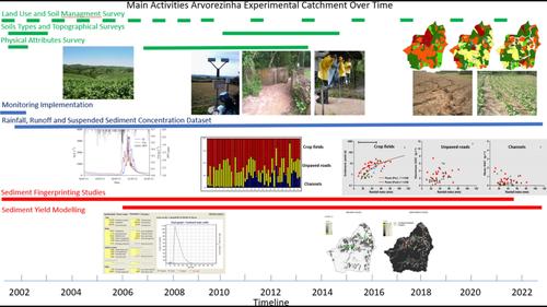
To truly understand the hydrologic and erosive processes that occur at the catchment scale regarding land use and soil management changes, intensive monitoring is required over a long period. Variables such as precipitation, flow rate and suspended sediment concentration are the fundamentals needed to estimate sediment yield (SY). However, in order to shed more light on the effects of soil management changes on SY, traditional hydrologic monitoring techniques can be paired with sediment tracing to identify sediment sources. In addition, mathematical models that predict erosion and SY can also help understand the dynamics of erosion and deposition between the hillslope and stream channel. Given the above, this article provides an overview of almost 20 years of monitoring (2002–2021) in the Arvorezinha experimental catchment (1.23 km2) located on the edge of the Brazilian meridional plateau in southern Brazil, which is subject to extreme erosion due to a combination of factors related to intensive agriculture and steep slopes. The catchment was selected as a study site to evaluate the effects of land-use changes and soil conservation management on hydrology and SY. The text reviews the history of the study, synthesizes the main results and describes the evolution of the monitoring techniques used while giving special attention to the fingerprinting approach. In addition, the article discusses the importance of catchment-scale studies for teaching, generating technical-scientific knowledge and fostering collaboration between national and international research groups.
中文翻译:

将沉积物溯源技术与传统监测相结合:“Arvorezinha 集水区”体验
为了真正了解流域范围内发生的有关土地利用和土壤管理变化的水文和侵蚀过程,需要长期进行密集监测。降水量、流速和悬浮泥沙浓度等变量是估算泥沙产量 (SY) 所需的基础。然而,为了更清楚地了解土壤管理变化对 SY 的影响,传统的水文监测技术可以与沉积物追踪相结合,以识别沉积物来源。此外,预测侵蚀和 SY 的数学模型还可以帮助了解山坡和河道之间的侵蚀和沉积动态。鉴于上述情况,本文概述了 Arvorezinha 实验集水区(1.23 公里)近 20 年的监测(2002-2021 年)2 ) 位于巴西南部的巴西经向高原边缘,由于集约农业和陡坡等因素的综合作用,该地区受到极端侵蚀。选择流域作为研究地点,评估土地利用变化和水土保持管理对水文和 SY 的影响。文本回顾了这项研究的历史,综合了主要结果并描述了所使用的监测技术的演变,同时特别关注了指纹方法。此外,本文还讨论了流域规模研究对于教学、产生技术科学知识以及促进国家和国际研究小组之间合作的重要性。
更新日期:2022-08-09
中文翻译:
将沉积物溯源技术与传统监测相结合:“Arvorezinha 集水区”体验
为了真正了解流域范围内发生的有关土地利用和土壤管理变化的水文和侵蚀过程,需要长期进行密集监测。降水量、流速和悬浮泥沙浓度等变量是估算泥沙产量 (SY) 所需的基础。然而,为了更清楚地了解土壤管理变化对 SY 的影响,传统的水文监测技术可以与沉积物追踪相结合,以识别沉积物来源。此外,预测侵蚀和 SY 的数学模型还可以帮助了解山坡和河道之间的侵蚀和沉积动态。鉴于上述情况,本文概述了 Arvorezinha 实验集水区(1.23 公里)近 20 年的监测(2002-2021 年)2 ) 位于巴西南部的巴西经向高原边缘,由于集约农业和陡坡等因素的综合作用,该地区受到极端侵蚀。选择流域作为研究地点,评估土地利用变化和水土保持管理对水文和 SY 的影响。文本回顾了这项研究的历史,综合了主要结果并描述了所使用的监测技术的演变,同时特别关注了指纹方法。此外,本文还讨论了流域规模研究对于教学、产生技术科学知识以及促进国家和国际研究小组之间合作的重要性。


 京公网安备 11010802027423号