Journal of Hydrology ( IF 5.9 ) Pub Date : 2022-08-05 , DOI: 10.1016/j.jhydrol.2022.128278 Alcindo Neckel , Marcos L.S. Oliveira , Guilherme L. Dotto , Laércio Stolfo Maculan , Brian William Bodah , Luis F.O. Silva
|
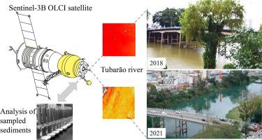
Globally, hydrographic basins are routinely contaminated by anthropogenic contaminants originating from coal mining, swine farming, urban sewage, pesticide use, and other various sources. These contaminants not only spread pollution but also nanoparticles (NPs) capable of contaminating the fauna and flora of estuaries in addition to being harmful to human health. The use of images from the Sentinel-3B OLCI (Ocean Land Color Instrument) satellite makes it possible to obtain spectral data aimed at identifying the presence of possible contamination in large regions, which can be complemented by advanced electron microscopies. The general objective of this study is to analyze the dispersion of NPs and ultrafine particles (UFPs) in a region that contains multiple contaminants through the use of images from the Sentinel-3B OLCI satellite. The authors examined images taken after two particularly intense tropical rain events in December 2018 and 2021, in the region of the Laguna estuary located in the Brazilian state of Santa Catarina. Suspended sediments (SSs) were collected from seventeen points on the Tubarão River in 2018. These samples were then submitted to an analytical laboratory for various analyses such as X-ray Diffraction (XRD), and transmission and scanning electron microscopes. Additionally, images from the Sentinel-3B satellite OLCI in the Laguna estuary region from 2018 and 2021 were analyzed based on the following variables: water turbidity (TSM_NN), chlorophyll-a (CHL_NN) and suspended pollution potential (ADG_443_NN). The SSs demonstrated the presence of massive crystals of ultrafine pyrite in a pseudomorph crystal of jarosite containing nanospheres with hazardous elements (e.g. As, Hg, Cd and Pb), which represent important pollutants. The Sentinel-3B OLCI images in relation to the variables TSM_NN, CHL_NN and ADG_443_NN (2018 and 2021), identified high turbidity in the waters of the Tubarão River. Analysis of SSs and satellite images are suitable for identifying contaminants toxic to the marine ecosystem and human health on a global scale.
中文翻译:
Sentinel-3B OLCI 卫星图像和海洋河口和流域纳米粒子分析的高级电子显微镜:关键污染物的稳健多分析和地理空间评估
在全球范围内,水文流域经常受到来自煤矿开采、养猪业、城市污水、杀虫剂使用和其他各种来源的人为污染物的污染。这些污染物不仅传播污染,而且纳米粒子(NPs)能够污染河口的动植物群,除了对人类健康有害。使用来自 Sentinel-3B OLCI(海洋陆地颜色仪器)卫星的图像可以获得旨在识别大区域可能存在污染的光谱数据,这可以通过先进的电子显微镜进行补充。本研究的总体目标是通过使用来自 Sentinel-3B OLCI 卫星的图像分析 NP 和超细颗粒 (UFP) 在包含多种污染物的区域中的分散情况。作者检查了 2018 年 12 月和 2021 年 12 月在巴西圣卡塔琳娜州的拉古纳河口地区发生两次特别强烈的热带雨事件后拍摄的图像。2018 年从 Tubarão 河的 17 个点收集了悬浮沉积物 (SS)。然后将这些样品提交给分析实验室进行各种分析,例如 X 射线衍射 (XRD)、透射和扫描电子显微镜。此外,基于以下变量分析了 2018 年和 2021 年拉古纳河口地区 Sentinel-3B 卫星 OLCI 的图像:水浊度 (TSM_NN)、叶绿素-a (CHL_NN) 和悬浮污染潜力 (ADG_443_NN)。SSs 证明了在黄钾铁矾假晶型晶体中存在大量超细黄铁矿晶体,其中含有具有危险元素(如 As、Hg、Cd 和 Pb)的纳米球,这些元素代表重要的污染物。Sentinel-3B OLCI 图像与变量 TSM_NN、CHL_NN 和 ADG_443_NN(2018 年和 2021 年)相关,确定了 Tubarão 河水域的高浊度。SSs 和卫星图像的分析适用于在全球范围内识别对海洋生态系统和人类健康有毒的污染物。


 京公网安备 11010802027423号