Russian Meteorology and Hydrology ( IF 1.4 ) Pub Date : 2022-07-26 , DOI: 10.3103/s1068373922040070 M. T. Abshaev , A. M. Abshaev , A. A. Sinkevich , Yu. P. Mikhailovskii , N. E. Veremei , V. N. Stasenko , A. Kh. Adzhiev , S. D. Pawar , V. Gopalakrishnan
|
Abstract
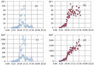
The development of a powerful supercell cloud is considered, from which large hail and a shower of catastrophic intensity have fallen for a long time. The analysis of radar and lightning-detection characteristics showed the presence of local extremes of intensity and currents of cloud-to-cloud and cloud-to-ground lightning discharges and allowed evaluating areas and intensities of hail, as well as cloud volumes with ice graupels of low and high density. The maximum values of thunderstorm characteristics occurred 1.5 hours after the mass and volume of the cloud with low-density graupels had reached their maxima. The maximum mass and volume of high-density graupels, the intensity and area of hail were reached approximately 2 hours later than the maximum thunderstorm characteristics.
中文翻译:
最大闪电活动阶段超级单体对流云的发展特征(2015年8月19日,北高加索)
摘要
考虑到强大的超级单体云的发展,长期以来,大冰雹和一场灾难性强度的阵雨已经从中落下。对雷达和闪电探测特性的分析表明存在局部极端强度和电流的云对云和云对地闪电放电,并允许评估冰雹的区域和强度,以及带有冰霰的云量低密度和高密度。雷暴特征的最大值出现在低密度霰云的质量和体积达到最大值后1.5小时。高密度霰的最大质量和体积、冰雹的强度和面积比最大雷暴特征晚约2小时。


 京公网安备 11010802027423号