Bulletin of Engineering Geology and the Environment ( IF 3.7 ) Pub Date : 2022-07-26 , DOI: 10.1007/s10064-022-02832-7 Shih-Jung Wang , Quoc Cuong Nguyen , Yu-Chen Lu , Yonatan Garkebo Doyoro , Duc-Huy Tran
|
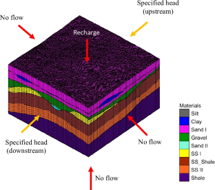
Uncertainty in hydrogeological modeling has recently received attention. It has been reported that the geological model is one of the primary sources of uncertainty. The present study developed a synthetic geological model (SGM) based on the geological characteristics in Taiwan as the baseline. Simulated geological models with various levels of data sufficiency were assessed based on multiple borehole numbers, with and without the incorporation of geological knowledge, and a combination of geophysical data with borehole data. The models were used in groundwater flow and land subsidence simulations. The results from the models were assessed and compared by calculating the root-mean-square error and coefficient of determination (R2) corresponding to SGM to evaluate the geological model uncertainty. The results show that a model based on data from 17 boreholes that incorporates geological knowledge for a 300 m × 300 m site provides an acceptable assessment of land subsidence. The geological model that incorporates geological knowledge extensively improves the numerical models, demonstrating that geological knowledge is necessary for deriving geological models. The model using geophysical data with correction based on data from at least 13 boreholes provided better results compared with those obtained using data from various numbers of boreholes or only geophysical data. This study demonstrates that additional data can significantly decrease the uncertainty in geological and numerical models. The results can be used by engineers and researchers to decide on a suitable strategy for engineering geology projects based on the precision requirements and budget. They can also help minimize risk when modelers and stakeholders make decisions.


 京公网安备 11010802027423号