当前位置:
X-MOL 学术
›
Remote Sens. Ecol. Conserv.
›
论文详情
Our official English website, www.x-mol.net, welcomes your
feedback! (Note: you will need to create a separate account there.)
Canopy palm cover across the Brazilian Amazon forests mapped with airborne LiDAR data and deep learning
Remote Sensing in Ecology and Conservation ( IF 3.9 ) Pub Date : 2022-07-22 , DOI: 10.1002/rse2.264 Ricardo Dalagnol 1, 2, 3 , Fabien H. Wagner 2, 3 , Thaise Emilio 4 , Annia S. Streher 1 , Lênio S. Galvão 1 , Jean P. H. B. Ometto 5 , Luiz E. O. C. Aragão 1, 6
Remote Sensing in Ecology and Conservation ( IF 3.9 ) Pub Date : 2022-07-22 , DOI: 10.1002/rse2.264 Ricardo Dalagnol 1, 2, 3 , Fabien H. Wagner 2, 3 , Thaise Emilio 4 , Annia S. Streher 1 , Lênio S. Galvão 1 , Jean P. H. B. Ometto 5 , Luiz E. O. C. Aragão 1, 6
Affiliation
|
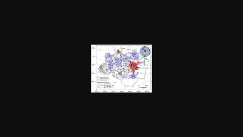
The Amazon region in Brazil contains c. 5% of the palm species of the world. However, palm cover at macroecological scales has not yet been quantified in this biome. Here, we used high spatial resolution LiDAR data, acquired from 610 flightlines over the Brazilian Amazon, to map canopy palm cover for the first time using a deep learning approach. The image segmentation model from U-Net deep learning was selected for mapping palm segments using the LiDAR canopy height model (CHM) at 0.5-m spatial resolution. To train and validate the model, we manually delineated 6971 canopy palm segments over 931.43 ha of forests on four training sites by inspecting their unique star-shaped crown architecture in the CHM. The results indicated an accuracy of 80% to automatically map canopy palm area. The approach detected >1.1 million palm segments over the 480 000 ha sampled by LiDAR and roughly estimated 1.05 billion palm segments for the Brazilian Amazon. Palm cover was not evenly distributed over the Amazon, revealing undocumented hotspots of high cover (>5%) in eastern Amazon (Pará state), and confirming documented hotspots in southwest (Acre state) and north of the region (Roraima state). Palm segment height was strongly and positively correlated with forest height, where palm segments showed overall lower height. A higher canopy palm cover was observed over shorter forests, while the opposite was found over taller forests, where palms may not be visible from the canopy. Palm segments occurred more frequently at valleys but they were also observed in other landscapes, depending on site location and forest height. Our findings highlight the disproportional occurrence of palm cover in some Amazonian canopies. This fact should be taken into account to improve regional carbon cycle representation and promote initiatives of biodiversity conservation and bioeconomic use of these forests.
中文翻译:

使用机载 LiDAR 数据和深度学习绘制的巴西亚马逊森林树冠覆盖
巴西的亚马逊地区包含 c。世界上5%的棕榈树种。然而,该生物群落中尚未量化宏观生态规模的棕榈覆盖率。在这里,我们使用从巴西亚马逊上空的 610 条航线获取的高空间分辨率 LiDAR 数据,首次使用深度学习方法绘制树冠棕榈覆盖图。选择来自 U-Net 深度学习的图像分割模型,使用 LiDAR 冠层高度模型 (CHM) 在 0.5 米空间分辨率下绘制手掌片段。为了训练和验证模型,我们通过检查 CHM 中独特的星形树冠结构,在四个训练地点的 931.43 公顷森林中手动描绘了 6971 个树冠棕榈段。结果表明,自动映射树冠棕榈区域的准确度为 80%。该方法检测到> 1。激光雷达在 48 万公顷的土地上采集了 100 万个棕榈段,巴西亚马逊地区大约有 10.5 亿个棕榈段。棕榈覆盖在亚马逊地区分布不均,揭示了亚马逊东部(帕拉州)未记录的高覆盖热点(> 5%),并确认了西南部(阿卡州)和该地区北部(罗赖马州)的记录热点。棕榈段高度与森林高度呈强正相关,其中棕榈段整体高度较低。在较短的森林中观察到较高的树冠棕榈覆盖,而在较高的森林中发现相反的情况,从树冠可能看不到棕榈树。棕榈段在山谷中更频繁地出现,但在其他景观中也观察到,这取决于场地位置和森林高度。我们的研究结果强调了一些亚马逊树冠中棕榈覆盖的不成比例。应该考虑到这一事实,以提高区域碳循环的代表性,并促进这些森林的生物多样性保护和生物经济利用的倡议。
更新日期:2022-07-22
中文翻译:
使用机载 LiDAR 数据和深度学习绘制的巴西亚马逊森林树冠覆盖
巴西的亚马逊地区包含 c。世界上5%的棕榈树种。然而,该生物群落中尚未量化宏观生态规模的棕榈覆盖率。在这里,我们使用从巴西亚马逊上空的 610 条航线获取的高空间分辨率 LiDAR 数据,首次使用深度学习方法绘制树冠棕榈覆盖图。选择来自 U-Net 深度学习的图像分割模型,使用 LiDAR 冠层高度模型 (CHM) 在 0.5 米空间分辨率下绘制手掌片段。为了训练和验证模型,我们通过检查 CHM 中独特的星形树冠结构,在四个训练地点的 931.43 公顷森林中手动描绘了 6971 个树冠棕榈段。结果表明,自动映射树冠棕榈区域的准确度为 80%。该方法检测到> 1。激光雷达在 48 万公顷的土地上采集了 100 万个棕榈段,巴西亚马逊地区大约有 10.5 亿个棕榈段。棕榈覆盖在亚马逊地区分布不均,揭示了亚马逊东部(帕拉州)未记录的高覆盖热点(> 5%),并确认了西南部(阿卡州)和该地区北部(罗赖马州)的记录热点。棕榈段高度与森林高度呈强正相关,其中棕榈段整体高度较低。在较短的森林中观察到较高的树冠棕榈覆盖,而在较高的森林中发现相反的情况,从树冠可能看不到棕榈树。棕榈段在山谷中更频繁地出现,但在其他景观中也观察到,这取决于场地位置和森林高度。我们的研究结果强调了一些亚马逊树冠中棕榈覆盖的不成比例。应该考虑到这一事实,以提高区域碳循环的代表性,并促进这些森林的生物多样性保护和生物经济利用的倡议。


 京公网安备 11010802027423号