Journal of Signal Processing Systems ( IF 1.6 ) Pub Date : 2022-07-23 , DOI: 10.1007/s11265-022-01777-0 Tanmay Kumar Behera , Sambit Bakshi , Pankaj Kumar Sa , Michele Nappi , Aniello Castiglione , Pandi Vijayakumar , Brij Bhooshan Gupta
|
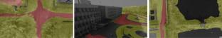
Recent years have witnessed a dramatic evolution in small-scale remote sensors such as Unmanned aerial vehicles (UAVs). Characteristics such as automatic flight control, flight time, and image acquisition have fueled various computer-vision tasks, providing better efficiency and usefulness than fixed viewing surveillance cameras. However, in constrained scenarios, the number of UAV-based aerial datasets is still low, which comparatively focuses on specific tasks such as image segmentation. In this paper, we present a high-resolution UAV-based image-dataset, named “NITRDrone” focusing on aerial image segmentation tasks especially extracting the road networks from the aerial images. The images and video sequences in this dataset are captured over different locations of the NITR campus area, covering around 650 acres. Thus, it provides many diversified scenarios to be considered while analyzing aerial images. In particular, the dataset is prepared to address the existing challenges in UAV-based aerial image segmentation problems. Extensive experiments have been conducted to prove the effectiveness of the proposed dataset to address the aerial segmentation problems through the existing state-of-the-art methodologies. Out of the considered baseline methodologies, U-Net performs the best with an intersection of union (IoU) of 0.77, followed DeepLabplusException (IoU: 0.74) and SegNet (IoU: 0.68). We hope the NITRDrone dataset will encourage the researchers while boosting the research and development in the visual analysis of UAV platforms. The NITRDrone dataset is available online at: [https://github.com/drone-vision/NITRDrone-Dataset].
中文翻译:
NITRDrone 数据集解决从航拍图像中提取道路的挑战
近年来,无人机(UAV)等小型遥感器发生了巨大的变化。自动飞行控制、飞行时间和图像采集等特性推动了各种计算机视觉任务,提供比固定观察监控摄像机更好的效率和实用性。然而,在受限场景中,基于无人机的航空数据集数量仍然很少,相对侧重于图像分割等特定任务。在本文中,我们提出了一个基于无人机的高分辨率图像数据集,名为“NITRDrone”,专注于航空图像分割任务,尤其是从航空图像中提取道路网络。该数据集中的图像和视频序列是在 NITR 校园区域的不同位置捕获的,占地约 650 英亩。因此,它提供了在分析航拍图像时需要考虑的许多多样化场景。特别是,该数据集准备解决基于无人机的航空图像分割问题中的现有挑战。已经进行了广泛的实验,以证明所提出的数据集通过现有的最先进的方法解决空中分割问题的有效性。在考虑的基线方法中,U-Net 表现最好,联合 (IoU) 的交集为 0.77,其次是 DeepLabplusException (IoU: 0.74) 和 SegNet (IoU: 0.68)。我们希望 NITRDrone 数据集能够鼓励研究人员,同时促进无人机平台视觉分析的研发。NITRDrone 数据集可在线获取:[https://github.com/drone-vision/NITRDrone-Dataset]。


 京公网安备 11010802027423号