Hydrogeology Journal ( IF 2.4 ) Pub Date : 2022-07-22 , DOI: 10.1007/s10040-022-02510-8 Igor Pavlovskii , Julia A. Cantelon , Barret L. Kurylyk
|
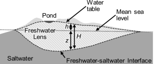
Coastal groundwater flow is driven by an interplay between terrestrial and marine forcings. One of the distinguishing features in these settings is the formation of a freshwater lens due to the density difference between fresh and saline groundwater. The present study uses data collected on Sable Island, Canada—a remote sand island in the northwest Atlantic Ocean—to highlight the potential of exploiting freshwater lens geometry for calibration of numerical groundwater flow models in coastal settings. Three numerical three-dimensional variable-density groundwater flow models were constructed for different segments of the island, with only one model calibrated using the freshwater–saltwater interface derived from an electromagnetic geophysical survey. The other two (uncalibrated) models with the same parameterisation as the calibrated model successfully reproduced the interpreted interface depth and location of freshwater ponds at different parts of the island. The successful numerical model calibration, based solely on the geophysically derived interface depth, is enabled by the interface acting as an amplified version of the water table, which reduces the relative impact of the interpreted depth uncertainty. Furthermore, the freshwater–saltwater interface is far more inertial than the water table, making it less sensitive to short-term forcings. Such “noise-filtering” behaviour enables the use of the freshwater–saltwater interface for calibration even in dynamic settings where selection of representative groundwater heads is challenging. The completed models provide insights into island freshwater lens behaviour and highlight the role of periodic beach inundation and wave overheight in driving short-term water-table variability, despite their limited impact on the interface depth.
中文翻译:
使用保留在淡水-咸水界面中的过滤和放大的水力信息进行沿海地下水模型校准
沿海地下水流是由陆地和海洋强迫之间的相互作用驱动的。这些环境中的显着特征之一是由于淡水和咸水地下水之间的密度差异而形成了淡水透镜体。本研究使用在加拿大西布尔岛(大西洋西北部的一个偏远沙岛)收集的数据来突出利用淡水透镜几何形状来校准沿海环境中数值地下水流模型的潜力。为岛屿的不同部分构建了三个数值三维可变密度地下水流模型,其中只有一个模型使用来自电磁地球物理调查的淡水-咸水界面进行校准。与校准模型具有相同参数化的另外两个(未校准)模型成功地再现了岛上不同部分淡水池塘的解释界面深度和位置。仅基于地球物理推导的界面深度的成功数值模型校准是通过界面作为地下水位的放大版本实现的,这减少了解释深度不确定性的相对影响。此外,淡水-咸水界面的惯性远大于地下水位,使其对短期强迫不敏感。这种“噪声过滤”行为使得即使在选择具有代表性的地下水头具有挑战性的动态环境中,也可以使用淡水-咸水界面进行校准。


 京公网安备 11010802027423号