Weather and Climate Extremes ( IF 6.1 ) Pub Date : 2022-07-20 , DOI: 10.1016/j.wace.2022.100482 Gert-Jan Duine , Leila M.V. Carvalho , Charles Jones
|
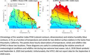
This study investigates mesoscale mechanisms associated with two extreme heatwaves affecting Santa Barbara County (SBC), southern California, and their implication for severe fire weather. We examine these issues using a database consisting of surface stations, radiosoundings, and 1 km grid spacing simulations with the Weather Research & Forecasting (WRF), including a climatology spanning 32 years. During the first heatwave event, synoptic conditions induced downslope winds on the southern-facing slopes of the Santa Ynez Mountains (SYM) on July 6, 2018. One surface station hit an all-time record, and nine surface stations exceeded 99.9th percentiles of surface temperatures. A wildfire (the Holiday Fire) erupted on the slopes of the SYM driven by high temperatures, low relative humidity, and strong winds. The nearby radiosonde registered temperatures at 850 hPa that exceeded the 95th percentile historical records (62 yrs). WRF simulations indicated that mountain wave activity contributed to the excessive surface temperatures on the south-facing slopes of the SYM, and explained the late evening timing for the maximum daily temperatures. The second heatwave broke all-time temperature records at 10 surface stations across SBC on September 6, 2020. Maximum temperatures for most of the SBC occurred during mid-afternoon, the highest observed temperature at the surface was 48.3 °C (118.9F), and the 850 hPa temperatures exceeded the 99th percentile. The September 2020 event occurred under weaker synoptic forcing (pressure gradients) than the July 2018 event, resulting in weaker winds in coastal Santa Barbara (including the slopes of the SYM) and Santa Ynez Valley. Nonetheless, the extreme heat and low relative humidity increased the Fosberg Fire Weather Index (FFWI) at critical values for a few hours in some sites when winds were moderate. To evaluate the relative importance of these extreme events in the historical context and to assess the region’s wildfire risk we propose a novel diagram based on the joint behavior of winds, temperature, humidity and FFWI. While no wildfires have broken out during the September 2020 heatwave, our analysis suggests that a combination of extreme heat with stronger winds would lead to unprecedented fire danger. These extreme conditions may become more common in a warming planet.
中文翻译:
与加利福尼亚州圣巴巴拉海岸的两个不同热浪事件相关的中尺度模式及其对当地火灾风险状况的影响
本研究调查了与影响南加州圣巴巴拉县 (SBC) 的两次极端热浪相关的中尺度机制及其对严重火灾天气的影响。我们使用由地面站、无线电探测和天气研究与预报 (WRF) 的 1 公里网格间隔模拟组成的数据库来检查这些问题,其中包括跨越 32 年的气候学。在第一次热浪事件期间,天气条件在 2018 年 7 月 6 日在圣伊内斯山脉 (SYM) 的南面斜坡上引发了下坡风。一个地面站创下了历史记录,九个地面站超过了 99.9%表面温度。在高温、低相对湿度和强风的驱动下,SYM 山坡上爆发了一场野火(假日火灾)。附近的无线电探空仪记录的温度为 850 hPa,超过了 95% 的历史记录(62 年)。WRF 模拟表明,山波活动导致 SYM 南向斜坡的表面温度过高,并解释了日最高温度的傍晚时间。2020 年 9 月 6 日,第二次热浪打破了 SBC 的 10 个地面站的历史温度记录。SBC 大部分地区的最高温度发生在下午中旬,地表观测到的最高温度为 48.3 °C(118.9 并解释了每日最高气温的深夜时间。2020 年 9 月 6 日,第二次热浪打破了 SBC 的 10 个地面站的历史温度记录。SBC 大部分地区的最高温度发生在下午中旬,地表观测到的最高温度为 48.3 °C(118.9 并解释了每日最高气温的深夜时间。2020 年 9 月 6 日,第二次热浪打破了 SBC 的 10 个地面站的历史温度记录。SBC 大部分地区的最高温度发生在下午中旬,地表观测到的最高温度为 48.3 °C(118.9F), 850 hPa 温度超过第 99 个百分位。2020 年 9 月的事件发生在比 2018 年 7 月事件更弱的天气强迫(压力梯度)下,导致圣巴巴拉海岸(包括 SYM 斜坡)和圣伊内斯山谷的风更弱。尽管如此,极端高温和低相对湿度在一些风速适中的地点将福斯贝格火灾天气指数 (FFWI) 提高了几个小时的临界值。为了评估这些极端事件在历史背景下的相对重要性并评估该地区的野火风险,我们提出了一个基于风、温度、湿度和 FFWI 联合行为的新图表。虽然在 2020 年 9 月的热浪期间没有发生野火,但 我们的分析表明,极端高温与强风相结合将导致前所未有的火灾危险。这些极端条件在地球变暖中可能会变得更加普遍。


 京公网安备 11010802027423号