当前位置:
X-MOL 学术
›
Remote Sens. Ecol. Conserv.
›
论文详情
Our official English website, www.x-mol.net, welcomes your
feedback! (Note: you will need to create a separate account there.)
Tracking canopy gaps in mangroves remotely using deep learning
Remote Sensing in Ecology and Conservation ( IF 3.9 ) Pub Date : 2022-07-12 , DOI: 10.1002/rse2.289 Guillaume Lassalle 1 , Carlos Roberto de Souza Filho 1
Remote Sensing in Ecology and Conservation ( IF 3.9 ) Pub Date : 2022-07-12 , DOI: 10.1002/rse2.289 Guillaume Lassalle 1 , Carlos Roberto de Souza Filho 1
Affiliation
|
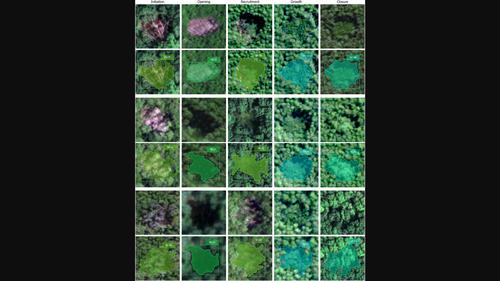
Mangroves are among the most ecologically valuable ecosystems of the globe. Reliable remote sensing solutions are required to assist their management and conservation at broad scale. Canopy gaps are part of forests' turnover and rejuvenation, but yet no method has been proposed to map their occurrence and recovery in mangroves. Here, were propose an approach based on a deep learning framework called Mask R-CNN to achieve automatic detection and delineation of gaps using very-high-resolution satellite imagery (<1 m). The Mask R-CNN combines a series of neural network architectures to identify and delineate gaps, determine their recovery stage, and estimate their morphological attributes. The approach was tested on four mangroves from different regions of the globe with high concentration of gaps of various origins (lightning strikes, oil spills, cutting, pests). The Mask R-CNN performed well to detect gaps, and accurately delineated gap contours (F1-score of segmentation ≥0.89). The model also succeeded in distinguishing among five recovery stages of gaps, from their onset to closure (Overall Accuracy = 91.4, Kappa = 0.89). Accurate retrieval of gap area, eccentricity, and compactness – three relevant morphological attributes – were obtained (R2 ≥ 0.83, NRMSE ≤10%). Several sources of confusion and misdelineation were identified. Our approach shows promising transferability to other mangrove sites and optical sensors and could help monitor canopy recovery in mangroves. It also opens promising perspectives for identifying the origin of gaps (natural or human-induced). It is intended to assist environmental managers and field experts in the management and conservation of these fragile ecosystems.
中文翻译:

使用深度学习远程跟踪红树林中的树冠间隙
红树林是全球最具生态价值的生态系统之一。需要可靠的遥感解决方案来协助大规模管理和保护它们。冠层缺口是森林周转和恢复的一部分,但尚未提出任何方法来绘制它们在红树林中的发生和恢复。在这里,我们提出了一种基于称为 Mask R-CNN 的深度学习框架的方法,以使用超高分辨率卫星图像(<1 m)实现自动检测和描绘间隙。Mask R-CNN 结合了一系列神经网络架构来识别和描绘间隙,确定它们的恢复阶段,并估计它们的形态属性。该方法在全球不同地区的四棵红树林上进行了测试,这些红树林具有高度集中的各种来源的间隙(雷击,漏油、切割、害虫)。Mask R-CNN 在检测间隙方面表现良好,并准确描绘了间隙轮廓(分割的 F1 分数≥0.89)。该模型还成功区分了差距的五个恢复阶段,从开始到结束(总体准确度 = 91.4,Kappa = 0.89)。准确检索间隙面积、偏心率和紧密度——三个相关的形态学属性——获得了(R 2 ≥ 0.83,NRMSE ≤10%)。确定了几个混淆和错误描述的来源。我们的方法显示出对其他红树林地点和光学传感器的可移植性很有希望,并且可以帮助监测红树林的树冠恢复情况。它还为识别差距的起源(自然或人为引起)开辟了有前途的前景。它旨在帮助环境管理者和现场专家管理和保护这些脆弱的生态系统。
更新日期:2022-07-12
中文翻译:
使用深度学习远程跟踪红树林中的树冠间隙
红树林是全球最具生态价值的生态系统之一。需要可靠的遥感解决方案来协助大规模管理和保护它们。冠层缺口是森林周转和恢复的一部分,但尚未提出任何方法来绘制它们在红树林中的发生和恢复。在这里,我们提出了一种基于称为 Mask R-CNN 的深度学习框架的方法,以使用超高分辨率卫星图像(<1 m)实现自动检测和描绘间隙。Mask R-CNN 结合了一系列神经网络架构来识别和描绘间隙,确定它们的恢复阶段,并估计它们的形态属性。该方法在全球不同地区的四棵红树林上进行了测试,这些红树林具有高度集中的各种来源的间隙(雷击,漏油、切割、害虫)。Mask R-CNN 在检测间隙方面表现良好,并准确描绘了间隙轮廓(分割的 F1 分数≥0.89)。该模型还成功区分了差距的五个恢复阶段,从开始到结束(总体准确度 = 91.4,Kappa = 0.89)。准确检索间隙面积、偏心率和紧密度——三个相关的形态学属性——获得了(R 2 ≥ 0.83,NRMSE ≤10%)。确定了几个混淆和错误描述的来源。我们的方法显示出对其他红树林地点和光学传感器的可移植性很有希望,并且可以帮助监测红树林的树冠恢复情况。它还为识别差距的起源(自然或人为引起)开辟了有前途的前景。它旨在帮助环境管理者和现场专家管理和保护这些脆弱的生态系统。


 京公网安备 11010802027423号