International Journal of Applied Earth Observation and Geoinformation ( IF 7.6 ) Pub Date : 2022-07-12 , DOI: 10.1016/j.jag.2022.102897 Sensen Wu , Jin Qi , Zhen Yan , Fangzheng Lyu , Tao Lin , Yuanyuan Wang , Zhenhong Du
|
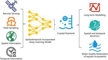
Revealing the spatiotemporal variations of nutrients in coastal waters is crucial to the understanding and evaluation of coastal environment, thereby providing efficient guidance for the aquatic environmental treatment. This study proposed a spatiotemporal-incorporated deep learning model, which is easily applicable to establish the quantitative relationships between measured environmental factors and large-scale satellite maps, and can reduce estimation errors by more than 40% compared with non-spatiotemporal-incorporated deep learning model. The spatiotemporal distributions of dissolved inorganic nitrogen (DIN) and dissolved inorganic phosphate (DIP) over 44400 km2 of the East China Sea on 8-day scale from 2010 to 2018 were obtained. Based on the spatiotemporal variations, the water quality patterns were depicted, and the fluctuation variations of the two essential nutrients were found in the harbors with complex anthropogenic influences, in the typical estuaries with multiple river inputs, and in the open seas with important fisheries. Although the concentration of DIN and DIP decreased by 24% and 19% in 9 years, respectively, the water quality level in the inshore sea has not been significantly improved, especially in autumn and winter. Further, we quantitatively analyzed the main factors of deteriorated water and provided scientific suggestions for targeted monitoring and regional cooperative governances.
中文翻译:
利用遥感和时空深度学习模型对沿海地区养分和水质进行时空评估
揭示近岸水域营养物质的时空变化对于了解和评价近岸环境至关重要,从而为水环境治理提供有效指导。本研究提出了一种时空结合深度学习模型,该模型易于用于建立测量环境因素与大尺度卫星地图之间的定量关系,与非时空结合深度学习相比,可以将估计误差降低40%以上模型。44400 km 2范围内溶解无机氮(DIN)和溶解无机磷酸盐(DIP)的时空分布获得了 2010 年至 2018 年 8 天尺度的东海海况。在时空变化的基础上,描绘了水质模式,并在人为影响复杂的港口、多条河流输入的典型河口和重要渔业的公海发现了两种必需营养素的波动变化。虽然 DIN 和 DIP 的浓度在 9 年内分别下降了 24% 和 19%,但近岸海域的水质水平并没有明显改善,尤其是在秋冬季。进一步定量分析了水质恶化的主要因素,为精准监测和区域合作治理提供了科学建议。


 京公网安备 11010802027423号