Bulletin of Engineering Geology and the Environment ( IF 3.7 ) Pub Date : 2022-07-11 , DOI: 10.1007/s10064-022-02806-9 Kumari Sweta , Ajanta Goswami , Bipin Peethambaran , I. M. Bahuguna , A. S. Rajawat
|
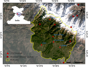
Landslide susceptibility zonation (LSZ) is a prerequisite for sustainable development and disaster management, especially in mountainous settings. In recent landslide literature, due to the shortcomings of qualitative, statistical, and probabilistic approaches, artificial intelligence (AI) techniques are widely applied for geographic information system–based LSZ. Dharamshala, state capital of Himachal, is one of India’s fastest-growing tourist hotspots in Himalaya where developmental activities are taking place at a rapid pace. Increased pressure of urbanization and re-occurrence of slope instability problems demand systemic landslide hazard evaluation in this area. In this respect, GIS-based LSZ has been attempted for this area using different AI models: fuzzy set procedure (FSP), the fuzzy expert system (FES), and artificial neural network (ANN). To create the landslide susceptibility map (LSM), 9 causative factors and landslide inventory were defined using remote sensing and field data. A total of 12 LSMs were generated, then validated and compared statistically with the help of area under the receiver operating characteristic (ROC) curve and frequency ratio (FR) analysis, and also in terms of spatial distribution quality to depict an accurate map for the study area. The comparative analysis shows that ANN performs better than the other two models, and LSM-ANN-I is the best map for the research area. The northern section, made of metamorphic rocks like slate and phyllite, with a high slope, is more prone to landslides, whereas the southern part, comprised sandstone, shale, on gentle slopes, has minimal landslide susceptibility.
中文翻译:
印度喜马偕尔邦达兰萨拉周边滑坡敏感性分区:基于人工智能模型的评估
滑坡敏感性区划 (LSZ) 是可持续发展和灾害管理的先决条件,尤其是在山区环境中。在最近的滑坡文献中,由于定性、统计和概率方法的缺点,人工智能(AI)技术被广泛应用于基于地理信息系统的 LSZ。喜马偕尔邦首府达兰萨拉是印度喜马拉雅地区发展最快的旅游热点之一,这里的发展活动正在迅速开展。城市化压力的增加和边坡失稳问题的再次发生需要对该地区进行系统的滑坡灾害评估。在这方面,基于 GIS 的 LSZ 已尝试使用不同的 AI 模型在该领域进行:模糊集过程 (FSP)、模糊专家系统 (FES) 和人工神经网络 (ANN)。为了创建滑坡敏感性图 (LSM),使用遥感和现场数据定义了 9 个成因和滑坡清单。总共生成了 12 个 LSM,然后在接受者操作特征 (ROC) 曲线下面积和频率比 (FR) 分析的帮助下进行了验证和统计比较,并在空间分布质量方面描绘了准确的地图研究区。对比分析表明,ANN 的表现优于其他两种模型,LSM-ANN-I 是研究领域的最佳映射。北部由板岩和千枚岩等变质岩组成,坡度高,更容易发生滑坡,而南部由砂岩、页岩组成,坡度平缓,滑坡敏感性最小。使用遥感和现场数据确定了 9 个成因和滑坡清单。总共生成了 12 个 LSM,然后在接受者操作特征 (ROC) 曲线下面积和频率比 (FR) 分析的帮助下进行了验证和统计比较,并在空间分布质量方面描绘了准确的地图研究区。对比分析表明,ANN 的表现优于其他两种模型,LSM-ANN-I 是研究领域的最佳映射。北部由板岩和千枚岩等变质岩组成,坡度高,更容易发生滑坡,而南部由砂岩、页岩组成,坡度平缓,滑坡敏感性最小。使用遥感和现场数据确定了 9 个成因和滑坡清单。总共生成了 12 个 LSM,然后在接受者操作特征 (ROC) 曲线下面积和频率比 (FR) 分析的帮助下进行了验证和统计比较,并在空间分布质量方面描绘了准确的地图研究区。对比分析表明,ANN 的表现优于其他两种模型,LSM-ANN-I 是研究领域的最佳映射。北部由板岩和千枚岩等变质岩组成,坡度高,更容易发生滑坡,而南部由砂岩、页岩组成,坡度平缓,滑坡敏感性最小。总共生成了 12 个 LSM,然后在接受者操作特征 (ROC) 曲线下面积和频率比 (FR) 分析的帮助下进行了验证和统计比较,并在空间分布质量方面描绘了准确的地图研究区。对比分析表明,ANN 的表现优于其他两种模型,LSM-ANN-I 是研究领域的最佳映射。北部由板岩和千枚岩等变质岩组成,坡度高,更容易发生滑坡,而南部由砂岩、页岩组成,坡度平缓,滑坡敏感性最小。总共生成了 12 个 LSM,然后在接受者操作特征 (ROC) 曲线下面积和频率比 (FR) 分析的帮助下进行了验证和统计比较,并在空间分布质量方面描绘了准确的地图研究区。对比分析表明,ANN 的表现优于其他两种模型,LSM-ANN-I 是研究领域的最佳映射。北部由板岩和千枚岩等变质岩组成,坡度高,更容易发生滑坡,而南部由砂岩、页岩组成,坡度平缓,滑坡敏感性最小。以及在空间分布质量方面为研究区域描绘准确的地图。对比分析表明,ANN 的表现优于其他两种模型,LSM-ANN-I 是研究领域的最佳映射。北部由板岩和千枚岩等变质岩组成,坡度高,更容易发生滑坡,而南部由砂岩、页岩组成,坡度平缓,滑坡敏感性最小。以及在空间分布质量方面为研究区域描绘准确的地图。对比分析表明,ANN 的表现优于其他两种模型,LSM-ANN-I 是研究领域的最佳映射。北部由板岩和千枚岩等变质岩组成,坡度高,更容易发生滑坡,而南部由砂岩、页岩组成,坡度平缓,滑坡敏感性最小。


 京公网安备 11010802027423号