Lithology and Mineral Resources ( IF 0.7 ) Pub Date : 2022-07-02 , DOI: 10.1134/s0024490222040071 N. V. Sychev , E. A. Konstantinov , A. L. Zakharov , M. Frechen , S. Tsukamoto
|
Abstract
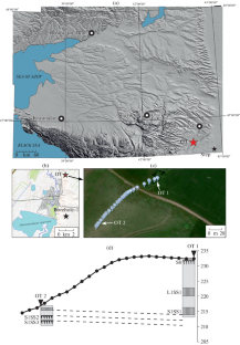
Drilling recovered the upper part (23 m) of the upland loess–paleosol series (LPS) on the right bank of the Kuma River near the Otkaznoe Settlement. Description of cores and laboratory analyses made it possible to carry out lithostratigraphic subdivision of the loess sequence in the summary column. Four paleosol units separated by loess horizons are identified. The two lower contiguous paleosols are defined well in the cores by their dark brown color and high values of magnetic susceptibility. The other two paleosols are weakly expressed and identified mainly by variations in the mechanical composition and contents of organic matter and carbonates. Analysis of 13 luminescence dates obtained in two different laboratories (four dates at Karpinsky Russian Research Geological Institute (VSEGEI), St. Petersburg, Russia; nine dates at Leibniz Institute for Applied Geophysics (LIAG), Hannover, Germany) shows that the LPS belongs to the Late Pleistocene and Holocene. Based on the dates, three (two Bayesian and one linear) depth-age models were constructed. The linear model is in better agreement with the stratigraphic sequence and the cross-regional loess correlation. The age of boundaries of the stratigraphic units was calculated, and a preliminary correlation with the marine oxygen isotope stages (MIS) was carried out: soil S0—MIS 1; loess L1LL1—MIS 2; paleosol L1SS1—MIS 3; loess L1LL2—MIS 4; paleosol S1SS1—MIS 5a; loess S1LL1—MIS 5b; paleosol S1SS2—MIS 5c; loess S1LL2—MIS 5d; and paleosol S1SS3—MIS 5e. Calculations of the sedimentation rate yielded the following results: minimum growth rate of the loess sequence in the Holocene (9 cm/ka) and Mikulino time (10 cm/ka); maximum rate, at the end of the middle–beginning of the late Valdaian (79 cm/ka). Pedostratigraphy and compositional variations give grounds for correlating the summary column with the core of reference Borehole-1 drilled in the Otkaznoe Settlement in 1986.
中文翻译:
Terek-Kuma 低地上第四纪黄土-土壤系列年代学新数据
摘要
钻探在 Otkaznoe 聚落附近的 Kuma 河右岸恢复了高地黄土 - 古土壤系列 (LPS) 的上部 (23 m)。岩心和实验室分析的描述使得在总结栏中对黄土序列进行岩石地层细分成为可能。确定了由黄土层隔开的四个古土壤单元。两个较低的连续古土壤在岩心中由它们的深棕色和高磁化率值很好地定义。其他两种古土壤的表现较弱,主要通过有机质和碳酸盐的机械成分和含量的变化来识别和识别。分析在两个不同实验室获得的 13 个发光日期(四个日期在俄罗斯圣彼得堡的 Karpinsky 俄罗斯地质研究所 (VSEGEI);德国汉诺威莱布尼茨应用地球物理研究所 (LIAG) 的 9 个日期表明 LPS 属于晚更新世和全新世。根据这些日期,构建了三个(两个贝叶斯和一个线性)深度年龄模型。线性模型与地层序列和跨区域黄土相关性吻合较好。计算了地层单元的边界年龄,并与海洋氧同位素阶段(MIS)进行了初步对比:土壤S0—MIS 1;黄土 L1LL1—MIS 2;古土壤 L1SS1—MIS 3;黄土 L1LL2—MIS 4;古土壤 S1SS1—MIS 5a;黄土 S1LL1—MIS 5b;古土壤 S1SS2—MIS 5c;黄土 S1LL2—MIS 5d;和古土壤 S1SS3—MIS 5e。沉降速率的计算得出以下结果:全新世(9 cm/ka)和 Mikulino 时期(10 cm/ka)黄土层序的最小生长速率;最大速率,在瓦尔代晚期中前期末期(79 cm/ka)。地层学和成分变化为将汇总柱与 1986 年在 Otkaznoe 定居点钻探的参考 Borehole-1 核心相关联提供了依据。


 京公网安备 11010802027423号