Hydrogeology Journal ( IF 2.4 ) Pub Date : 2022-06-23 , DOI: 10.1007/s10040-022-02506-4 Radegonde Rusagara , Mahamadou Koïta , Valérie Plagnes , Anne Jost
|
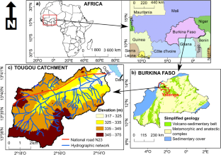
Groundwater recharge rate for weathered rock aquifers in the Sahel of West Africa is sparse due to insufficient knowledge of the recharge pathways. This study was initiated in the Tougou ephemeral river catchment (37 km2) to improve understanding of recharge pathways to a weathered rock aquifer in the dryland of Burkina Faso. It is based on field investigations conducted in 2016–2020 on a piezometric transect and large-diameter wells, perpendicular and longitudinal to the river, respectively. Geophysical measurements, lithologs analysis, permeability tests, groundwater and river level monitoring, and rainfall measurements were undertaken. The results showed a laterally continuous saprolite aquifer (10–22 m thick) overlain by residual soils beneath the river and discontinuous laterite on the banks. Below the river, the saprolite overlays the weathered schist aquifer with an upward or downward hydraulic gradient regardless of the seasons. The saprolite is replenished by focused recharge from the river and diffuse recharge from the rainfall on the banks, according to information from the groundwater hydrographs, groundwater tracing results, and cross-correlation between the groundwater levels and the two potential recharge sources (rainfall and river water). The low hydraulic conductivity, electrical resistivity tomography profiles and lithologs indicate restriction of diffuse and focused recharge through soil matrix infiltration, suggesting there are preferential recharge pathways. For the 2018–2020 period, the water-table fluctuation method provides recharge estimates of 14–51 mm/year on the northern bank, 10–36 mm/year on the southern bank and 148–194 mm/year in the riverbed.
中文翻译:
布基纳法索旱地集水区风化岩含水层系统的地下水补给路径
由于对补给途径的了解不足,西非萨赫勒地区风化岩石含水层的地下水补给率稀少。本研究在头沟临时河流流域(37 km 2) 以提高对布基纳法索旱地风化岩石含水层补给途径的了解。它基于 2016-2020 年对分别垂直和纵向河流的测压样带和大直径井进行的现场调查。进行了地球物理测量、岩性分析、渗透率测试、地下水和河流水位监测以及降雨测量。结果显示横向连续的腐泥土含水层(10-22 m 厚)被河流下方的残留土壤和河岸上不连续的红土覆盖。在河流下方,腐泥土以向上或向下的水力梯度覆盖风化的片岩含水层,无论季节如何。腐泥土通过来自河流的集中补给和来自河岸降雨的扩散补给来补充,根据来自地下水水位线的信息、地下水追踪结果,以及地下水位与两个潜在补给源(降雨和河水)之间的互相关性。低水力传导率、电阻率断层扫描剖面和岩性表明通过土壤基质入渗限制了扩散和集中补给,表明存在优先补给途径。对于 2018-2020 年,地下水位波动方法提供的补给估计为北岸 14-51 毫米/年,南岸 10-36 毫米/年,河床 148-194 毫米/年。低水力传导率、电阻率断层扫描剖面和岩性表明通过土壤基质入渗限制了扩散和集中补给,表明存在优先补给途径。对于 2018-2020 年,地下水位波动方法提供的补给估计为北岸 14-51 毫米/年,南岸 10-36 毫米/年,河床 148-194 毫米/年。低水力传导率、电阻率断层扫描剖面和岩性表明通过土壤基质入渗限制了扩散和集中补给,表明存在优先补给途径。对于 2018-2020 年,地下水位波动方法提供的补给估计为北岸 14-51 毫米/年,南岸 10-36 毫米/年,河床 148-194 毫米/年。


 京公网安备 11010802027423号