Remote Sensing of Environment ( IF 11.1 ) Pub Date : 2022-06-17 , DOI: 10.1016/j.rse.2022.113112 Vítězslav Moudrý , Kateřina Gdulová , Lukáš Gábor , Eliška Šárovcová , Vojtěch Barták , Francois Leroy , Olga Špatenková , Duccio Rocchini , Jiří Prošek
|
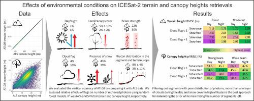
The ICESat-2 ATL08 land and vegetation product includes several flags that can be used for the assessment of LiDAR-environment interactions and can help select data of the highest quality. However, the usability of these flags has not been sufficiently studied to date. Here, we aimed to evaluate the effects of atmospheric scattering, the presence of snow, canopy cover, terrain slope, beam strength, and solar angle on the accuracy of terrain and canopy height of the ATL08 product as well as on providing recommendations on how to filter data in order to minimize errors. We evaluated the vertical accuracy of ATL08 terrain and canopy height in European mountains by comparing them with the digital terrain model and canopy height model derived from airborne laser scanning data. Our results indicate that the assessment of atmospheric effects using the cloud confidence flag (cloud_flag_atm; i.e. number of cloud layers) is better than the previously used multiple scattering warning flag (msw_flag). Day acquisitions with more than one layer of clouds yielded a terrain elevation RMSE of 3.22 m in forests while night acquisitions with no more than a single layer of clouds resulted in RMSE of 1.73 m. The increasing atmospheric scattering effects increased the photons' path length, resulting in terrain height underestimation. The presence of snow had a strong positive effect on the number of identified ground photons, independently of the canopy cover, but resulted in an overestimation of terrain height in higher altitudes. Accordingly, the presence of snow cover resulted in a significant underestimation of canopy height in forests. The canopy height in broadleaf/mixed as well as coniferous forests was in summer underestimated on average by 2.1 m (%ME of −15.3%) and 1.2 m (%ME of −8.2%), respectively; in winter, however, the underestimation increased to 8.5 m (%ME of −56.8%) and 5.7 m (%ME of −38.3%), respectively. Canopy height estimates had better accuracy for the strong beam (RMSE of 5.09 m; %RMSE of 35.4%) than for the weak beam (RMSE of 7.03 m; %RMSE of 51.3%). Our results show that the ATL08 terrain height accuracy decreases with uneven distribution of signal photons within individual segments and further deteriorates with increasing terrain slope. Filtering out segments with poor distribution of photons, more than one layer of clouds during the day, and snow cover in high altitudes is the best approach for minimizing the error while maximizing the number of segments left for subsequent analysis.
中文翻译:
环境条件对中欧山区ICESat-2地形和冠层高度反演的影响
ICESat-2 ATL08 土地和植被产品包括几个标志,可用于评估 LiDAR 与环境的相互作用,并有助于选择最高质量的数据。然而,迄今为止,这些标志的可用性尚未得到充分研究。在这里,我们旨在评估大气散射、雪的存在、树冠覆盖、地形坡度、光束强度和太阳角度对 ATL08 产品的地形精度和树冠高度的影响,并就如何提供建议过滤数据以减少错误。我们通过与机载激光扫描数据导出的数字地形模型和冠层高度模型进行比较,评估了欧洲山区 ATL08 地形和冠层高度的垂直精度。cloud_flag_atm ; 即云层数)优于之前使用的多次散射警告标志(msw_flag)。多于一层云的白天采集在森林中产生 3.22 m 的地形海拔 RMSE,而在不超过一层云的夜间采集导致 RMSE 为 1.73 m。增加的大气散射效应增加了光子的路径长度,导致地形高度被低估。雪的存在对已识别的地面光子数量有很强的积极影响,与树冠覆盖无关,但会导致高海拔地区的地形高度被高估。因此,积雪的存在导致森林冠层高度被严重低估。夏季,阔叶林/混交林和针叶林的冠层高度分别被低估了 2.1 m(%ME 为 -15.3%)和 1.2 m(%ME 为 -8.2%);然而在冬天,低估分别增加到 8.5 m(%ME 为 -56.8%)和 5.7 m(%ME 为 -38.3%)。强光束(RMSE 为 5.09 m;%RMSE 为 35.4%)的冠层高度估计比弱光束(RMSE 为 7.03 m;%RMSE 为 51.3%)具有更好的准确度。我们的结果表明,ATL08 地形高度精度随着单个段内信号光子的不均匀分布而降低,并随着地形坡度的增加而进一步恶化。滤除光子分布不佳、白天多于一层云层以及高海拔地区积雪的片段是最大程度地减少误差的最佳方法,同时最大程度地增加用于后续分析的片段数量。%RMSE 为 35.4%)比弱光束(RMSE 为 7.03 m;%RMSE 为 51.3%)。我们的结果表明,ATL08 地形高度精度随着单个段内信号光子的不均匀分布而降低,并随着地形坡度的增加而进一步恶化。滤除光子分布不佳、白天多于一层云层以及高海拔地区积雪的片段是最大程度地减少误差的最佳方法,同时最大程度地增加用于后续分析的片段数量。%RMSE 为 35.4%)比弱光束(RMSE 为 7.03 m;%RMSE 为 51.3%)。我们的结果表明,ATL08 地形高度精度随着单个段内信号光子的不均匀分布而降低,并随着地形坡度的增加而进一步恶化。过滤掉光子分布不佳、白天多于一层云层以及高海拔地区积雪的片段是最小化误差同时最大化剩余用于后续分析的片段数量的最佳方法。


 京公网安备 11010802027423号