当前位置:
X-MOL 学术
›
Remote Sens. Ecol. Conserv.
›
论文详情
Our official English website, www.x-mol.net, welcomes your
feedback! (Note: you will need to create a separate account there.)
Deep learning detects invasive plant species across complex landscapes using Worldview-2 and Planetscope satellite imagery
Remote Sensing in Ecology and Conservation ( IF 3.9 ) Pub Date : 2022-06-13 , DOI: 10.1002/rse2.288 Thomas A. Lake 1 , Ryan D. Briscoe Runquist 1 , David A. Moeller 1
Remote Sensing in Ecology and Conservation ( IF 3.9 ) Pub Date : 2022-06-13 , DOI: 10.1002/rse2.288 Thomas A. Lake 1 , Ryan D. Briscoe Runquist 1 , David A. Moeller 1
Affiliation
|
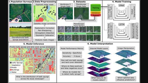
Effective management of invasive species requires rapid detection and dynamic monitoring. Remote sensing offers an efficient alternative to field surveys for invasive plants; however, distinguishing individual plant species can be challenging especially over geographic scales. Satellite imagery is the most practical source of data for developing predictive models over landscapes, but spatial resolution and spectral information can be limiting. We used two types of satellite imagery to detect the invasive plant, leafy spurge (Euphorbia virgata), across a heterogeneous landscape in Minnesota, USA. We developed convolutional neural networks (CNNs) with imagery from Worldview-2 and Planetscope satellites. Worldview-2 imagery has high spatial and spectral resolution, but images are not routinely taken in space or time. By contrast, Planetscope imagery has lower spatial and spectral resolution, but images are taken daily across Earth. The former had 96.1% accuracy in detecting leafy spurge, whereas the latter had 89.9% accuracy. Second, we modified the CNN for Planetscope with a long short-term memory (LSTM) layer that leverages information on phenology from a time series of images. The detection accuracy of the Planetscope LSTM model was 96.3%, on par with the high resolution, Worldview-2 model. Across models, most false-positive errors occurred near true populations, indicating that these errors are not consequential for management. We identified that early and mid-season phenological periods in the Planetscope time series were key to predicting leafy spurge. Additionally, green, red-edge and near-infrared spectral bands were important for differentiating leafy spurge from other vegetation. These findings suggest that deep learning models can accurately identify individual species over complex landscapes even with satellite imagery of modest spatial and spectral resolution if a temporal series of images is incorporated. Our results will help inform future management efforts using remote sensing to identify invasive plants, especially across large-scale, remote and data-sparse areas.
中文翻译:

深度学习使用 Worldview-2 和 Planetscope 卫星图像检测复杂景观中的入侵植物物种
入侵物种的有效管理需要快速检测和动态监测。遥感为入侵植物实地调查提供了一种有效的替代方法;然而,区分单个植物物种可能具有挑战性,尤其是在地理范围内。卫星图像是开发景观预测模型最实用的数据来源,但空间分辨率和光谱信息可能会受到限制。我们使用两种类型的卫星图像来检测入侵植物,多叶大戟(Euphorbia virgata),横跨美国明尼苏达州的异质景观。我们利用 Worldview-2 和 Planetscope 卫星的图像开发了卷积神经网络 (CNN)。Worldview-2 图像具有高空间和光谱分辨率,但通常不会在空间或时间上拍摄图像。相比之下,Planetscope 图像的空间和光谱分辨率较低,但每天都会在地球上拍摄图像。前者在检测叶状大戟方面的准确率为 96.1%,而后者的准确率为 89.9%。其次,我们使用长短期记忆 (LSTM) 层修改了 Planetscope 的 CNN,该层利用了时间序列图像中的物候信息。Planetscope LSTM 模型的检测精度为 96.3%,与高分辨率 Worldview-2 模型相当。在所有模型中,大多数假阳性错误发生在真实人群附近,表明这些错误对管理没有影响。我们发现,Planetscope 时间序列中的早期和中期物候期是预测多叶大戟的关键。此外,绿色、红色边缘和近红外光谱带对于区分多叶大戟与其他植物很重要。这些发现表明,如果结合了时间序列图像,即使使用适度空间和光谱分辨率的卫星图像,深度学习模型也可以准确识别复杂景观中的单个物种。我们的结果将有助于为未来的管理工作提供信息,使用遥感来识别入侵植物,尤其是在大规模、偏远和数据稀疏的地区。我们发现,Planetscope 时间序列中的早期和中期物候期是预测多叶大戟的关键。此外,绿色、红色边缘和近红外光谱带对于区分多叶大戟与其他植物很重要。这些发现表明,如果结合了时间序列图像,即使使用适度空间和光谱分辨率的卫星图像,深度学习模型也可以准确识别复杂景观中的单个物种。我们的结果将有助于为未来的管理工作提供信息,使用遥感来识别入侵植物,尤其是在大规模、偏远和数据稀疏的地区。我们发现,Planetscope 时间序列中的早期和中期物候期是预测多叶大戟的关键。此外,绿色、红色边缘和近红外光谱带对于区分多叶大戟与其他植物很重要。这些发现表明,如果结合了时间序列图像,即使使用适度空间和光谱分辨率的卫星图像,深度学习模型也可以准确识别复杂景观中的单个物种。我们的结果将有助于为未来的管理工作提供信息,使用遥感来识别入侵植物,尤其是在大规模、偏远和数据稀疏的地区。这些发现表明,如果结合了时间序列图像,即使使用适度空间和光谱分辨率的卫星图像,深度学习模型也可以准确识别复杂景观中的单个物种。我们的结果将有助于为未来的管理工作提供信息,使用遥感来识别入侵植物,尤其是在大规模、偏远和数据稀疏的地区。这些发现表明,如果结合了时间序列图像,即使使用适度空间和光谱分辨率的卫星图像,深度学习模型也可以准确识别复杂景观中的单个物种。我们的结果将有助于为未来的管理工作提供信息,使用遥感来识别入侵植物,尤其是在大规模、偏远和数据稀疏的地区。
更新日期:2022-06-13
中文翻译:
深度学习使用 Worldview-2 和 Planetscope 卫星图像检测复杂景观中的入侵植物物种
入侵物种的有效管理需要快速检测和动态监测。遥感为入侵植物实地调查提供了一种有效的替代方法;然而,区分单个植物物种可能具有挑战性,尤其是在地理范围内。卫星图像是开发景观预测模型最实用的数据来源,但空间分辨率和光谱信息可能会受到限制。我们使用两种类型的卫星图像来检测入侵植物,多叶大戟(Euphorbia virgata),横跨美国明尼苏达州的异质景观。我们利用 Worldview-2 和 Planetscope 卫星的图像开发了卷积神经网络 (CNN)。Worldview-2 图像具有高空间和光谱分辨率,但通常不会在空间或时间上拍摄图像。相比之下,Planetscope 图像的空间和光谱分辨率较低,但每天都会在地球上拍摄图像。前者在检测叶状大戟方面的准确率为 96.1%,而后者的准确率为 89.9%。其次,我们使用长短期记忆 (LSTM) 层修改了 Planetscope 的 CNN,该层利用了时间序列图像中的物候信息。Planetscope LSTM 模型的检测精度为 96.3%,与高分辨率 Worldview-2 模型相当。在所有模型中,大多数假阳性错误发生在真实人群附近,表明这些错误对管理没有影响。我们发现,Planetscope 时间序列中的早期和中期物候期是预测多叶大戟的关键。此外,绿色、红色边缘和近红外光谱带对于区分多叶大戟与其他植物很重要。这些发现表明,如果结合了时间序列图像,即使使用适度空间和光谱分辨率的卫星图像,深度学习模型也可以准确识别复杂景观中的单个物种。我们的结果将有助于为未来的管理工作提供信息,使用遥感来识别入侵植物,尤其是在大规模、偏远和数据稀疏的地区。我们发现,Planetscope 时间序列中的早期和中期物候期是预测多叶大戟的关键。此外,绿色、红色边缘和近红外光谱带对于区分多叶大戟与其他植物很重要。这些发现表明,如果结合了时间序列图像,即使使用适度空间和光谱分辨率的卫星图像,深度学习模型也可以准确识别复杂景观中的单个物种。我们的结果将有助于为未来的管理工作提供信息,使用遥感来识别入侵植物,尤其是在大规模、偏远和数据稀疏的地区。我们发现,Planetscope 时间序列中的早期和中期物候期是预测多叶大戟的关键。此外,绿色、红色边缘和近红外光谱带对于区分多叶大戟与其他植物很重要。这些发现表明,如果结合了时间序列图像,即使使用适度空间和光谱分辨率的卫星图像,深度学习模型也可以准确识别复杂景观中的单个物种。我们的结果将有助于为未来的管理工作提供信息,使用遥感来识别入侵植物,尤其是在大规模、偏远和数据稀疏的地区。这些发现表明,如果结合了时间序列图像,即使使用适度空间和光谱分辨率的卫星图像,深度学习模型也可以准确识别复杂景观中的单个物种。我们的结果将有助于为未来的管理工作提供信息,使用遥感来识别入侵植物,尤其是在大规模、偏远和数据稀疏的地区。这些发现表明,如果结合了时间序列图像,即使使用适度空间和光谱分辨率的卫星图像,深度学习模型也可以准确识别复杂景观中的单个物种。我们的结果将有助于为未来的管理工作提供信息,使用遥感来识别入侵植物,尤其是在大规模、偏远和数据稀疏的地区。


 京公网安备 11010802027423号