Journal of Geodesy ( IF 3.9 ) Pub Date : 2022-06-10 , DOI: 10.1007/s00190-022-01626-9 Sara Bruni , Luciana Fenoglio , Fabio Raicich , Susanna Zerbini
|
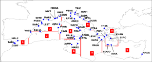
We assess the consistency of sea-level variability derived from tide-gauge (TG) and satellite radar altimeter (ALT) data acquired along the coasts of the Mediterranean Sea. For a coherent comparison between these techniques, we use GNSS observations to characterize the local vertical land movement embedded in TG records, but not affecting ALT data. We first investigate the performance of CMEMS, a gridded altimeter product covering the period 1993–2019. TG and GNSS series are not required to cover the whole altimeter period. The inter-technique comparison reveals good agreement at annual and semi-annual scales, but also the occasional occurrence of nonlinear discrepancies impacting trend estimation. Large-scale patterns of variability are observed in the Ionian region and along the continental shores from the Alboran to the Adriatic Sea. The estimates of linear trends based on TG + GNSS or CMEMS observations are found consistent within 1σ at 27/45 sites, with the best agreement in the Western Mediterranean and Adriatic Seas. We also consider the X-TRACK/ALES altimeter dataset, provided along the tracks of the Jason missions (2002–2018) and optimized for coastal applications. In this case, we identify only 12 sites suitable for the comparison. The results show that inter-technique consistency is impacted by the length of the series used in the comparison. Optimum agreement between X-TRACK/ALES and TG + GNSS trends is reached at the two sites closer to a satellite track. However, we find sites where X-TRACK/ALES-derived sea-level trends present suspicious along-track variations at < 5 km from the coast, where the corresponding 20 Hz series are incomplete and noisy.
中文翻译:
用潮汐仪和卫星雷达测高对地中海沿岸海平面测量的一致性
我们评估了从沿地中海沿岸获取的潮汐仪 (TG) 和卫星雷达高度计 (ALT) 数据得出的海平面变化的一致性。为了对这些技术进行一致的比较,我们使用 GNSS 观测来表征嵌入 TG 记录中的局部垂直陆地运动,但不影响 ALT 数据。我们首先研究 CMEMS 的性能,这是一种覆盖 1993-2019 年的网格高度计产品。TG 和 GNSS 系列不需要覆盖整个高度计周期。技术间比较揭示了在年度和半年度尺度上的良好一致性,但也偶尔会出现影响趋势估计的非线性差异。在爱奥尼亚地区和从阿尔伯兰到亚得里亚海的大陆海岸沿线观察到大尺度的变化模式。基于 TG + GNSS 或 CMEMS 观测的线性趋势估计在 27/45 地点的 1σ 范围内一致,在西地中海和亚得里亚海的一致性最好。我们还考虑了 X-TRACK/ALES 高度计数据集,该数据集沿 Jason 任务(2002-2018 年)的轨道提供,并针对沿海应用进行了优化。在这种情况下,我们只确定了 12 个适合比较的站点。结果表明,技术间的一致性受到比较中使用的系列长度的影响。X-TRACK/ALES 和 TG + GNSS 趋势之间的最佳一致性在靠近卫星轨道的两个站点达到。然而,我们发现 X-TRACK/ALES 衍生的海平面趋势在距离海岸 < 5 公里处呈现可疑的沿轨道变化的地点,其中相应的 20 Hz 序列不完整且嘈杂。


 京公网安备 11010802027423号