Gondwana Research ( IF 7.2 ) Pub Date : 2022-06-01 , DOI: 10.1016/j.gr.2022.05.011 Chloé M. Marcilly , Trond H. Torsvik , Clinton P. Conrad
|
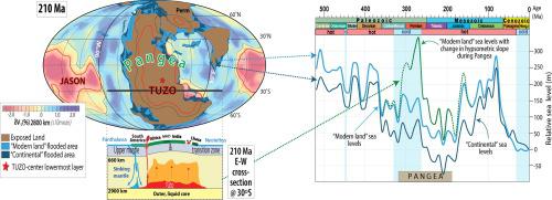
The validity of sea level estimates based on stratigraphic correlations has been debated since the 1990 s as relative sea level curves differ between sites due to local tectonics, different deposition rates and changes in dynamic topography. Here, we offer a new eustatic (global) sea level curve for the past 520 million years (Myrs) based on observations of global flooding. We use paleogeographic reconstructions to measure the area of today’s exposed land that was flooded in the past (modern-land flooding). We then apply the modern global hypsometric slope to reconstruct the sea level history. We find minimum sea levels (comparable to today’s level) towards the end of Pangea (210 Ma) and peak levels (∼280 m higher than today) at 80 Ma when Pangea was widely dispersed. A first-order “supercontinent” cycle of 250 million years (Myrs) is recognized but we also document a second-order cycle of 37 Myrs that was previously thought to be undetectable using the hypsometric method. The hypsometric slope is critical for reconstructing past sea levels, and steepening the hypsometric slope during Pangea assembly implies dramatically larger sea level fluctuations. Our new sea level curve shares strong similarities with stratigraphic constraints and correlates with seafloor production proxies throughout the Phanerozoic. Measurements of global flooding represent averages across great continental extents, making them less sensitive than stratigraphic analyses to regional-scale vertical land motion, such as from dynamic topography and hence more reliable for estimating eustatic sea level. This method can also help to identify local deviations caused by regional uplift or subsidence and serves to constrain geodynamic mechanisms for sea level change. Our new sea level reconstruction usefully tracks global variations in Phanerozoic eustatic sea level, but also opens opportunities to estimate such variations in deeper time.
中文翻译:
来自古地理洪水图的全球显生宙海平面
自 1990 年代以来,基于地层相关性的海平面估计的有效性一直存在争议,因为由于当地构造、不同的沉积速率和动态地形的变化,不同地点的相对海平面曲线不同。在这里,我们根据对全球洪水的观测,提供了过去 5.2 亿年 (Myrs) 的新海平面曲线。我们使用古地理重建来测量过去被洪水淹没的今天裸露土地的面积(现代土地洪水)。然后,我们应用现代全球高度斜率来重建海平面历史。当Pangea 广泛分布时,我们发现在Pangea(210 Ma)末端(210 Ma)和峰值水平(比今天高~280 m)的最低海平面(与今天的水平相当)在80 Ma 时Pangea 广泛分布。2.5 亿年 (Myrs) 的一级“超大陆”周期得到认可,但我们还记录了 37 Myrs 的二级周期,以前认为使用测压法无法检测到。高度斜率对于重建过去的海平面至关重要,并且在 Pangea 组装期间使高度斜率变陡意味着海平面波动显着增加。我们的新海平面曲线与地层限制具有很强的相似性,并且与整个显生宙的海底生产代理相关。全球洪水的测量值代表了整个大陆范围内的平均值,这使得它们对区域尺度的垂直陆地运动(例如动态地形)的地层分析不太敏感,因此对于估计海平面海平面更可靠。该方法还可以帮助识别由区域隆起或沉降引起的局部偏差,并用于约束海平面变化的地球动力学机制。我们新的海平面重建有效地跟踪了显生宙海平面的全球变化,但也为在更深的时间估计这种变化提供了机会。该方法还可以帮助识别由区域隆起或沉降引起的局部偏差,并用于约束海平面变化的地球动力学机制。我们新的海平面重建有效地跟踪了显生宙海平面的全球变化,但也为在更深的时间估计这种变化提供了机会。该方法还可以帮助识别由区域隆起或沉降引起的局部偏差,并用于约束海平面变化的地球动力学机制。我们新的海平面重建有效地跟踪了显生宙海平面的全球变化,但也为在更深的时间估计这种变化提供了机会。


 京公网安备 11010802027423号