Hydrogeology Journal ( IF 2.4 ) Pub Date : 2022-05-31 , DOI: 10.1007/s10040-022-02491-8 James K. Adamson , Wm. Javan Miner , Jonas L. Bernasconi
|
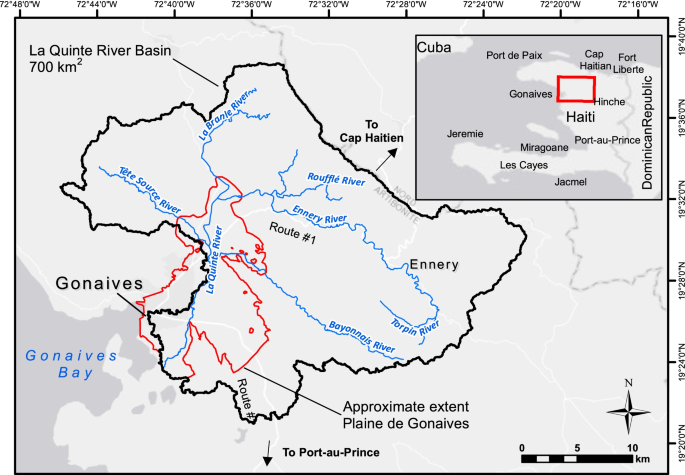
The Plaine des Gonaïves houses a regionally significant yet data-scarce coastal aquifer in one of the driest regions of Haiti. It is the primary source of water for the region, including Haiti’s third largest city, Gonaïves. Pressure on groundwater resources will be compounded as municipal water services modernize and energy infrastructure enables the resurgence of commercial agriculture. In anticipation of increased stress and greater impacts, this study was undertaken (including data discovery, reconnaissance, and analysis) to gain insights and to advance understanding of the groundwater resources. The alluvial aquifer covers >115 km2, exceeds 100 m thickness, and supports pumping yields as high as 532 m3/h. The heterogeneous multilayer aquifer exhibits hydraulic conductivities that range by an order of magnitude, influencing groundwater flow, residence times, and chemistry. Significant recharge occurs in the central and upgradient portions of the plain; river infiltration appears to be a more significant recharge source than direct infiltration. In the downgradient portion of the plain, confined aquifer pressure increases and discharge areas include the Quinte River, springs, wetlands, ditches and canals. Underlying the alluvium, discontinuous groundwater in bedrock with structural influence may mix with the alluvial aquifer, affecting isotopic composition and water chemistry. Increased abstraction, climate change, and intensification of agriculture and urban development could have consequential impacts on water quantity, water quality and ecosystems. The results, insights, and supporting datasets are a baseline to guide planning and to advance a hydrogeological conceptual model that supports sustainable and informed groundwater management.
中文翻译:
用于推进海地 Plaine des Gonaïves 地下水资源特征的数据和见解
Plaine des Gonaïves 在海地最干旱的地区之一拥有一个具有区域意义但数据稀缺的沿海含水层。它是该地区的主要水源,包括海地第三大城市戈纳伊夫。随着市政供水服务现代化和能源基础设施促进商业农业的复苏,地下水资源的压力将加剧。由于预期压力会增加和影响更大,因此进行了这项研究(包括数据发现、侦察和分析),以获取洞察力并促进对地下水资源的了解。冲积含水层覆盖 >115 km 2,厚度超过 100 m,并支持高达 532 m 3的抽水产量/H。非均质多层含水层的水力传导率在一个数量级范围内,影响地下水流量、停留时间和化学性质。平原的中部和上抬部分出现大量补给;河流入渗似乎是比直接入渗更重要的补给源。在平原的下坡部分,承压含水层压力增加,排放区域包括昆特河、泉水、湿地、沟渠和运河。在冲积层之下,受构造影响的基岩中不连续的地下水可能与冲积含水层混合,影响同位素组成和水化学。抽取的增加、气候变化以及农业和城市发展的集约化可能会对水量产生相应的影响,水质和生态系统。结果、见解和支持数据集是指导规划和推进支持可持续和知情地下水管理的水文地质概念模型的基准。


 京公网安备 11010802027423号