Precision Agriculture ( IF 5.4 ) Pub Date : 2022-05-29 , DOI: 10.1007/s11119-022-09907-1 Yi Bai , Chenwei Nie , Hongwu Wang , Minghan Cheng , Shuaibing Liu , Xun Yu , Mingchao Shao , Zixu Wang , Siyu Wang , Nuremanguli Tuohuti , Lei Shi , Bo Ming , Xiuliang Jin
|
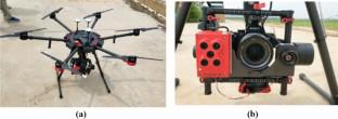
Acquiring the crop plant count is critical for enhancing field decision-making at the seedling stage. Remote sensing using unmanned aerial vehicles (UAVs) provide an accurate and efficient way to estimate plant count. However, there is a lack of a fast and robust method for counting plants in crops with equal spacing and overlapping. Moreover, previous studies only focused on the plant count of a single crop type. Therefore, this study developed a method to fast and non-destructively count plant numbers using high-resolution UAV images. A computer vision-based peak detection algorithm was applied to locate the crop rows and plant seedlings. To test the method’s robustness, it was used to estimate the plant count of two different crop types (maize and sunflower), in three different regions, at two different growth stages, and on images with various resolutions. Maize and sunflower were chosen to represent equidistant crops with distinct leaf shapes and morphological characteristics. For the maize dataset (with different regions and growth stages), the proposed method attained R2 of 0.76 and relative root mean square error (RRMSE) of 4.44%. For the sunflower dataset, the method resulted in R2 and RRMSE of 0.89 and 4.29%, respectively. These results showed that the proposed method outperformed the watershed method (maize: R2 of 0.48, sunflower: R2 of 0.82) and better estimated the plant numbers of high-overlap plants at the seedling stage. Meanwhile, the method achieved higher accuracy than watershed method during the seedling stage (2–4 leaves) of maize in both study sites, with R2 up to 0.78 and 0.91, respectively, and RRMSE of 2.69% and 4.17%, respectively. The RMSE of plant count increased significantly when the image resolution was lower than 1.16 cm and 3.84 cm for maize and sunflower, respectively. Overall, the proposed method can accurately count the plant numbers for in-field crops based on UAV remote sensing images.
中文翻译:
利用高分辨率无人机 RGB 图像快速、稳健地计算不同苗期向日葵和玉米植物数量的方法
获取作物植物数量对于加强幼苗阶段的田间决策至关重要。使用无人驾驶飞行器 (UAV) 进行遥感提供了一种准确有效的方法来估计植物数量。然而,缺乏一种快速而可靠的方法来计算等间距和重叠的作物中的植物。此外,以前的研究只关注单一作物类型的植物数量。因此,本研究开发了一种使用高分辨率无人机图像快速、无损地计算植物数量的方法。应用基于计算机视觉的峰值检测算法来定位作物行和植物幼苗。为了测试该方法的稳健性,它被用来估计两种不同作物类型(玉米和向日葵)在三个不同地区、两个不同生长阶段的植物数量,以及各种分辨率的图像。选择玉米和向日葵来代表具有不同叶形和形态特征的等距作物。对于玉米数据集(具有不同的区域和生长阶段),所提出的方法达到了 R2为 0.76,相对均方根误差 (RRMSE) 为 4.44%。对于向日葵数据集,该方法导致 R 2和 RRMSE 分别为 0.89 和 4.29%。这些结果表明,所提出的方法优于分水岭方法(玉米:R 2为 0.48,向日葵:R 2为 0.82),并且更好地估计了苗期高重叠植物的植物数量。同时,该方法在两个研究地点的玉米苗期(2-4叶)均取得了比分水岭法更高的准确度,R 2分别高达 0.78 和 0.91,RRMSE 分别为 2.69% 和 4.17%。当玉米和向日葵的图像分辨率分别低于 1.16 cm 和 3.84 cm 时,植物计数的 RMSE 显着增加。总体而言,所提出的方法可以基于无人机遥感图像准确计算大田作物的植物数量。


 京公网安备 11010802027423号