Carbonates and Evaporites ( IF 1.1 ) Pub Date : 2022-05-24 , DOI: 10.1007/s13146-022-00783-4 Ali Elmas
|
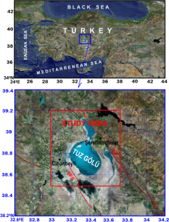
The Bouguer gravity data of this study were obtained from the World Gravity Map (WGM 2012) to investigate the sediment thickness beneath the basin of the Tuz Gölü. First of all, the average depths of the intra-sediment intermediate layers and sediment lower boundary topographies of the study area were calculated by taking the amplitude spectrum of gravity anomaly data of the study area. The total horizontal derivative method was used to reveal the discontinuities below the sediment and at the top of the basement. This method was applied to the gravity data caused by the basement units obtained by filtering the gravity anomaly data. Lineaments consisting of high-amplitude values are taken into account in the total horizontal derivative anomaly map to display the discontinuity boundaries at the desired depths. Within the scope of this study carried out in the research area, new discontinuity boundaries were determined. On the other hand, the basement upper surface topography of the study area, namely the sediment lower boundary topography, was mapped using the Parker–Oldenburg inversion algorithm. The accuracy of the depth values calculated by the inverse solution was tested by applying the Normalized Full Gradient (NFG) method to the two specified profiles. The results obtained with these two depth determination methods were approximately similar. Thus, the sediment thickness found using both methods was found to be in the range of 4–10.5 km. Therefore, the sediment thickness calculated from the inverse solution and NFG methods is compatible with each other within the error limits of ± 0.1 km under these two profiles.
中文翻译:
Tuz Gölü 盆地的沉积物厚度使用重力数据
本研究的布格重力数据来自世界重力图(WGM 2012),用于研究 Tuz Gölü 盆地下方的沉积物厚度。首先,利用研究区重力异常数据的幅值谱计算研究区沉积内中间层和沉积物下边界地形的平均深度。总水平导数法用于揭示沉积物下方和基底顶部的不连续性。该方法应用于对重力异常数据进行滤波得到的地下室单元所产生的重力数据。在总水平导数异常图中考虑了由高幅度值组成的线条,以显示所需深度的不连续边界。在本研究范围内进行的研究范围内,确定了新的不连续边界。另一方面,利用Parker-Oldenburg反演算法绘制了研究区基底上表面地形,即沉积物下边界地形。通过对两个指定剖面应用归一化全梯度(NFG)方法来测试逆解计算的深度值的准确性。这两种深度测定方法获得的结果大致相似。因此,发现使用这两种方法发现的沉积物厚度在 4-10.5 km 范围内。因此,逆解法和NFG法计算的沉积物厚度在这两种剖面下的±0.1 km误差范围内相互兼容。确定了新的不连续边界。另一方面,利用Parker-Oldenburg反演算法绘制了研究区基底上表面地形,即沉积物下边界地形。通过对两个指定剖面应用归一化全梯度(NFG)方法来测试逆解计算的深度值的准确性。这两种深度测定方法获得的结果大致相似。因此,发现使用这两种方法发现的沉积物厚度在 4-10.5 km 范围内。因此,逆解法和NFG法计算的沉积物厚度在这两种剖面下的±0.1 km误差范围内相互兼容。确定了新的不连续边界。另一方面,利用Parker-Oldenburg反演算法绘制了研究区基底上表面地形,即沉积物下边界地形。通过对两个指定剖面应用归一化全梯度(NFG)方法来测试逆解计算的深度值的准确性。这两种深度测定方法获得的结果大致相似。因此,发现使用这两种方法发现的沉积物厚度在 4-10.5 km 范围内。因此,逆解法和NFG法计算的沉积物厚度在这两种剖面下的±0.1 km误差范围内相互兼容。利用Parker-Oldenburg反演算法绘制了研究区基底上表面地形,即沉积物下边界地形。通过对两个指定剖面应用归一化全梯度(NFG)方法来测试逆解计算的深度值的准确性。这两种深度测定方法获得的结果大致相似。因此,发现使用这两种方法发现的沉积物厚度在 4-10.5 km 范围内。因此,逆解法和NFG法计算的沉积物厚度在这两种剖面下的±0.1 km误差范围内相互兼容。利用Parker-Oldenburg反演算法绘制了研究区基底上表面地形,即沉积物下边界地形。通过对两个指定剖面应用归一化全梯度(NFG)方法来测试逆解计算的深度值的准确性。这两种深度测定方法获得的结果大致相似。因此,发现使用这两种方法发现的沉积物厚度在 4-10.5 km 范围内。因此,逆解法和NFG法计算的沉积物厚度在这两种剖面下的±0.1 km误差范围内相互兼容。通过对两个指定剖面应用归一化全梯度(NFG)方法来测试逆解计算的深度值的准确性。这两种深度测定方法获得的结果大致相似。因此,发现使用这两种方法发现的沉积物厚度在 4-10.5 km 范围内。因此,逆解法和NFG法计算的沉积物厚度在这两种剖面下的±0.1 km误差范围内相互兼容。通过对两个指定剖面应用归一化全梯度(NFG)方法来测试逆解计算的深度值的准确性。这两种深度测定方法获得的结果大致相似。因此,发现使用这两种方法发现的沉积物厚度在 4-10.5 km 范围内。因此,逆解法和NFG法计算的沉积物厚度在这两种剖面下的±0.1 km误差范围内相互兼容。


 京公网安备 11010802027423号