Hydrogeology Journal ( IF 2.4 ) Pub Date : 2022-05-17 , DOI: 10.1007/s10040-022-02492-7 Louis Boansi Okofo , Marion Martienssen
|
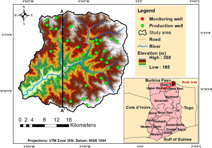
Increasing population growth and global climatic changes threaten water security in semiarid regions such as Northern Ghana. The Tamnean Plutonic Suite aquifer is the main source of water supply for the inhabitants of the Tamne River basin, which is a transboundary subbasin of the White Volta Basin, Ghana. The basin is a flood-prone area where flooding occurs every rainy season, but there is water scarcity during the dry season, mainly due to poor groundwater resources planning. It is expected that the population will increase in the next 10 years, implying a greater water demand. A steady-state and transient groundwater flow model has been developed to understand the hydrogeological conditions and assess the feasibility of managed aquifer recharge (MAR) in the area. A single granitic aquifer formation was delineated from the three-dimensional lithology modelling. The calibrated aquifer recharge through precipitation is very low due to high evapotranspiration and low rainfall. A MAR injection scenario was tested using the available treated floodwater that is registered during the rainy season in the area. The results show the total volume of water injected at the end of the 4-month study period is 11,000 m3/day (approximately 1.3 × 10⁶ m3), which significantly increases aquifer storage and groundwater levels. The volume of water recovered at the end of 8 months (1.4 × 10⁶ m3) is enough for domestic and irrigation purposes during the dry season. In general, MAR is feasible in augmenting the water levels in the area when combined with controllable irrigation and domestic withdrawals.
中文翻译:
用于评估加纳 Tamne 河流域管理含水层补给可行性的三维数值地下水流模型
不断增长的人口增长和全球气候变化威胁着加纳北部等半干旱地区的水安全。Tamnean Plutonic Suite 含水层是 Tamne 河流域居民的主要供水来源,该河流域是加纳白沃尔特盆地的跨界次流域。该流域是洪水多发地区,每年雨季都会发生洪水,但旱季缺水,主要是由于地下水资源规划不善。预计未来 10 年人口将增加,这意味着更大的用水需求。已经开发了一个稳态和瞬态地下水流模型,以了解水文地质条件并评估该地区管理含水层补给 (MAR) 的可行性。从三维岩性模型中描绘了一个单一的花岗岩含水层。由于高蒸发量和低降雨量,通过降水校准的含水层补给量非常低。使用在该地区雨季登记的可用处理过的洪水测试了 MAR 注入方案。结果显示,在为期 4 个月的研究期结束时,注入的总水量为 11,000 m3 /天(约 1.3 × 10 6 m 3),显着增加含水层蓄水量和地下水位。8 个月末回收的水量(1.4 × 10 6 m 3)足以在旱季用于家庭和灌溉用途。一般来说,结合可控灌溉和家庭取水,MAR 在增加该地区的水位方面是可行的。


 京公网安备 11010802027423号