Gondwana Research ( IF 7.2 ) Pub Date : 2022-05-10 , DOI: 10.1016/j.gr.2022.05.005 Syed Wajid Hanif Bukhari 1, 2, 3 , Sanzhong Li 1, 2 , Ze Liu 1, 2 , Yanhui Suo 1, 2 , Jie Zhou 1, 2 , Liming Dai 1, 2 , Pengcheng Wang 1, 2 , Ian Somerville 4
|
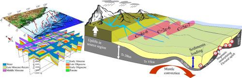
The sediments and their temporal and spatial distribution on Earth are the archives of interaction between deep and surface processes. Numerous simulations have attempted to decipher the evolution of landscape and sedimentary basins. However, it remains a challenge to couple paleogeographic evolution with deep geodynamics, especially at the continental margins such as the Northern South China Sea Margin (NSCSM). Here we employ a numerical simulating tool (Badlands) for the tectono-sedimentary evolution of the NSCSM to test and compare our restored interpolated paleo-bathymetries with previously published paleogeography. Based on the subsequent reconstruction of cumulative sediment thicknesses at the distal boundary of the continental margin, we found that the erodibility and elastic thickness of the lithosphere are the best-fitted and the most promising parameters to isostatically deal with deep dynamics in controlling regional topography. According to our findings, the Early Oligocene and Early Miocene are two stages of high erodibility and fast uplifting in the source provenances or weathering regions as well as lithospheric strengthening. In contrast, the lower values of elastic thickness indicate the Eocene rifting and Late Miocene reactivation of extension due to its lithospheric weakening, relative to the post-rift thickening.
Plain language summary: Transient deep and surface processes actively participated in the geography of Earth’s landscape and sediment distribution. It takes millions of years for these processes and remains challenging to investigate the past landscape evolution. However, in the era of numerical modelling and more advanced research, it is now possible to solve many scientific questions. This study also attempted to find paleogeographic core findings based on the combined effect of deep and surface processes using a numerical simulation tool, Badland. Finally, we establish an erosion as a surface leading factor and an elastic thickness of lithosphere and mantle convection as the deep dynamic factors, to effect the Earth’s surface landscape and link with the accumulation of sediments.
中文翻译:
塑造地球的深层和表面驱动力:来自南海北部边缘演化的见解
地球上的沉积物及其时空分布是深部和地表过程相互作用的档案。许多模拟试图破译景观和沉积盆地的演变。然而,将古地理演化与深层地球动力学相结合仍然是一个挑战,特别是在南海北部边缘(NSCSM)等大陆边缘。这里我们使用了一个数值模拟工具(Badlands) 用于 NSCSM 的构造沉积演化,以测试和比较我们恢复的插值古水深与先前发表的古地理。基于随后对大陆边缘远端边界累积沉积厚度的重建,我们发现岩石圈的可蚀性和弹性厚度是等静压处理控制区域地形的深部动力学的最佳参数和最有希望的参数。根据我们的研究结果,早渐新世和早中新世是源源或风化区高可蚀性和快速隆升以及岩石圈强化的两个阶段。相比之下,较低的弹性厚度值表明始新世裂谷和晚中新世由于岩石圈减弱而重新激活伸展,
简单的语言总结:瞬态深层和表面过程积极参与了地球景观和沉积物分布的地理。这些过程需要数百万年的时间,并且调查过去的景观演变仍然具有挑战性。然而,在数值建模和更高级研究的时代,现在可以解决许多科学问题。本研究还尝试使用数值模拟工具Badland ,根据深部和地表过程的综合影响来寻找古地理核心发现。最后,我们将侵蚀作为地表主导因素,将岩石圈的弹性厚度和地幔对流作为深部动力因素,以影响地球表面景观并与沉积物的堆积联系起来。


 京公网安备 11010802027423号