ISPRS Journal of Photogrammetry and Remote Sensing ( IF 10.6 ) Pub Date : 2022-05-06 , DOI: 10.1016/j.isprsjprs.2022.04.022 Davide Festa 1 , Manuela Bonano 2 , Nicola Casagli 1, 3 , Pierluigi Confuorto 1 , Claudio De Luca 2 , Matteo Del Soldato 1 , Riccardo Lanari 2 , Ping Lu 4 , Michele Manunta 2 , Mariarosaria Manzo 2 , Giovanni Onorato 2 , Federico Raspini 1 , Ivana Zinno 2 , Francesco Casu 2
|
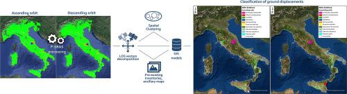
The rising availability of satellite-based multi-temporal interferometric datasets covering large areas of the Earth surface constitutes a huge asset in the context of operational workflows aimed at improving land risk assessment and management. In order to cost-effectively handle huge amount of data, we design a semi-automatic procedure to quickly identify, map and inventory ground and infrastructures displacements by means of spatial clustering performed over very large-scale Differential Synthetic Aperture Radar Interferometry (DInSAR) datasets. The detected deforming areas are then evaluated against the Line of Sight (LOS) velocity vector decomposition and the accessible ancillary layers for a preliminary classification of the triggering factors. We apply our methodology to the mean ascending and descending deformation maps covering the whole Italian territory resulting from 3294 and 2868 Sentinel-1 (S1) acquisitions respectively, spanning from March 2015 to December 2018 and processed through the Parallel Small BAseline Subset (P-SBAS) technique. By setting a displacement rate threshold of ± 1 cm/year, a total number of 14,638 areas resulting from both geometries are found to suffer from instability phenomena, the origin of which are in turn preliminary sorted in 11 classes split between natural causes and man-made activities. With 2 degrees of confidence, we classified landslide and subsidence events as the main causes of deformation within the Italian territory, constituting respectively 31% and 27% of the total unstable areas, followed by volcanic-related processes (22%). Lastly, we provide a complete overview of the deformation phenomena which have recently occurred on the Italian Peninsula starting from national scale statistical analysis and ending up with local scale investigations according to the deformation patterns visible through the vertical and East-West components of motion.
中文翻译:
通过 P-SBAS InSAR 测量的空间聚类在全国范围内绘制和分类地面变形现象:意大利案例研究
覆盖地球表面大片区域的基于卫星的多时相干涉数据集的可用性不断提高,这在旨在改善土地风险评估和管理的运营工作流程中构成了一项巨大的资产。为了经济高效地处理大量数据,我们设计了一个半自动程序,通过在超大规模差分合成孔径雷达干涉 (DInSAR) 数据集上执行的空间聚类,快速识别、映射和清点地面和基础设施位移. 然后根据视线 (LOS) 速度矢量分解和可访问的辅助层评估检测到的变形区域,以对触发因素进行初步分类。我们将我们的方法应用于覆盖整个意大利领土的平均上升和下降变形图,这些图分别由 2015 年 3 月至 2018 年 12 月的 3294 次和 2868 次 Sentinel-1 (S1) 收购产生,并通过平行小基线子集 (P-SBAS ) 技术。通过将位移率阈值设置为 ± 1 厘米/年,发现由两种几何形状产生的总共 14,638 个区域存在不稳定现象,其起源依次初步分为自然原因和人为原因的 11 类。做了活动。我们以 2 度的置信度将滑坡和沉降事件归类为意大利境内变形的主要原因,分别占总不稳定区域的 31% 和 27%,其次是火山相关过程 (22%)。最后,


 京公网安备 11010802027423号