Natural Resources Research ( IF 4.8 ) Pub Date : 2022-04-30 , DOI: 10.1007/s11053-022-10067-2 Imen Mezni 1 , Hayet Chihi 1 , Mohamed Aymen Bounasri 2 , Abdelhamid Ben Salem 2 , Simge Ayfer 3
|
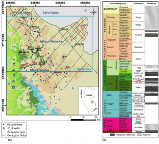
This work presents a comprehensive study based on geophysical and geological data to improve the characterization of regional multilayered reservoir systems in a complex geological setting. A combined approach, involving (a) data integration, (b) joint seismic-geological investigations, (c) mapping of reservoir surfaces and (d) 3D geological modeling, is proposed to characterize the “Jeffara of Medenine Basin” reservoir systems and to enhance the understanding of their functioning. The 3D geological modeling was performed using a 3D interpolation procedure based on potential field theory and integrating both observed data and knowledge-driven understanding. It was implemented using co-kriging techniques, involving two main variables: the “geological contact” and the “orientation data.” The interpolation was constrained by geological knowledge and hypotheses inferred through the stratigraphic pattern of the reservoir formations to be modeled and the faults affecting their continuity. A reliable 3D geological modeling was constructed, describing nine regional reservoir formations and associated structural features (folds and crosscutting faults). A comprehensive analysis of the outputs of the 3D geological model combined with a careful correlation of the potentiometric gradient/lithologic properties insured a better description of the reservoirs compartmentalization and connectivity and helped to construct the conceptual model of the fluid flow path at regional and local scales. All modeling results provide a direct foundation for subsequent numerical flow simulation and hydrodynamic modeling.
中文翻译:
用于 3D 地质建模的地球物理-地质组合调查:以突尼斯东南部梅德宁盆地 Jeffara 水库系统为例
这项工作提出了一项基于地球物理和地质数据的综合研究,以改善复杂地质环境中区域多层储层系统的表征。提出了一种组合方法,包括 (a) 数据集成、(b) 联合地震地质调查、(c) 储层表面绘图和 (d) 3D 地质建模,以描述“Medenine Basin 的 Jeffara”储层系统并加深对其功能的理解。3D 地质建模是使用基于势场理论的 3D 插值程序并结合观测数据和知识驱动的理解来执行的。它是使用联合克里金技术实施的,涉及两个主要变量:“地质接触”和“方向数据”。” 插值受到地质知识的限制,并且通过要建模的储层的地层模式和影响其连续性的断层推断出假设。构建了可靠的 3D 地质模型,描述了九个区域储层和相关的结构特征(褶皱和横切断层)。对 3D 地质模型输出的综合分析结合电位梯度/岩性特性的仔细关联,确保更好地描述储层划分和连通性,并有助于在区域和局部尺度上构建流体流动路径的概念模型. 所有建模结果为后续数值流动模拟和水动力建模提供了直接基础。


 京公网安备 11010802027423号