当前位置:
X-MOL 学术
›
Remote Sens. Ecol. Conserv.
›
论文详情
Our official English website, www.x-mol.net, welcomes your
feedback! (Note: you will need to create a separate account there.)
Riparian ecosystems mapping at fine scale: a density approach based on multi-temporal UAV photogrammetric point clouds
Remote Sensing in Ecology and Conservation ( IF 3.9 ) Pub Date : 2022-04-23 , DOI: 10.1002/rse2.267 Elena Belcore 1 , Melissa Latella 1
Remote Sensing in Ecology and Conservation ( IF 3.9 ) Pub Date : 2022-04-23 , DOI: 10.1002/rse2.267 Elena Belcore 1 , Melissa Latella 1
Affiliation
|
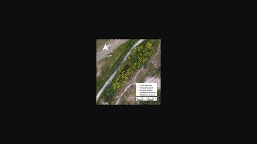
In recent years, numerous directives worldwide have addressed the conservation and restoration of riparian corridors, activities that rely on continuous vegetation mapping to understand its volumetric features and health status. Mapping riparian corridors requires not only fine-scale resolution but also the coverage of relatively large areas. The use of Unmanned Aerial Vehicles (UAV) allows for meeting both conditions, although the cost-effectiveness of their use is highly influenced by the type of sensor mounted on them. Few works have so far investigated the use of photogrammetric sensors for individual tree crown detection, despite being cheaper than the most common Light Detection and Ranging (LiDAR) ones. This work aims to improve the individual crown detection from UAV-photogrammetric datasets in a twofold way. Firstly, the effectiveness of a new approach that has already achieved interesting results in LiDAR applications was tested for photogrammetric point clouds. The test was carried out by comparing the accuracy achieved by the new approach, which is based on the point density features of the analysed dataset, with those related to the more common local maxima and textural methods. The results indicated the potentiality of the density-based method, which achieved accuracy values (0.76 F-score) consistent with the traditional methods (0.49–0.80 F-score range) but was less affected by under- and over-fitting. Secondly, the potential improvement of working on intra-annual multi-temporal datasets was assessed by applying the density-based approach to seven different scenarios, three of which were constituted by single-epoch datasets and the remaining given by the joining of the others. The F-score increased from 0.67 to 0.76 when passing from single- to multi-epoch datasets, aligning with the accuracy achieved by the new method when applied to LiDAR data. The results demonstrate the potential of multi-temporal acquisitions when performing individual crown detection from photogrammetric data.
中文翻译:

精细尺度的河岸生态系统制图:基于多时相无人机摄影测量点云的密度方法
近年来,世界各地的许多指令都涉及河岸走廊的保护和恢复,这些活动依赖于连续的植被测绘来了解其体积特征和健康状况。绘制河岸走廊不仅需要精细的分辨率,还需要覆盖相对较大的区域。无人驾驶飞行器 (UAV) 的使用可以满足这两个条件,尽管其使用的成本效益很大程度上受安装在其上的传感器类型的影响。迄今为止,很少有作品研究使用摄影测量传感器进行单个树冠检测,尽管它比最常见的光检测和测距 (LiDAR) 便宜。这项工作旨在以双重方式改进无人机摄影测量数据集中的个体冠检测。首先,已经在 LiDAR 应用中取得有趣结果的新方法的有效性已针对摄影测量点云进行了测试。该测试是通过比较新方法实现的准确度进行的,该方法基于分析数据集的点密度特征,与更常见的局部最大值和纹理方法相关。结果表明了基于密度的方法的潜力,该方法达到了准确度值(0.76F分数)与传统方法一致(0.49–0.80 F分数范围),但受欠拟合和过拟合的影响较小。其次,通过将基于密度的方法应用于七个不同的场景来评估处理年内多时态数据集的潜在改进,其中三个由单时期数据集构成,其余由其他数据集组成。当从单纪元数据集传递到多纪元数据集时, F- score 从 0.67 增加到 0.76,与新方法在应用于 LiDAR 数据时所达到的精度一致。结果证明了在从摄影测量数据执行单个牙冠检测时多时间采集的潜力。
更新日期:2022-04-23
中文翻译:
精细尺度的河岸生态系统制图:基于多时相无人机摄影测量点云的密度方法
近年来,世界各地的许多指令都涉及河岸走廊的保护和恢复,这些活动依赖于连续的植被测绘来了解其体积特征和健康状况。绘制河岸走廊不仅需要精细的分辨率,还需要覆盖相对较大的区域。无人驾驶飞行器 (UAV) 的使用可以满足这两个条件,尽管其使用的成本效益很大程度上受安装在其上的传感器类型的影响。迄今为止,很少有作品研究使用摄影测量传感器进行单个树冠检测,尽管它比最常见的光检测和测距 (LiDAR) 便宜。这项工作旨在以双重方式改进无人机摄影测量数据集中的个体冠检测。首先,已经在 LiDAR 应用中取得有趣结果的新方法的有效性已针对摄影测量点云进行了测试。该测试是通过比较新方法实现的准确度进行的,该方法基于分析数据集的点密度特征,与更常见的局部最大值和纹理方法相关。结果表明了基于密度的方法的潜力,该方法达到了准确度值(0.76F分数)与传统方法一致(0.49–0.80 F分数范围),但受欠拟合和过拟合的影响较小。其次,通过将基于密度的方法应用于七个不同的场景来评估处理年内多时态数据集的潜在改进,其中三个由单时期数据集构成,其余由其他数据集组成。当从单纪元数据集传递到多纪元数据集时, F- score 从 0.67 增加到 0.76,与新方法在应用于 LiDAR 数据时所达到的精度一致。结果证明了在从摄影测量数据执行单个牙冠检测时多时间采集的潜力。


 京公网安备 11010802027423号