当前位置:
X-MOL 学术
›
Basin Res.
›
论文详情
Our official English website, www.x-mol.net, welcomes your
feedback! (Note: you will need to create a separate account there.)
Reconstructing subsurface sandbody connectivity from temporal evolution of surface networks
Basin Research ( IF 2.8 ) Pub Date : 2022-04-03 , DOI: 10.1111/bre.12668 Elisabeth Steel 1, 2 , Chris Paola 2 , Austin Chadwick 2 , Jayaram Hariharan 3 , Paola Passalacqua 3 , Zhongyuan Xu 4 , Holly A. Michael 4 , Hannah Brommecker 1 , Elizabeth A. Hajek 5
Basin Research ( IF 2.8 ) Pub Date : 2022-04-03 , DOI: 10.1111/bre.12668 Elisabeth Steel 1, 2 , Chris Paola 2 , Austin Chadwick 2 , Jayaram Hariharan 3 , Paola Passalacqua 3 , Zhongyuan Xu 4 , Holly A. Michael 4 , Hannah Brommecker 1 , Elizabeth A. Hajek 5
Affiliation
|
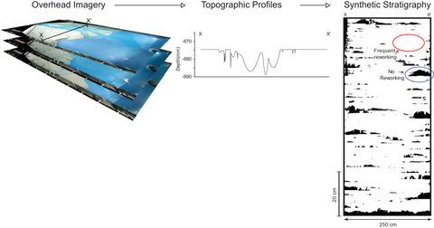
Characterization of groundwater aquifers and hydrocarbon reservoirs requires an understanding of the distribution and connectivity of subsurface sandbodies. In deltaic environments, distributary channel networks serve as the primary conduits for water and sediment. Once these networks are buried and translated into the subsurface, the coarse-grained channel fills serve as primary conduits for subsurface fluids such as water, oil or gas. The temporal evolution of channels on the surface therefore plays a first-order role in the 3D permeability and connectivity of subsurface networks. Land surface imagery is more broadly available than topographic or subsurface data, and time-series imagery of river networks can hold useful information for constraining the shallow subsurface. However, these reconstructions require an understanding of the degree to which channel bathymetry and river kinematics affect connectivity of subsurface sandbodies. Here, we present a novel method for building synthetic cross sections using overhead images of an experimental delta. We use principal components analysis to extract river networks from surface imagery, then couple this with an inverse-CDF method to estimate channel bathymetry, to generate a time-series of synthetic delta topography. This synthetic topography is then transformed, accounting for deposition and subsidence, to produce synthetic stratigraphy that differentiates coarse-grained channel fill from overbank and offshore deposition. We find that large-scale subsurface architecture is relatively insensitive to details of channel bathymetry, but instead is primarily controlled by channel location and kinematics. We analyse the connectivity of sand bodies and the geometries of barriers to flow and find that periods of rapid sea-level rise have more variability in sand body connectivity. We also find that barrier width decreases downstream during all sea-level phases. Our method generates synthetic stratigraphy that closely resembles the large-scale architecture and 2-dimensional connectivity of the real stratigraphy built during the experiment it was based on. We anticipate that it will be broadly applicable to other experimental and field-scale scenarios.
中文翻译:

从地表网络的时间演化重建地下砂体连通性
地下水含水层和油气藏的表征需要了解地下砂体的分布和连通性。在三角洲环境中,分流河道网络是水和沉积物的主要管道。一旦这些网络被掩埋并转移到地下,粗粒通道填充物就成为地下流体(如水、石油或天然气)的主要管道。因此,地表通道的时间演化在地下网络的 3D 渗透性和连通性中起着一级作用。地表图像比地形或地下数据更广泛可用,河网的时间序列图像可以包含用于限制浅层地下的有用信息。然而,这些重建需要了解河道测深和河流运动学对地下沙体连通性的影响程度。在这里,我们提出了一种使用实验三角洲的俯视图像构建合成横截面的新方法。我们使用主成分分析从地表图像中提取河网,然后将其与逆 CDF 方法相结合来估计河道水深,以生成时间序列的合成三角洲地形。然后,这种合成地形被转换,考虑到沉积和沉降,产生合成地层,将粗粒河道填充与上岸和海上沉积区分开来。我们发现大型地下结构对通道测深的细节相对不敏感,而是主要由通道位置和运动学控制。我们分析了沙体的连通性和流动障碍的几何形状,发现海平面快速上升的时期在沙体连通性方面具有更大的可变性。我们还发现,在所有海平面阶段,屏障宽度都在下游减小。我们的方法生成的合成地层非常类似于在其所基于的实验期间构建的真实地层的大规模架构和二维连通性。我们预计它将广泛适用于其他实验和现场规模的场景。我们还发现,在所有海平面阶段,屏障宽度都在下游减小。我们的方法生成的合成地层非常类似于在其所基于的实验期间构建的真实地层的大规模架构和二维连通性。我们预计它将广泛适用于其他实验和现场规模的场景。我们还发现,在所有海平面阶段,屏障宽度都在下游减小。我们的方法生成的合成地层非常类似于在其所基于的实验期间构建的真实地层的大规模架构和二维连通性。我们预计它将广泛适用于其他实验和现场规模的场景。
更新日期:2022-04-03
中文翻译:
从地表网络的时间演化重建地下砂体连通性
地下水含水层和油气藏的表征需要了解地下砂体的分布和连通性。在三角洲环境中,分流河道网络是水和沉积物的主要管道。一旦这些网络被掩埋并转移到地下,粗粒通道填充物就成为地下流体(如水、石油或天然气)的主要管道。因此,地表通道的时间演化在地下网络的 3D 渗透性和连通性中起着一级作用。地表图像比地形或地下数据更广泛可用,河网的时间序列图像可以包含用于限制浅层地下的有用信息。然而,这些重建需要了解河道测深和河流运动学对地下沙体连通性的影响程度。在这里,我们提出了一种使用实验三角洲的俯视图像构建合成横截面的新方法。我们使用主成分分析从地表图像中提取河网,然后将其与逆 CDF 方法相结合来估计河道水深,以生成时间序列的合成三角洲地形。然后,这种合成地形被转换,考虑到沉积和沉降,产生合成地层,将粗粒河道填充与上岸和海上沉积区分开来。我们发现大型地下结构对通道测深的细节相对不敏感,而是主要由通道位置和运动学控制。我们分析了沙体的连通性和流动障碍的几何形状,发现海平面快速上升的时期在沙体连通性方面具有更大的可变性。我们还发现,在所有海平面阶段,屏障宽度都在下游减小。我们的方法生成的合成地层非常类似于在其所基于的实验期间构建的真实地层的大规模架构和二维连通性。我们预计它将广泛适用于其他实验和现场规模的场景。我们还发现,在所有海平面阶段,屏障宽度都在下游减小。我们的方法生成的合成地层非常类似于在其所基于的实验期间构建的真实地层的大规模架构和二维连通性。我们预计它将广泛适用于其他实验和现场规模的场景。我们还发现,在所有海平面阶段,屏障宽度都在下游减小。我们的方法生成的合成地层非常类似于在其所基于的实验期间构建的真实地层的大规模架构和二维连通性。我们预计它将广泛适用于其他实验和现场规模的场景。


 京公网安备 11010802027423号