当前位置:
X-MOL 学术
›
Remote Sens. Ecol. Conserv.
›
论文详情
Our official English website, www.x-mol.net, welcomes your
feedback! (Note: you will need to create a separate account there.)
Land cover classification of treeline ecotones along a 1100 km latitudinal transect using spectral- and three-dimensional information from UAV-based aerial imagery
Remote Sensing in Ecology and Conservation ( IF 3.9 ) Pub Date : 2022-03-04 , DOI: 10.1002/rse2.260 Ida Marielle Mienna 1 , Kari Klanderud 1 , Hans Ole Ørka 1 , Anders Bryn 2, 3 , Ole Martin Bollandsås 1
Remote Sensing in Ecology and Conservation ( IF 3.9 ) Pub Date : 2022-03-04 , DOI: 10.1002/rse2.260 Ida Marielle Mienna 1 , Kari Klanderud 1 , Hans Ole Ørka 1 , Anders Bryn 2, 3 , Ole Martin Bollandsås 1
Affiliation
|
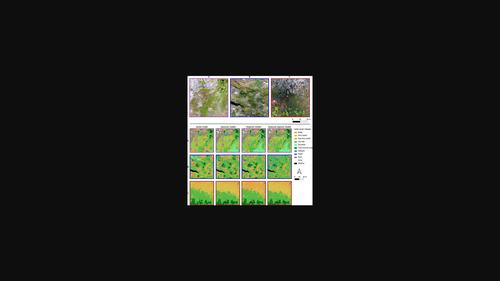
The alpine treeline ecotone is expected to move upwards in elevation with global warming. Thus, mapping treeline ecotones is crucial in monitoring potential changes. Previous remote sensing studies have focused on the usage of satellites and aircrafts for mapping the treeline ecotone. However, treeline ecotones can be highly heterogenous, and thus the use of imagery with higher spatial resolution should be investigated. We evaluate the potential of using unmanned aerial vehicles (UAVs) for the collection of ultra-high spatial resolution imagery for mapping treeline ecotone land covers. We acquired imagery and field reference data from 32 treeline ecotone sites along a 1100 km latitudinal gradient in Norway (60–69°N). Before classification, we performed a superpixel segmentation of the UAV-derived orthomosaics and assigned land cover classes to segments: rock, water, snow, shadow, wetland, tree-covered area and five classes within the ridge-snowbed gradient. We calculated features providing spectral, textural, three-dimensional vegetation structure, topographical and shape information for the classification. To evaluate the influence of acquisition time during the growing season and geographical variations, we performed four sets of classifications: global, seasonal-based, geographical regional-based and seasonal-regional-based. We found no differences in overall accuracy (OA) between the different classifications, and the global model with observations irrespective of data acquisition timing and geographical region had an OA of 73%. When accounting for similarities between closely related classes along the ridge-snowbed gradient, the accuracy increased to 92.6%. We found spectral features related to visible, red-edge and near-infrared bands to be the most important to predict treeline ecotone land cover classes. Our results show that the use of UAVs is efficient in mapping treeline ecotones, and that data can be acquired irrespective of timing within a growing season and geographical region to get accurate land cover maps. This can overcome constraints of a short field-season or low-resolution remote sensing data.
中文翻译:

使用基于无人机的航空影像的光谱和三维信息对沿 1100 公里纬度样带的树线交错带进行土地覆盖分类
随着全球变暖,高山林线交错带预计将向上移动。因此,绘制树线交错带对于监测潜在变化至关重要。以前的遥感研究主要集中在使用卫星和飞机来绘制树线交错带的地图。然而,林线交错带可能高度异质,因此应研究使用具有更高空间分辨率的图像。我们评估了使用无人机 (UAV) 收集超高空间分辨率图像以绘制林线交错带土地覆盖图的潜力。我们从挪威 1100 公里纬度梯度(60-69°N)的 32 个林线交错带站点获取了图像和现场参考数据。分类前,我们对无人机衍生的正射镶嵌图进行了超像素分割,并将土地覆盖类别分配给各个部分:岩石、水、雪、阴影、湿地、树木覆盖区域和山脊雪床梯度内的五个类别。我们计算了为分类提供光谱、纹理、三维植被结构、地形和形状信息的特征。为了评估生长季节和地理变化期间采集时间的影响,我们进行了四组分类:全球、基于季节、基于地理区域和基于季节性区域。我们发现不同分类之间的总体准确度 (OA) 没有差异,无论数据采集时间和地理区域如何,具有观测值的全球模型的 OA 为 73%。当考虑沿山脊雪床梯度密切相关的类之间的相似性时,准确率提高到 92.6%。我们发现与可见光、红边和近红外波段相关的光谱特征对于预测林线交错带土地覆盖类别最重要。我们的结果表明,使用无人机在绘制树线交错带方面是有效的,并且无论生长季节和地理区域内的时间如何,都可以获取数据,以获得准确的土地覆盖图。这可以克服短田季或低分辨率遥感数据的限制。我们的结果表明,使用无人机在绘制树线交错带方面是有效的,并且无论生长季节和地理区域内的时间如何,都可以获取数据,以获得准确的土地覆盖图。这可以克服短田季或低分辨率遥感数据的限制。我们的结果表明,使用无人机在绘制树线交错带方面是有效的,并且无论生长季节和地理区域内的时间如何,都可以获取数据,以获得准确的土地覆盖图。这可以克服短田季或低分辨率遥感数据的限制。
更新日期:2022-03-04
中文翻译:
使用基于无人机的航空影像的光谱和三维信息对沿 1100 公里纬度样带的树线交错带进行土地覆盖分类
随着全球变暖,高山林线交错带预计将向上移动。因此,绘制树线交错带对于监测潜在变化至关重要。以前的遥感研究主要集中在使用卫星和飞机来绘制树线交错带的地图。然而,林线交错带可能高度异质,因此应研究使用具有更高空间分辨率的图像。我们评估了使用无人机 (UAV) 收集超高空间分辨率图像以绘制林线交错带土地覆盖图的潜力。我们从挪威 1100 公里纬度梯度(60-69°N)的 32 个林线交错带站点获取了图像和现场参考数据。分类前,我们对无人机衍生的正射镶嵌图进行了超像素分割,并将土地覆盖类别分配给各个部分:岩石、水、雪、阴影、湿地、树木覆盖区域和山脊雪床梯度内的五个类别。我们计算了为分类提供光谱、纹理、三维植被结构、地形和形状信息的特征。为了评估生长季节和地理变化期间采集时间的影响,我们进行了四组分类:全球、基于季节、基于地理区域和基于季节性区域。我们发现不同分类之间的总体准确度 (OA) 没有差异,无论数据采集时间和地理区域如何,具有观测值的全球模型的 OA 为 73%。当考虑沿山脊雪床梯度密切相关的类之间的相似性时,准确率提高到 92.6%。我们发现与可见光、红边和近红外波段相关的光谱特征对于预测林线交错带土地覆盖类别最重要。我们的结果表明,使用无人机在绘制树线交错带方面是有效的,并且无论生长季节和地理区域内的时间如何,都可以获取数据,以获得准确的土地覆盖图。这可以克服短田季或低分辨率遥感数据的限制。我们的结果表明,使用无人机在绘制树线交错带方面是有效的,并且无论生长季节和地理区域内的时间如何,都可以获取数据,以获得准确的土地覆盖图。这可以克服短田季或低分辨率遥感数据的限制。我们的结果表明,使用无人机在绘制树线交错带方面是有效的,并且无论生长季节和地理区域内的时间如何,都可以获取数据,以获得准确的土地覆盖图。这可以克服短田季或低分辨率遥感数据的限制。


 京公网安备 11010802027423号