Landscape and Urban Planning ( IF 7.9 ) Pub Date : 2022-03-04 , DOI: 10.1016/j.landurbplan.2022.104395 Zofie Cimburova 1, 2 , Stefan Blumentrath 1
|
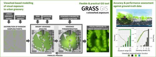
Quantifying green visual exposure is necessary to assess aesthetic, social and health benefits from urban greenery. Viewshed analysis has been successfully used to model and map green visual exposure from human perspective in continuous representation and in places where street view imagery for widely-used photography-based methods is not available. However, current viewshed-based methods for modelling green visual exposure are often difficult to generalise beyond their specific application purpose, inefficient in processing large spatial extents and have limited use due to demands on technical knowledge. This hampers their wider use in research and practice. In this paper, we develop a viewshed analysis-based method for modelling visual exposure to urban greenery with special focus on the method’s applicability in research and practice. The method is implemented as a tool in GRASS GIS which makes it available as a practical and flexible tool. Extensive validation and assessment of the method on the specific case of urban trees confirm that the method is a highly accurate alternative to modelling visual exposure from street view imagery (ρ = 0.96) but that data quality and viewshed parametrisation are essential for achieving accurate results. Thanks to parallel processing and effective implementation, the method is applicable for city-wide scale analysis with high-resolution data on commodity hardware (here illustrated on the case of Oslo, Norway). Therewith, the method has potential application in many areas including strategic tree planting, scenario modelling and urban ecosystem accounting, as well as ecosystem service research.
中文翻译:
基于视域的城市绿化视觉暴露建模——一种用于实际规划应用的高效 GIS 工具
量化绿色视觉暴露对于评估城市绿化带来的审美、社会和健康益处是必要的。视域分析已成功地用于从人类视角以连续表示形式和在无法获得广泛使用的基于摄影的街景图像的地方对绿色视觉曝光进行建模和映射。然而,当前基于视域的绿色视觉曝光建模方法通常难以概括超出其特定应用目的,在处理大空间范围时效率低下,并且由于对技术知识的需求而使用有限。这阻碍了它们在研究和实践中的广泛使用。在本文中,我们开发了一种基于视域分析的方法来模拟城市绿化的视觉暴露,特别关注该方法在研究和实践中的适用性。该方法在 GRASS GIS 中作为一种工具实现,使其成为一种实用且灵活的工具。针对城市树木的具体案例对该方法进行了广泛的验证和评估,证实该方法是一种高度准确的替代方法,可以替代街景图像的视觉曝光 (ρ = 0.96),但数据质量和视域参数化对于获得准确的结果至关重要。由于并行处理和有效实施,该方法适用于城市范围内的高分辨率商品硬件数据分析(此处以挪威奥斯陆为例)。因此,该方法在战略植树、情景建模和城市生态系统核算以及生态系统服务研究等领域具有潜在的应用价值。


 京公网安备 11010802027423号