当前位置:
X-MOL 学术
›
Remote Sens. Ecol. Conserv.
›
论文详情
Our official English website, www.x-mol.net, welcomes your feedback! (Note: you will need to create a separate account there.)
Mainstreaming remotely sensed ecosystem functioning in ecological niche models
Remote Sensing in Ecology and Conservation ( IF 5.5 ) Pub Date : 2022-02-15 , DOI: 10.1002/rse2.255 Adrián Regos 1, 2, 3, 4 , João Gonçalves 2, 4 , Salvador Arenas‐Castro 2, 4, 5, 6 , Domingo Alcaraz‐Segura 7, 8 , Antoine Guisan 9, 10 , João P. Honrado 2, 4, 11
Remote Sensing in Ecology and Conservation ( IF 5.5 ) Pub Date : 2022-02-15 , DOI: 10.1002/rse2.255 Adrián Regos 1, 2, 3, 4 , João Gonçalves 2, 4 , Salvador Arenas‐Castro 2, 4, 5, 6 , Domingo Alcaraz‐Segura 7, 8 , Antoine Guisan 9, 10 , João P. Honrado 2, 4, 11
Affiliation
|
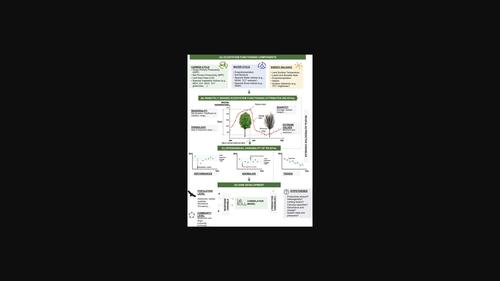
Biodiversity is declining globally at unprecedented rates. Ecological niche models (ENMs) are one of the most widely used toolsets to appraise global change impacts on biodiversity. Here, we identify a variety of advantages of incorporating remotely sensed ecosystem functioning attributes (EFAs) into ENMs. The development of ENMs that explicitly incorporate ecosystem functioning will allow a more holistic and integrative perspective of the habitat dynamics. The synergies between the increasingly available open-access satellite images and cloud-based platforms for planetary-scale geospatial analysis offer an unprecedented opportunity to incorporate ecosystem processes and disturbances (such as fires, insect outbreaks or droughts) that have been so far largely neglected in ecological niche characterization and modelling. The most paradigmatic example of EFAs is the application of time series of spectral vegetation indices related to primary productivity and carbon cycle. EFAs related to surface energy balance and water cycles derived from remote sensing products such as land surface temperature or soil moisture enable a fine-scale characterization of the species' niche—eventually improving the predictive performance of ENMs. All these advantages confirm that a new generation of ENMs based on such EFAs would offer great perspectives to increase our ability to monitor habitat suitability trends and population dynamics. However, despite the technical advances and increasing effort of remote sensing community to develop integrative EFAs, ENMs have yet to make full profit of the most recent developments by integrating them in ENMs. A coordinated agenda for remote sensing experts and ecological modellers will be essential over the coming years to bridge the gap between remote sensing and ecology disciplines and to take full (and timely) advantage of the fast-growing body of Earth observation data and remote sensing technologies—with special emphasis on the development and testing of new variables related to key processes driving ecosystem functioning.
中文翻译:

在生态位模型中主流化遥感生态系统功能
全球生物多样性正以前所未有的速度下降。生态位模型 (ENM) 是评估全球变化对生物多样性影响的最广泛使用的工具集之一。在这里,我们确定了将遥感生态系统功能属性 (EFA) 纳入 ENM 的各种优势。明确纳入生态系统功能的 ENM 的发展将使栖息地动态更加全面和综合。越来越多的开放获取卫星图像和用于行星尺度地理空间分析的基于云的平台之间的协同作用提供了一个前所未有的机会来整合迄今为止在很大程度上被忽视的生态系统过程和干扰(如火灾、昆虫爆发或干旱)。生态位表征和建模。EFA 最典型的例子是应用与初级生产力和碳循环相关的光谱植被指数时间序列。与地表温度或土壤湿度等遥感产品衍生的地表能量平衡和水循环相关的 EFA 能够对物种的生态位进行精细表征——最终提高 ENM 的预测性能。所有这些优势都证实,基于此类 EFA 的新一代 ENM 将为提高我们监测栖息地适宜性趋势和种群动态的能力提供很好的视角。然而,尽管遥感社区在开发综合 EFA 方面取得了技术进步和越来越多的努力,但 ENM 尚未通过将它们整合到 ENM 中来充分利用最新的发展。
更新日期:2022-02-15
中文翻译:
在生态位模型中主流化遥感生态系统功能
全球生物多样性正以前所未有的速度下降。生态位模型 (ENM) 是评估全球变化对生物多样性影响的最广泛使用的工具集之一。在这里,我们确定了将遥感生态系统功能属性 (EFA) 纳入 ENM 的各种优势。明确纳入生态系统功能的 ENM 的发展将使栖息地动态更加全面和综合。越来越多的开放获取卫星图像和用于行星尺度地理空间分析的基于云的平台之间的协同作用提供了一个前所未有的机会来整合迄今为止在很大程度上被忽视的生态系统过程和干扰(如火灾、昆虫爆发或干旱)。生态位表征和建模。EFA 最典型的例子是应用与初级生产力和碳循环相关的光谱植被指数时间序列。与地表温度或土壤湿度等遥感产品衍生的地表能量平衡和水循环相关的 EFA 能够对物种的生态位进行精细表征——最终提高 ENM 的预测性能。所有这些优势都证实,基于此类 EFA 的新一代 ENM 将为提高我们监测栖息地适宜性趋势和种群动态的能力提供很好的视角。然而,尽管遥感社区在开发综合 EFA 方面取得了技术进步和越来越多的努力,但 ENM 尚未通过将它们整合到 ENM 中来充分利用最新的发展。


 京公网安备 11010802027423号