当前位置:
X-MOL 学术
›
Basin Res.
›
论文详情
Our official English website, www.x-mol.net, welcomes your feedback! (Note: you will need to create a separate account there.)
Structural geometry and evolution of the Rukwa Rift Basin, Tanzania: Implications for helium potential
Basin Research ( IF 3.2 ) Pub Date : 2021-12-19 , DOI: 10.1111/bre.12646 Ernest Mulaya 1, 2 , Jon Gluyas 2 , Ken McCaffrey 2 , Thomas Phillips 2 , Chris Ballentine 3
Basin Research ( IF 3.2 ) Pub Date : 2021-12-19 , DOI: 10.1111/bre.12646 Ernest Mulaya 1, 2 , Jon Gluyas 2 , Ken McCaffrey 2 , Thomas Phillips 2 , Chris Ballentine 3
Affiliation
|
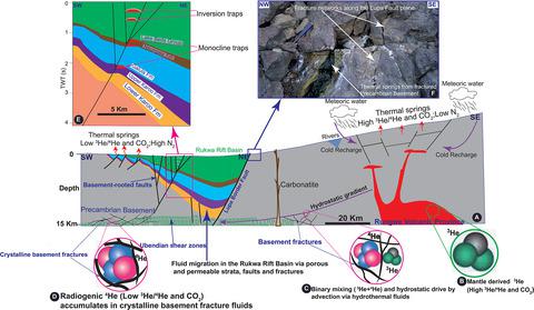
The Rukwa Rift Basin, Tanzania is regarded as a modern example of a cratonic rift zone despite complex polyphase extensional and episodic inversion structures. We interpret 2D seismic reflection data tied to wells to identify and describe structures controlling stratigraphic sequences (Late Carboniferous to Pleistocene) in two main segmented Rukwa Rift domains, A and B, which are controlled by the Chisi and Saza shear zones. Fault geometry and stratal patterns are illustrated in relation to their kinematic interaction with folds. Fold structures reflect both extensional and compressional deformation and were mapped with a particular interest for their helium potential. We illustrate fault bend folds, fault propagation folds and fault propagation monoclines that are related to extension events. Folds related to compression exhibit various structural styles reflecting at least two phases of episodic and widespread inversion. First, Early Jurassic inversion phase which involved multi-faulted anticlines in the Karoo strata. Second, a mild and widespread inversion structures during the Pleistocene which are characterised by both symmetrical and asymmetrical anticlines styles. Taken together, the extensional and compressional fold structures, stratal juxtapositions and unconformities define stratigraphic packages that are widely distributed in the Rukwa Rift Basin, and form potential subsurface traps for helium-nitrogen–rich gases, from which some seep to the surface, evidently documented in thermal springs across the region.
中文翻译:

坦桑尼亚鲁夸裂谷盆地的构造几何和演化:对氦潜力的影响
坦桑尼亚的鲁夸裂谷盆地被认为是克拉通裂谷带的现代例子,尽管具有复杂的多期伸展和幕式反转结构。我们解释与井相关的二维地震反射数据,以识别和描述控制两个主要分段 Rukwa 裂谷域 A 和 B 的地层序列(晚石炭世到更新世)的结构,这些域由 Chisi 和 Saza 剪切带控制。断层几何和地层模式与它们与褶皱的运动相互作用有关。褶皱结构反映了拉伸和压缩变形,并因其氦势而被绘制出来。我们说明了与伸展事件相关的断层弯曲褶皱、断层传播褶皱和断层传播单斜。与压缩有关的褶皱表现出不同的结构风格,反映了至少两个阶段的间歇性和广泛反转。一是早侏罗世反转阶段,涉及卡鲁地层多断层背斜。二是更新世温和而广泛的反转构造,其特征是对称和不对称的背斜样式。总而言之,伸展和压缩褶皱结构、地层并置和不整合定义了广泛分布在 Rukwa 裂谷盆地的地层包,并形成了潜在的富氦氮气体地下圈闭,其中一些气体从这些圈闭渗出到地表,显然有文献记载在整个地区的温泉。早侏罗世反转阶段涉及卡鲁地层多断层背斜。二是更新世温和而广泛的反转构造,其特征是对称和不对称的背斜样式。总而言之,伸展和压缩褶皱结构、地层并置和不整合定义了广泛分布在 Rukwa 裂谷盆地的地层包,并形成了潜在的富氦氮气体地下圈闭,其中一些气体从这些圈闭渗出到地表,显然有文献记载在整个地区的温泉。早侏罗世反转阶段涉及卡鲁地层多断层背斜。二是更新世温和而广泛的反转构造,其特征是对称和不对称的背斜样式。总而言之,伸展和压缩褶皱结构、地层并置和不整合定义了广泛分布在 Rukwa 裂谷盆地的地层包,并形成了潜在的富氦氮气体地下圈闭,其中一些气体从这些圈闭渗出到地表,显然有文献记载在整个地区的温泉。
更新日期:2021-12-19
中文翻译:
坦桑尼亚鲁夸裂谷盆地的构造几何和演化:对氦潜力的影响
坦桑尼亚的鲁夸裂谷盆地被认为是克拉通裂谷带的现代例子,尽管具有复杂的多期伸展和幕式反转结构。我们解释与井相关的二维地震反射数据,以识别和描述控制两个主要分段 Rukwa 裂谷域 A 和 B 的地层序列(晚石炭世到更新世)的结构,这些域由 Chisi 和 Saza 剪切带控制。断层几何和地层模式与它们与褶皱的运动相互作用有关。褶皱结构反映了拉伸和压缩变形,并因其氦势而被绘制出来。我们说明了与伸展事件相关的断层弯曲褶皱、断层传播褶皱和断层传播单斜。与压缩有关的褶皱表现出不同的结构风格,反映了至少两个阶段的间歇性和广泛反转。一是早侏罗世反转阶段,涉及卡鲁地层多断层背斜。二是更新世温和而广泛的反转构造,其特征是对称和不对称的背斜样式。总而言之,伸展和压缩褶皱结构、地层并置和不整合定义了广泛分布在 Rukwa 裂谷盆地的地层包,并形成了潜在的富氦氮气体地下圈闭,其中一些气体从这些圈闭渗出到地表,显然有文献记载在整个地区的温泉。早侏罗世反转阶段涉及卡鲁地层多断层背斜。二是更新世温和而广泛的反转构造,其特征是对称和不对称的背斜样式。总而言之,伸展和压缩褶皱结构、地层并置和不整合定义了广泛分布在 Rukwa 裂谷盆地的地层包,并形成了潜在的富氦氮气体地下圈闭,其中一些气体从这些圈闭渗出到地表,显然有文献记载在整个地区的温泉。早侏罗世反转阶段涉及卡鲁地层多断层背斜。二是更新世温和而广泛的反转构造,其特征是对称和不对称的背斜样式。总而言之,伸展和压缩褶皱结构、地层并置和不整合定义了广泛分布在 Rukwa 裂谷盆地的地层包,并形成了潜在的富氦氮气体地下圈闭,其中一些气体从这些圈闭渗出到地表,显然有文献记载在整个地区的温泉。


 京公网安备 11010802027423号