Landscape and Urban Planning ( IF 7.9 ) Pub Date : 2021-12-01 , DOI: 10.1016/j.landurbplan.2021.104318 Lisandro Agost 1 , Cecilia Estrabou 1 , Delia Aiassa 2
|
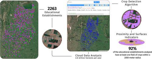
The American continent is the largest producer of genetically modified crops worldwide, characterized by the massive use of pesticides and agrochemicals, of which numerous scientific studies and reports show risks to human health. The child-youth population living in these regions constitutes an age group with its own characteristics that make it more vulnerable to possible exposure to pesticide use. The use of satellite information on cloud platforms can facilitate the measurement and creation of exploratory indicators over large study areas to assess the degree of exposure in educational establishments. The objective of this research is to create and evaluate exploratory indicators of the proximity of intensive crops to educational establishments in central Argentina, using satellite spatial–temporal analysis methodologies. The study was conducted in the province of Córdoba (Argentina). A total of 2263 public and private sector educational institutions were selected, both urban and rural. Perimeter rings were created in each establishment, at different distances up to 2000 m from the periphery. Satellite data of active summer crops in the period 2016–2019 were calculated using the Google Earth Engine. Proximity indicators and crop coverage areas were created. Ninety-two per cent of the educational establishments analyzed have at least one crop field nearby within a radius of 2000 m. More than half of these have fields that are 500 m or less away. The peripheral occupation of crops in more than half of the educational establishments varies between 25 and 100% (in the entire ring). The establishments in dispersed rural areas would be the most exposed, with an average proximity to the first field of less than 180 m. Kindergartens and primary schools are closer and have a higher percentage of peripheral crops than the secondary and special education schools. Our research reveals a worrying panorama that combines the proximity of educational establishments to fields cultivated with GM crops; research that shows a higher degree of exposure to agricultural pesticide pollution and adverse health effects for this age group, and local regulations that allow their application close to educational establishments and cities where they carry out their main activities.
中文翻译:
使用卫星指标监测大面积农工业作物与城市和农村教育机构的接近程度
美洲大陆是全球最大的转基因作物生产国,其特点是大量使用杀虫剂和农用化学品,其中大量科学研究和报告显示对人类健康构成风险。生活在这些地区的儿童青少年人口构成了一个具有其自身特征的年龄组,这使得他们更容易接触到可能使用的杀虫剂。在云平台上使用卫星信息可以促进在大型研究区域测量和创建探索性指标,以评估教育机构的暴露程度。本研究的目的是使用卫星时空分析方法创建和评估集约化作物与阿根廷中部教育机构的接近程度的探索性指标。该研究是在科尔多瓦省(阿根廷)进行的。共选择了 2263 所公立和私立教育机构,包括城市和农村。在每个机构中创建了周边环,距离周边的不同距离可达 2000 m。使用谷歌地球引擎计算了 2016-2019 年期间活跃夏季作物的卫星数据。创建了邻近指标和作物覆盖区域。所分析的教育机构中有 92% 在附近 2000 m 半径范围内至少有一个农田。其中一半以上的田地距离 500 m 或更短。一半以上的教育机构的周边作物占有率在 25% 到 100% 之间(在整个环中)。分散的农村地区的机构将是最暴露的,与第一场的平均接近度小于 180 m。与中等和特殊教育学校相比,幼儿园和小学距离更近,外围作物的比例更高。我们的研究揭示了一个令人担忧的全景,即教育机构与种植转基因作物的田地距离很近;研究表明,这一年龄段的人更容易接触农业农药污染和对健康产生不利影响,当地法规允许在靠近教育机构和他们开展主要活动的城市使用农药。我们的研究揭示了一个令人担忧的全景,即教育机构与种植转基因作物的田地距离很近;研究表明,这一年龄段的人更容易接触农业农药污染和对健康产生不利影响,当地法规允许在靠近教育机构和他们开展主要活动的城市使用农药。我们的研究揭示了一个令人担忧的全景,即教育机构与种植转基因作物的田地距离很近;研究表明,这一年龄段的人更容易接触农业农药污染和对健康产生不利影响,当地法规允许在靠近教育机构和他们开展主要活动的城市使用农药。


 京公网安备 11010802027423号