当前位置:
X-MOL 学术
›
Environ. Sci. Technol.
›
论文详情
Our official English website, www.x-mol.net, welcomes your
feedback! (Note: you will need to create a separate account there.)
Upscaling of Denitrification Rates from Point to Catchment Scales for Modeling of Nitrate Transport and Retention
Environmental Science & Technology ( IF 10.8 ) Pub Date : 2021-11-22 , DOI: 10.1021/acs.est.1c04593 Hyojin Kim 1 , Rasmus Jakobsen 2 , Jens Aamand 2 , Niels Claes 3 , Mogens Erlandsen 4 , Birgitte Hansen 1
Environmental Science & Technology ( IF 10.8 ) Pub Date : 2021-11-22 , DOI: 10.1021/acs.est.1c04593 Hyojin Kim 1 , Rasmus Jakobsen 2 , Jens Aamand 2 , Niels Claes 3 , Mogens Erlandsen 4 , Birgitte Hansen 1
Affiliation
|
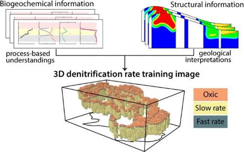
The spatial and temporal variability of denitrification makes it challenging to integrate conceptual, process-based understandings of nitrate transport and retention into numerical modeling at the catchment scale, although it is critical for the realism and predictive power of the model. In this study, we propose a novel approach where the conceptual understandings of the spatial structure of denitrification zones and the corresponding representative denitrification rates are transformed into a form that can be integrated into a multi-point statistical simulation framework. This is done by constructing a denitrification training image (TI) coupled to a geophysically based TI of the hydrogeological structure. The field observations and laboratory analyses of denitrification rates and the chemistry of water and sediment revealed that the study catchment’s subsurface can be characterized by three zones: (1) the oxic zone with no nitrate reduction; (2) the slow-denitrification zone (mean of ln-transformed rate = −1.19 ± 0.52 mg N L–1 yr–1); and (3) the high-denitrification zone (mean of ln-transformed rate = 3.86 ± 1.96 mg N L–1 yr–1). The underlying controls on the spatial distribution of these zones and the representativeness of denitrification rates were investigated. Then, a TI illustrating the subsurface structure of the denitrification zone was constructed by synthesizing the results of these geochemical interpretations and the hydrogeology TI.
中文翻译:

将反硝化速率从点扩展到集水区规模以模拟硝酸盐运输和滞留
反硝化的空间和时间可变性使得将硝酸盐传输和保留的概念性、基于过程的理解整合到流域尺度的数值模型中具有挑战性,尽管这对于模型的现实性和预测能力至关重要。在这项研究中,我们提出了一种新方法,将对反硝化带的空间结构和相应的代表性反硝化率的概念理解转化为一种可以集成到多点统计模拟框架中的形式。这是通过构建与基于地球物理的水文地质结构 TI 耦合的反硝化训练图像 (TI) 来完成的。对反硝化速率和水和沉积物化学的实地观察和实验室分析表明,研究集水区的地下可以分为三个区域:(1)没有硝酸盐还原的好氧带;(2) 慢反硝化带(ln转化率平均值=-1.19±0.52mg NL–1年–1 );(3) 高反硝化区(ln 转化率的平均值 = 3.86 ± 1.96 mg NL –1 yr –1)。研究了对这些区域空间分布的潜在控制和反硝化率的代表性。然后,通过综合这些地球化学解释和水文地质 TI 的结果,构建了说明反硝化区地下结构的 TI。
更新日期:2021-12-07
中文翻译:
将反硝化速率从点扩展到集水区规模以模拟硝酸盐运输和滞留
反硝化的空间和时间可变性使得将硝酸盐传输和保留的概念性、基于过程的理解整合到流域尺度的数值模型中具有挑战性,尽管这对于模型的现实性和预测能力至关重要。在这项研究中,我们提出了一种新方法,将对反硝化带的空间结构和相应的代表性反硝化率的概念理解转化为一种可以集成到多点统计模拟框架中的形式。这是通过构建与基于地球物理的水文地质结构 TI 耦合的反硝化训练图像 (TI) 来完成的。对反硝化速率和水和沉积物化学的实地观察和实验室分析表明,研究集水区的地下可以分为三个区域:(1)没有硝酸盐还原的好氧带;(2) 慢反硝化带(ln转化率平均值=-1.19±0.52mg NL–1年–1 );(3) 高反硝化区(ln 转化率的平均值 = 3.86 ± 1.96 mg NL –1 yr –1)。研究了对这些区域空间分布的潜在控制和反硝化率的代表性。然后,通过综合这些地球化学解释和水文地质 TI 的结果,构建了说明反硝化区地下结构的 TI。


 京公网安备 11010802027423号